9 Rue Pompallier
1 council report since June 2021, 1 carrying a photograph. The street’s heaviest record is 1 Rue Pompallier, 4 reports on file.
The green nearby
- L'aube Hill Reserve, you are in it · 7 ha
- Akaroa Recreation Ground, 93 m to the edge · Sports ground · 3 ha
- Akaroa Bowling Green, 133 m to the edge
- Settlers Hill Walkway, 168 m to the edge
- Akaroa Boat Park, 182 m to the edge · 2 ha
Parks within half a kilometre, measured to the boundary, the council’s open data. The whole roll is at /parks.
The civic shelf nearby
- Akaroa Collection Point, 44 m away · Transfer station
- Akaroa Service Centre, 249 m away · Service centre
Libraries, halls and the rest within half a kilometre, the council’s open data.
On the doorstep
- The Brasserie Kitchen & Wine Bar, 45 m away · Restaurants
- The Brasserie Kitchen, 51 m away · Restaurants
- The Bach, 64 m away · Cafés
- Lavaud 45 Boutique, 76 m away · Clothing
Businesses within four hundred metres, measured at the pin, OpenStreetMap and the council directories.
The named ground
Named water within 500 m of this address, measured to the line or the edge; Named places within 1.5 km of this address; the council’s own structure register, bridges, boardwalks and steps standing nearby, the open map’s record.
The remembered names nearby
- In Loving Memory of our Dear Friend Bernard Poujol Port De, 63 m away ·
In loving memory of our dear friend Bernard Poujol Port de Bouc 1930 - Paris 2000 Hilton &
· 2008 - French Cemetery, 79 m away ·
FRENCH CEMETERY
· 2008 - Old French Burial Ground, 80 m away ·
OLD FRENCH BURIAL GROUND
· 2008
Inscribed plaques within two hundred and fifty metres, the register’s pins, not surveyed spots. The whole roll is at /plaques.
What gets reported here
Photographed here 1 on record
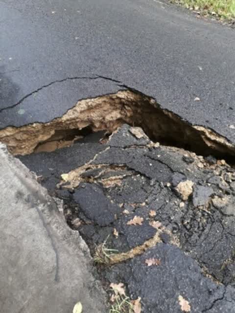
What’s on record
 Roading/Streets, 1 Jun 2021
Elsewhere on Rue Pompallier
- 1 Rue Pompallier, 4 reports
- 750 Rue Pompallier, 2 reports
- 800 Rue Pompallier, 1 report
- 700 Rue Pompallier, 1 report
The civic layer
This ground votes in Banks Peninsula ward, the Banks Peninsula community board is its local layer. Ward lines don’t always follow suburb lines; this one is measured at the pin, not the suburb’s centre. The whole roll is at /wards.
Rue Pompallier, the whole record → · Everything about Akaroa → · What stood on this ground → · On the map → · From the air, RetroLens holds the Crown’s aerials back to 1936; search the address there →
Questions, answered briefly
1 council report on record since June 2021, most often roading/streets (1).
Akaroa, Christchurch, on Rue Pompallier.
Nothing on the heritage register at this exact spot, the record around this ground →
L'aube Hill Reserve, the address is inside it, 7 ha.