29 Keighleys Road, Bromley
12 reports on record since November 2022 · 6 with photographs. The street’s heaviest record is 41 Keighleys Road — 58 reports on file. Indicative rating valuation and school zones, hazards, bin day and what stood here before.
What gets reported here
- Dumped Rubbish — 3
- Water Leak — 2
- Park - General Request — 2
- Facility - General Request — 2
- Vandalism - General — 1
- Street Cleaning — 1
Photographed here 6 on record




Reported here
 Water Leak —
  Street Cleaning —
 Very messy along cemetery side of Keighleys road on sidewalk and gutters, it also blows into Korora street. I think the gum trees need to c
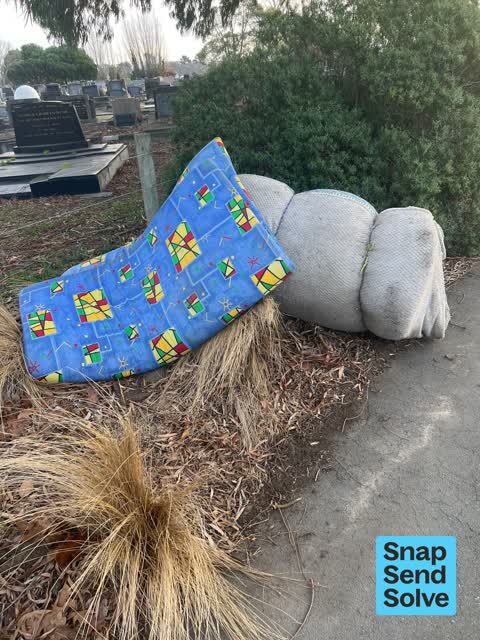
 Dumped Rubbish —
 Dumped mattresses. Near the entrance to the Bromley cemetery, but on the footpath.
 Vandalism - General —
 Someone has tried to remove bollard . Need to be concreted in .
 Facility - General Request —
 Bromley cemetery- The back access “gate” has been pulled out of the ground.
 Park - General Request —
 All the rubbish bins are overflowing
- Dumped Rubbish —
- Dumped Rubbish —
- Park - General Request —
- Graffiti —
- Water Leak —
- Facility - General Request —
Also reported on Keighleys Road
- 41 Keighleys Road — 58 reports
- 128 Keighleys Road — 39 reports
- 39 Keighleys Road — 17 reports
- 33 Keighleys Road — 13 reports
- 59 Keighleys Road — 11 reports
- 43 Keighleys Road — 9 reports
- 65 Keighleys Road — 5 reports
- 55 Keighleys Road — 5 reports
The street’s crash record
NZTA’s record names Keighleys Road in 18 crashes that hurt somebody since 2006 — 2 seriously hurt, nobody killed.
The green nearby
- Cypress Garden Reserve — 75 m to the edge · Sports ground · 4 ha
- Bromley Old School Reserve — 319 m to the edge · 2 ha
Parks within half a kilometre, measured to the boundary — the council’s open data.
The civic shelf nearby
- Bromley Cemetery — 8 m away · Cemetery
- Ruru Lawn Cemetery — 228 m away · Cemetery
Libraries, halls and the rest within half a kilometre — the council’s open data.
On the doorstep
- Lucky Cat Tattoo Studio — 357 m away · Tattoo & piercing
- Mc'Gregors Fish & Chips — 361 m away · Fast food
Businesses within four hundred metres, measured at the pin — OpenStreetMap and the council directories.
The bus nearby
The closest Metro stops, within four hundred and fifty metres.
The tracks through here
- Walk and bike track through Bromley — 464 m to the line · walk · bike
Tracks whose line passes within half a kilometre, measured to the line itself — the council’s open data.
The remembered names nearby
- With Loving Memories of Raymond Davies 1987 — 229 m away ·
WITH LOVING MEMORIES OF RAYMOND DAVIES 1987
· 2009 - Rest Awhile With Shona Davies — 230 m away ·
REST AWHILE WITH SHONA DAVIES
· 2009
Inscribed plaques within two hundred and fifty metres — the register’s pins, not surveyed spots. The whole roll is at /plaques.
Renting nearby
new bonds in Bromley ran about $560 a week — $10 above the city median of $550 — the suburb page keeps the rent record →.
The civic layer
This ground votes in Linwood ward — the Coastal-Burwood-Linwood community board. Ward lines don’t always follow suburb lines; this one is measured at the pin, not the suburb’s centre.
What stood on this ground → · On the map → · From the air — the Crown’s aerials back to 1936; search the address on RetroLens →
Questions, answered briefly
12 council reports on record since November 2022 — most often dumped rubbish (3), water leak (2), park - general request (2).
Bromley, Christchurch — on Keighleys Road.
Nothing on the heritage register at this exact spot — the record around this ground →
Cypress Garden Reserve — 75 m to its edge, 4 ha.