12 Rosella Street, Broomfield
12 reports on record since July 2023 · 10 with photographs. The most-reported address on Rosella Street. Indicative rating valuation and school zones, hazards, bin day and what stood here before.
What gets reported here
Photographed here 10 on record




Reported here
 Overgrown Vegetation —
 heaps of leaves have fallen and need to be swept up/gotten rid of before the weather turns. potential flood risk
 Rubbish and Bins - General —
 green bin damaged by green waste truck
 Trees - General —
 tree branches damaged by high winds
 Flooding —
 Flooding
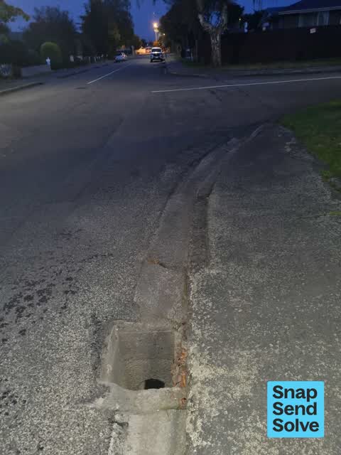
 Street Gutters / Storm Water —
 The cover for the drain has fallen in, leaving a deep hole uncovered and potentially unsafe.
 Trees - General —
 A large branch has been torn from a council tree from the wind we had this week, it has landed in our property and poses a risk to us and ou
 Flooding —
 Hi team, some terrible flooding on Rosella street, cars can no longer proceed through and I cannot leave my property via car.
 Dumped Rubbish —
 Someone has abandoned a couch on the burm
 Fallen Tree —
 This massive branch has fallen off the tree outside our property. I’m very dangerous. We feel like the tree needs some proper pruning too. I
 Flooding —
 Flooding - drains blocked
- Flooding —
- Trees - General —
Also reported on Rosella Street
- 21 Rosella Street — 11 reports
- 28 Rosella Street — 9 reports
- 11 Rosella Street — 8 reports
- 19 Rosella Street — 5 reports
- 7A Rosella Street — 2 reports
- 22 Rosella Street — 2 reports
- 13 Rosella Street — 2 reports
- 1 Rosella Street — 2 reports
The street’s crash record
NZTA’s record names Rosella Street in 1 crash that hurt somebody since 2006 — 0 seriously hurt, nobody killed.
The green nearby
- Rosella Reserve — 96 m to the edge · 1 ha
- Neathwest Reserve — 342 m to the edge · 2 ha
- Kilbrannan Reserve — 371 m to the edge
- Amdale Reserve — 455 m to the edge
- Arcon Playground — 497 m to the edge
Parks within half a kilometre, measured to the boundary — the council’s open data.
On the doorstep
- Airport Birches Motel — 213 m away · Motels
- Travellers Retreat Bed and Breakfast — 225 m away · Guest houses
- Kevin Hickman Retirement Village — 262 m away · Business
- Z — 277 m away · Petrol stations
Businesses within four hundred metres, measured at the pin — OpenStreetMap and the council directories.
The bus nearby
- Masham Rd near Kintyre Dr — 213 m away · route 125, route 140
- Masham Rd near Rosella St — 226 m away · route 125, route 140
The closest Metro stops, within four hundred and fifty metres.
The tracks through here
- Walk and bike track through Broomfield — 198 m to the line · walk · bike
- Walk and bike track through Broomfield — 199 m to the line · walk · bike
- Walk and bike track through Broomfield — 222 m to the line · walk · bike
Tracks whose line passes within half a kilometre, measured to the line itself — the council’s open data.
The named ground
the council’s own structure register — bridges, boardwalks and steps standing nearby — the open map’s record.
Renting nearby
new bonds in Broomfield ran about $600 a week — $50 above the city median of $550 — the suburb page keeps the rent record →.
The civic layer
This ground votes in Hornby ward — the Halswell-Hornby-Riccarton community board. Ward lines don’t always follow suburb lines; this one is measured at the pin, not the suburb’s centre.
What stood on this ground → · On the map → · From the air — the Crown’s aerials back to 1936; search the address on RetroLens →
Questions, answered briefly
12 council reports on record since July 2023 — most often flooding (4), trees - general (3), street gutters / storm water (1).
Broomfield, Christchurch — on Rosella Street.
Nothing on the heritage register at this exact spot — the record around this ground →
Rosella Reserve — 96 m to its edge, 1 ha.