57 Malabar Crescent, Broomfield
16 reports on record since October 2017 · 7 with photographs. The street’s heaviest record is 49 Malabar Crescent — 17 reports on file. Indicative rating valuation and school zones, hazards, bin day and what stood here before.
What gets reported here
- Dumped Rubbish — 9
- Parks — 2
- Pavement - General — 1
- Park - General Request — 1
- Graffiti somewhere else — 1
- Facility - General Request — 1
Photographed here 7 on record


Reported here
 Park - General Request —
 shrubs removed from park garden has exposed damaged boundary fence
 Dumped Rubbish —
 2 baby seats and boxes
 Graffiti somewhere else —
  Abandoned Vehicle —
 Appears to have been in position for some considerable time. WOF and Rego well expired
 Pavement - General —
 The edges a clear but the centre can e slippery when wet. See Arcon path near park and here see GPS locations.
- Facility - General Request —
- Dumped Rubbish —
- Dumped Rubbish —
- Dumped Rubbish —
- Dumped Rubbish —
- Dumped Rubbish —
- Dumped Rubbish —
- Dumped Rubbish —
- Dumped Rubbish —
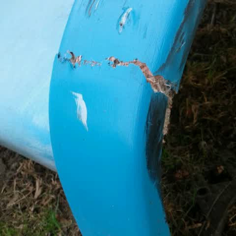
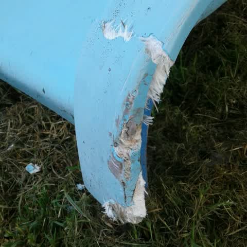
Parks —
Malabar reserve Slide damage
Parks —
Malabar reserve Slide damage
Also reported on Malabar Crescent
- 49 Malabar Crescent — 17 reports
- 47 Malabar Crescent — 11 reports
- 8 Malabar Crescent — 2 reports
- 55 Malabar Crescent — 2 reports
- 45 Malabar Crescent — 2 reports
- 4 Malabar Crescent — 2 reports
- 34 Malabar Crescent — 2 reports
- 18 Malabar Crescent — 2 reports
The street’s crash record
NZTA’s record names Malabar Crescent in 2 crashes that hurt somebody since 2006 — 0 seriously hurt, nobody killed.
The green nearby
- Malabar Reserve — you are in it
- Broomfield Common — 124 m to the edge · Sports ground · 9 ha
- Pensacola Reserve — 301 m to the edge
- Carradale Drainage Reserve — 310 m to the edge
- Laramie Reserve — 320 m to the edge
Parks within half a kilometre, measured to the boundary — the council’s open data.
The bus nearby
- Hei Hei Rd near Buchanans Rd — 127 m away · route 130
- Hei Hei Rd near Buchanans Rd — 143 m away · route 130
The closest Metro stops, within four hundred and fifty metres.
The tracks through here
- Walk and bike track through Broomfield — 408 m to the line · walk · bike
- Walk and bike track through Broomfield — 444 m to the line · walk · bike
- Walk and bike track through Broomfield — 489 m to the line · walk · bike
Tracks whose line passes within half a kilometre, measured to the line itself — the council’s open data.
Renting nearby
new bonds in Broomfield ran about $600 a week — $50 above the city median of $550 — the suburb page keeps the rent record →.
The civic layer
This ground votes in Hornby ward — the Halswell-Hornby-Riccarton community board. Ward lines don’t always follow suburb lines; this one is measured at the pin, not the suburb’s centre.
What stood on this ground → · On the map → · From the air — the Crown’s aerials back to 1936; search the address on RetroLens →
Questions, answered briefly
16 council reports on record since October 2017 — most often dumped rubbish (9), parks (2), pavement - general (1).
Broomfield, Christchurch — on Malabar Crescent.
Nothing on the heritage register at this exact spot — the record around this ground →
Malabar Reserve — the address is inside it.