2 Crosdale Place
10 council reports since December 2019, 6 carrying a photograph. The most-reported address on Crosdale Place.
From the air, then
Sourced from Canterbury Maps and partners. LINZ, CC BY 3.0 NZ. Each frame is cut from Environment Canterbury’s historic imagery MapServer for that decade, only where the Footprints layer names a CC BY survey (NZAM-covered spots stay out). RetroLens holds more Crown aerials →
The green nearby
- Burnside Park, 37 m to the edge · Sports ground · 29 ha · playground, 57 pieces
- Coringa Reserve, 124 m to the edge · playground, 22 pieces
- Avice Hill Reserve, 139 m to the edge · Botanic
- Lavendula Reserve, 141 m to the edge
- Stableford Reserve, 451 m to the edge
Parks within half a kilometre, measured to the boundary, the council’s open data. The whole roll is at /parks.
On the doorstep
- Avice Hill Arts and Craft Centre, 208 m away · Venues & events
- Airport Gateway Motor Lodge, 218 m away · Motels
- The Flight Lounge Cafe & Restaurant, 225 m away · Restaurants
- Airport Gateway Motel, 232 m away · Motels
Businesses within four hundred metres, measured at the pin, OpenStreetMap and the council directories.
The bus nearby
- Memorial Ave near Roydvale Ave, 188 m away · route 29
- Memorial Ave near Roydvale Ave, 189 m away · route 29
The closest Metro stops, within four hundred and fifty metres.
The tracks through here
- Walk and bike track through Burnside, 273 m to the line · walk · bike
- Walk and bike track through Burnside, 281 m to the line · walk · bike
- Walk and bike track through Burnside, 480 m to the line · walk · bike
Tracks whose line passes within half a kilometre, the council’s open data.
The named ground
the council’s own structure register, bridges, boardwalks and steps standing nearby, the open map’s record.
The remembered names nearby
- Planted on 2nd December 1994 by Mrs Avice Hill, 153 m away ·
PLANTED ON 2ND DECEMBER 1994 BY MRS AVICE HILL TO COMMEMORATE THE CENTENARY OF THE ORIGINA
· 2008 - Canterbury Herb Society, 174 m away ·
CANTERBURY HERB SOCIETY
· 2008
Inscribed plaques within two hundred and fifty metres, the register’s pins, not surveyed spots. The whole roll is at /plaques.
Renting nearby
new bonds in Burnside ran about $641 a week, $91 above the city median of $550, the suburb page keeps the rent record →.
What gets reported here
Photographed here 6 on record


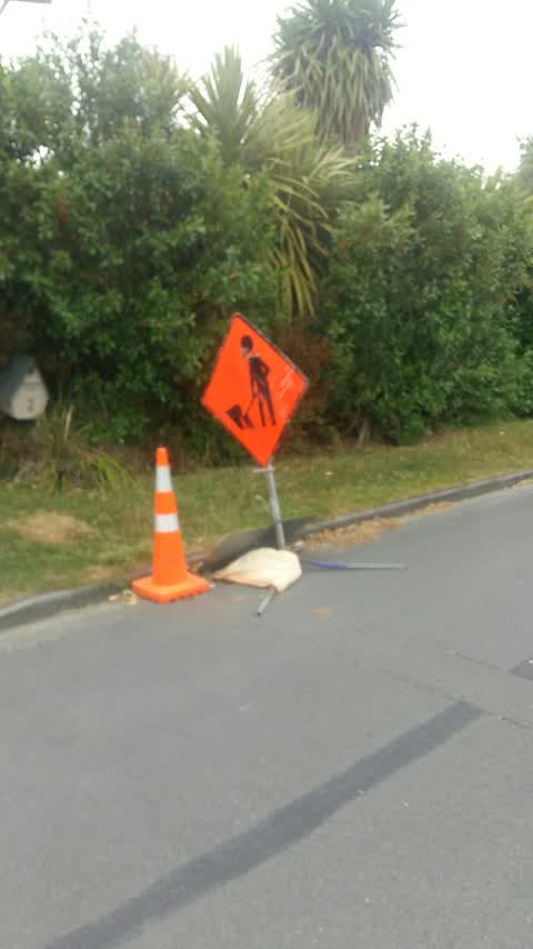
What’s on record
- Dumped Rubbish, 8 Apr 2026
dumped steel bookcase/display
 Overgrown Vegetation, 20 Feb 2025
 As you can see unable to open passengers door on car. Footpath completely blocked and over grown. Pedestrians walking on the road to Roydva
 Overgrown Vegetation, 15 Feb 2025
 Shrubbery on verge overgrown forcing cars into path of oncoming traffic.
 Abandoned Vehicle, 30 Jan 2025
 This car is parked with no number plates and the windows are down. It is also unlocked. Parked on Crosdale St Burnside.
 Overgrown Vegetation, 10 Jan 2025
 Large Catoniaster growing from private property over council garden. This is extending 1.5m over the road. Please arrange prunning
 Graffiti on a cabinet, pole or railway asset, 2 Jan 2025
- Damaged Street Sign, 5 Oct 2023
- Damaged Street Sign, 5 Oct 2023
- Hazard, vehicle, 18 Dec 2022
Roading/Streets, 30 Dec 2019
the relevant road works finished some weeks ago.
Elsewhere on Crosdale Place
- 26 Crosdale Place, 4 reports
- 3 Crosdale Place, 3 reports
- 27 Crosdale Place, 3 reports
- 20 Crosdale Place, 3 reports
- 16 Crosdale Place, 2 reports
- 7 Crosdale Place, 1 report
- 5 Crosdale Place, 1 report
- 24D Crosdale Place, 1 report
The street’s crash record
NZTA’s record names Crosdale Place in 1 crash that hurt somebody since 2006, 1 seriously hurt, nobody killed.
The civic layer
This ground votes in Waimairi ward, the Fendalton-Waimairi-Harewood community board is its local layer. Ward lines don’t always follow suburb lines; this one is measured at the pin, not the suburb’s centre. The whole roll is at /wards.
Crosdale Place, the whole record → · Everything about Burnside → · What stood on this ground → · On the map → · From the air, RetroLens holds the Crown’s aerials back to 1936; search the address there →
Questions, answered briefly
10 council reports on record since December 2019, most often overgrown vegetation (3), damaged street sign (2), roading/streets (1).
Burnside, Christchurch, on Crosdale Place.
Nothing on the heritage register at this exact spot, the record around this ground →
Burnside Park, 37 m to its edge, 29 ha.