Christchurch 360 Trail
Christchurch 360 Trail is an attraction in Christchurch Central City.
This 135 kilometre trail encircles the ever-changing panorama of Christchurch. It showcases and interprets the rich array of… Read full description ↓
One of 45 attractions in Christchurch Central City, 29% of the city’s count
Checked 27 Oct 2026
Reviews
Getting there
The map loads only when you ask for it.
Straight-line distances from the pin, not walking routes.
Nearby
More nearby places 5
Environment Canterbury’s Canterbury Maps Parks layer, refreshed 2026-10-10. Distances are straight-line from the business pin, not walking routes.
The nearest other attractions
More nearby attractions 5
All 45 attractions in Christchurch Central City → · Every one in the city →
Also in Christchurch Central City
More businesses in Christchurch Central City 7
What the record holds 6 sourced facts
What the record holds
| Fact | What the source says | Source |
|---|---|---|
| Kind | Attractions | Find Christchurch, 2024 |
| Website | christchurch360trail.org.nz | Find Christchurch, 2024 · its own site agrees |
| info@christchurch360trail.org.nz | Find Christchurch, 2024 | |
| NZBN | 9429046315786, Incorporated Society | NZBN register |
| Registered name | CHRISTCHURCH 360 TRAIL INCORPORATED | NZBN register |
| Registered since | 22 Aug 2017 | NZBN register |
Is this your business? Send hours, menu or photos, free and this page updates. Know its hours? Add them on OpenStreetMap, the page picks them up overnight.
How the council’s directory described it
Read the full description council directory, about 2024
This 135 kilometre trail encircles the ever-changing panorama of Christchurch. It showcases and interprets the rich array of natural, landscape, seascape and cultural features of the city, bringing to life gems previously hidden from view. Divided into 8 sections, the trail provides a unique, single or multi-day experience - easily accessed from anywhere in the city, the trail is mostly gentle, safe and increasingly serviced for food, transport and accommodation. Approximate distances: Godley Cliffs 16.1km, Estuary Marshes 19.4km, Dune Wetlands 15.7km, Brooklands Mouth 10.3km, Waimakariri Braids 18.8km, Avonhead Gardens 7.5km, Opawaho Divide 16.1km, Sugarloaf Hills 18.1km.
— Find Christchurch, 2024. The business’s own words from about 2024, repeated as a lead, not checked.
The ground it stands on
| Fact | What the source says | Source |
|---|---|---|
| District Plan zone | City centre zone | District Plan |
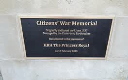 Citizens’ War Memorial / Originally Dedicated on 9 June 1937
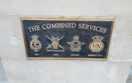 The Combined Services / [service Crests] / Navy
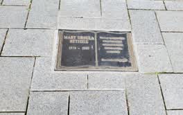 Godley Statue Reserve plaque
The reports nearby
7,198 council reports pinned within 250 m of the premises, most often Graffiti & vandalism and Roads & footpaths, 5,961 with a photograph. A pin is where a reporter stood, not a claim about the place itself.
The 7,198 reports on file
 Graffiti on a fence, building or structure
 Graffiti on a fence, building or structure
 Graffiti on a fence, building or structure
 Graffiti on a fence, building or structure
 Graffiti on a fence, building or structure
 Facility - General Request
 Litter
 Graffiti on a fence, building or structure
 Graffiti on a fence, building or structure
 Graffiti on a fence, building or structure
 Graffiti on a fence, building or structure
 Graffiti on a fence, building or structure
Questions, answered briefly
Read answers 7
An attraction in Christchurch Central City, Christchurch.
Somewhere in Christchurch Central City, the record holds no street address. On the map →
The council’s 2024 directory lists it, and a live NZBN entry says it still trades.
its website (Find Christchurch, 2024), email info@christchurch360trail.org.nz (Find Christchurch, 2024).
Alpine Safari (14 m), Hey Brew Craft Beer Tasting Tours (22 m), Kim's World (48 m), every one in the city.
6 other premises within a short walk, nearest Alpine Safari (14 m); the Hereford St near Colombo St bus stop is 121 m away: route 8; a cycle lane passes the door; nearest park: The Stewart Plaza (87 m).
The record behind this
This page is the union of what these public sources say, each fact above names the one it came from. A listing is a lead, not a promise the business still trades:
Sources: Find Christchurch · Christchurch District Plan layers · Christchurch City Council off-street parking layer (CC BY 4.0) · Environment Canterbury’s Metro stop record · Christchurch City Council’s cycleway layer · The business’s own website · New Zealand Business Number register
Read source notes 7
- Find Christchurch, the council’s business directory, a snapshot last touched about March 2024 (CC BY 4.0)
- Christchurch District Plan layers, zones, commercial centres and scheduled heritage items, from the council’s open data (CC BY 4.0)
- Christchurch City Council off-street parking layer (CC BY 4.0),
- Environment Canterbury’s Metro stop record, distances measured here from the pin
- Christchurch City Council’s cycleway layer, lanes, separated paths and the named Major Cycle Routes (CC BY 4.0)
- The business’s own website, read politely by chch.live for contact details the open record is missing, re-checked monthly
- New Zealand Business Number register, the public facts every NZBN entity files (legal name, status, registration date, industry), matched here by name and address
Map data © OpenStreetMap contributors (ODbL); council and ECan data under CC BY 4.0; Wikidata CC0. Something wrong? Fix it on OpenStreetMap or tell us. The whole directory lives at /businesses. This page as markdown: /business/christchurch-360-trail-christchurch-central-city.md.