63 Sturrocks Road, Casebrook
24 reports on record since August 2020 · 18 with photographs. The most-reported address on Sturrocks Road. Indicative rating valuation and school zones, hazards, bin day and what stood here before.
What gets reported here
Photographed here 18 on record




Reported here
 Graffiti on a sign, mural or public art —
 Tag on sign at Sturrocks Road entrance to Barnes Reserve.
 Graffiti on a fence, building or structure —
  Graffiti on a fence, building or structure —
  Street Gutters / Storm Water —
 Grass was cut and all the clippings are left on the embankment. These will likely block the race on the next heavy rain. Please remove the c
 Graffiti on a cabinet, pole or railway asset —
  Graffiti somewhere else —
 A lot of graffiti
 Park - General Request —
 Vehicle barrier unlocked
 Graffiti on a fence, building or structure —
 Metal bollard broken. Bolts are exposed. Hazard for cyclist. Needs urgent attention
 Pavement - General —
 Someone has damaged the bollard on the shared path - it’s been detached from the base. There is a base bolt protruding from the asphalt. P
 Pavement - Damaged —
 Broken vehicle barrier.
 Pit and Equipment - General —
 Yellow pole Barrier had been damaged and displaced from it's mounting bolts, meaning bolts have become a tripping hazzard for pedestrians a
 Pavement - General —
 Another one of those troublesome bollard/poles on shared paths has failed at the entrance to Barnes Reserve when entering from Sturrocks Roa
 Graffiti on a cabinet, pole or railway asset —
  Graffiti on a fence, building or structure —
 Graffiti on Kiwirail structure. Please remove before official opening of main north line cycleway. Maybe some art work would help to stop th
 Pavement - General —
 I am wondering why this is closed, yet there are no workmen on site? This project seems to have taken a lifetime to complete.
- Pavement - General —
- Graffiti —
- Graffiti —
- Graffiti —
- Graffiti —
 Water General —
 Maybe the drains on the east side of the main north rail line between northcote road to sturrocks road could be cleaned out similar to the w
- Roading/Streets —
Do these water filled barriers need to be here or are you waiting on a replacement post in the centre of the foot path. Also when is the lig
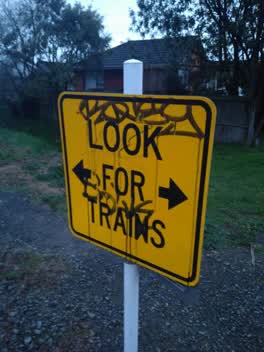 Graffiti —
 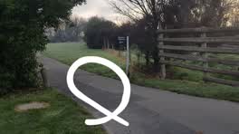 Parks —
 The vehicle barrier at the Sturrocks Rd entrance to Barnes Reserve has been left unlocked for weeks. I'm concerned about the safety hazard a
Also reported on Sturrocks Road
- 67 Sturrocks Road — 16 reports
- 72 Sturrocks Road — 6 reports
- 62 Sturrocks Road — 5 reports
- 59C Sturrocks Road — 5 reports
- 74 Sturrocks Road — 3 reports
- 103 Sturrocks Road — 3 reports
- 102 Sturrocks Road — 3 reports
- 92B Sturrocks Road — 2 reports
The street’s crash record
NZTA’s record names Sturrocks Road in 3 crashes that hurt somebody since 2006 — 2 seriously hurt, nobody killed.
The green nearby
- Barnes Reserve — you are in it · 2 ha
- Redwood Park — 24 m to the edge · Sports ground · 7 ha
- Marlene Reserve — 135 m to the edge
- Aylsham Reserve — 244 m to the edge
- Cavendish Stream Landscape Reserve — 402 m to the edge
Parks within half a kilometre, measured to the boundary — the council’s open data.
On the doorstep
- Redpath Electrical Supply — 81 m away · Electrical
- G. G. Don Plumbing, Roofing and Sheet Metal — 110 m away · Plumbers
- Papanui Redwood Association Football Club — 148 m away · Clubs
- National Library Christchurch — 197 m away · Government
Businesses within four hundred metres, measured at the pin — OpenStreetMap and the council directories.
The bus nearby
- Cavendish Rd near Sturrocks Rd — 352 m away · route 27
- Cavendish Rd near Barnes Rd — 371 m away · route 28
The closest Metro stops, within four hundred and fifty metres.
The tracks through here
- Walk and bike track through Casebrook — 1 m to the line · walk · bike
- Walk and bike track through Casebrook — 13 m to the line · walk · bike
- Walk and bike track through Casebrook — 14 m to the line · walk · bike
- Walk and bike track through Casebrook — 190 m to the line · walk · bike
- Walk and bike track through Casebrook — 249 m to the line · walk · bike
Tracks whose line passes within half a kilometre, measured to the line itself — the council’s open data.
The named ground
Named water within 500 m of this address, measured to the line or the edge; Named places within 1.5 km of this address; the council’s own structure register — bridges, boardwalks and steps standing nearby — the open map’s record.
Renting nearby
new bonds in Casebrook ran about $598 a week — $48 above the city median of $550 — the suburb page keeps the rent record →.
The civic layer
This ground votes in Harewood ward — the Fendalton-Waimairi-Harewood community board. Ward lines don’t always follow suburb lines; this one is measured at the pin, not the suburb’s centre.
What stood on this ground → · On the map → · From the air — the Crown’s aerials back to 1936; search the address on RetroLens →
Questions, answered briefly
24 council reports on record since August 2020 — most often graffiti (5), pavement - general (4), graffiti on a fence, building or structure (4).
Casebrook, Christchurch — on Sturrocks Road.
Nothing on the heritage register at this exact spot — the record around this ground →
Barnes Reserve — the address is inside it, 2 ha.