66 Colombo Street, Cashmere
56 reports on record since October 2015 · 36 with photographs. The most-reported address on Colombo Street. Indicative rating valuation and school zones, hazards, bin day and what stood here before.
What gets reported here
- Graffiti — 11
- Roading/Streets — 8
- Damaged Street Sign — 5
- Rubbish/Recycling — 4
- Hazard — vehicle — 4
- Parks — 3
Photographed here 36 on record




Reported here
- Facility - General Request —
hey team, hope you're having a fab week. I'm just messaging on behalf of Land Search and Rescue. We often run courses for our volunteers a
 Fallen Tree —
 Hi Broken branch hanging by a thread
 Water Fountain —
 Dog bowl growing things
 Hazard — vehicle —
 Freedom camping in CCC parking
 Hazard — vehicle —
 Freedom camping still being allowed in CCC car park
 Pavement - Damaged —
 Damaged guard rail blocking access to crossing point
 Hazard — vehicle —
 Freedom campers parked up in CCC Library parking
 Pavement - General —
 At South library there is a clear trip hazard from the framing on the desire line into the front door. Fix a yellow or orange hit post (fro
 Graffiti on a sign, mural or public art —
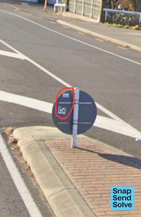
 Graffiti (stickers) on the rear face of blue circular “keep left” road sign on pedestrian refuge island on Colombo Street, Cashmere. The aff
 Poles and Signage - General —
 Keep left sign on pedestrian island has been knocked over
 Graffiti on a cabinet, pole or railway asset —
 Graffiti on roadside cabinet on Colombo Street, Cashmere (near intersection with Ernlea Terrace). The affected cabinet is on the opposite si
 Damaged Street Sign —
 Damaged blue “keep left” road sign on pedestrian refuge island on Colombo Street, Cashmere. The damaged sign is located on the island in the
 Graffiti on a cabinet, pole or railway asset —
 Graffiti on network utility box near corner of Ernlea Terrace and Colombo Street, Cashmere.
 Graffiti on a cabinet, pole or railway asset —
 Cnr Ernie’s the opposite library
 Road Signage —
 Signage down from pedestrian Island on Colombo St outside South Library
 Graffiti somewhere else —
  Graffiti somewhere else —
 Graffiti / yuck!
 Hazard — vehicle —
 Two weekends in a row seen the same BMW parked in no parking spot at South Library.
 Damaged Street Sign —
 This piece has been here for a least a week or so. Not sure where it comes from or where the rest is.
 Roads - General —
 The double angled arrows sign on the road crossing island on Colombo st outside the South library has been knocked out. It it lying under th
- Damaged Street Sign —
- Graffiti —
- Graffiti —
- Damaged Road —
- General Request —
- Graffiti —
- Graffiti —
- Graffiti —
- Graffiti —
- Damaged Street Sign —
- Facility - General Request —
- Damaged Street Sign —
- Accessibility —
- Pavement - General —
- Facility - General Request —
- Park - General Request —
 Roading/Streets —
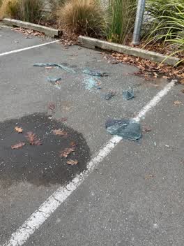
 Broken glass in South Library Carpark
 Parks —
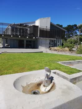
 North Beach drinking fountain is stuck on running. Has been for at least a month apparently.
- Roading/Streets —
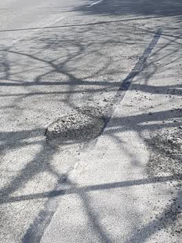
Large pothole entry to South Library. Colombo St end
 Rubbish/Recycling —
 Pot hole in road at entrance to South Library driveway. It's is right where cars drive so is getting bigger.
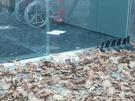 Rubbish/Recycling —
 not really rubbish but someone has left a puzzle outside the doors at south library
Parks —
tree down
Graffiti —
vagrant stoned on river bank Weimar tce close Colombo st
Graffiti —
under bridge
Rubbish/Recycling —
Rubbish/Recycling —
Lots of bins overflowing in South chch
Roading/Streets —
Potholes on that road by the library
Parks —
Wasp nest on roadside
Graffiti —
Roading/Streets —
This drain cover has been reported several times. It's in the middle of the car park road at Beckenham library, and needs to be fixed to avo
Roading/Streets —
Wondering why this stretch h of grass berm has not been mowed when the rest of the street has been sorted
Roading/Streets —
Freedom camper cpz64 Waimea tce outside library near Colombo st
- Roading/Streets —
Navy Toyota Francia cpz64 parked Colombo street end of Waimea the suspected freedom of camper
Graffiti —
Test snap
- Graffiti —
Roading/Streets —
Yellow road markings indicating P10 need repainting. Also could use P10 road sign in middle of p10 area as visibilty is broken by trees betw
Also reported on Colombo Street
- 70 Colombo Street — 27 reports
- 50 Colombo Street — 21 reports
- 27 Colombo Street — 16 reports
- 20 Colombo Street — 16 reports
- 52 Colombo Street — 13 reports
- 2 Colombo Street — 13 reports
- 62 Colombo Street — 11 reports
- 22 Colombo Street — 11 reports
The street’s crash record
NZTA’s record names Colombo Street in 30 crashes that hurt somebody since 2006 — 11 seriously hurt, nobody killed.
The green nearby
- Ernle Clark Reserve — 221 m to the edge · Botanic · 2 ha
- Waimea Reserve — 236 m to the edge
- Colombo Reserve — 387 m to the edge
- Thorrington Reserve — 408 m to the edge
- Beckenham Park — 499 m to the edge · Sports ground · 5 ha
Parks within half a kilometre, measured to the boundary — the council’s open data.
The civic shelf nearby
- South Christchurch Library — 6 m away · Library · 66 Colombo St, Cashmere, Christchurch 8022
- Beckenham Service Centre — 28 m away · Service centre
Libraries, halls and the rest within half a kilometre — the council’s open data.
On the doorstep
- Opawa Farmers' Market — 24 m away · Markets
- Novel Cafe Beckenham — 59 m away · Cafés
- Malthouse Costumes — 92 m away · Rental
- Canterbury Childrens Theatre — 99 m away · Cinemas & theatres
Businesses within four hundred metres, measured at the pin — OpenStreetMap and the council directories.
The bus nearby
The closest Metro stops, within four hundred and fifty metres.
The tracks through here
- Walk and bike track through Cashmere — 36 m to the line · walk · bike
- Walk and bike track through Cashmere — 47 m to the line · walk · bike
- Walk and bike track through Cashmere — 50 m to the line · walk · bike
- Walk and bike track through Cashmere — 65 m to the line · walk · bike
- Walk and bike track through Cashmere — 199 m to the line · walk · bike
Tracks whose line passes within half a kilometre, measured to the line itself — the council’s open data.
The named ground
Named water within 500 m of this address, measured to the line or the edge; the council’s own structure register — bridges, boardwalks and steps standing nearby — the open map’s record.
Renting nearby
new bonds in Cashmere ran about $707 a week — $157 above the city median of $550 — the suburb page keeps the rent record →.
What was here — The Malthouse and Setting
103 m away · 69 Colombo Street · located to ±21 m · the place’s own record →
On the register. Nothing researched here yet.
The civic layer
This ground votes in Cashmere ward — the Spreydon-Cashmere-Heathcote community board. Ward lines don’t always follow suburb lines; this one is measured at the pin, not the suburb’s centre.
What stood on this ground → · On the map → · From the air — the Crown’s aerials back to 1936; search the address on RetroLens →
Questions, answered briefly
56 council reports on record since October 2015 — most often graffiti (11), roading/streets (8), damaged street sign (5).
Cashmere, Christchurch — on Colombo Street.
The heritage register names a place at or beside it — The Malthouse and Setting.
Ernle Clark Reserve — 221 m to its edge, 2 ha.