520A Marine Drive
5 council reports since March 2022, 5 carrying a photograph. The most-reported address on Marine Drive.
From the air, then
Sourced from Canterbury Maps and partners. LINZ, CC BY 3.0 NZ. Each frame is cut from Environment Canterbury’s historic imagery MapServer for that decade, only where the Footprints layer names a CC BY survey (NZAM-covered spots stay out). RetroLens holds more Crown aerials →
On the doorstep
- Whistling Buoy, 281 m away · Bottle stores
Businesses within four hundred metres, measured at the pin, OpenStreetMap and the council directories.
The named ground
Named water within 500 m of this address, measured to the line or the edge; the council’s own structure register, bridges, boardwalks and steps standing nearby, the open map’s record.
What gets reported here
Photographed here 5 on record


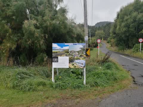
What’s on record
 Fallen Tree, 2 Sept 2026
there are 4 dead trees on the road reserve where the head to head walkway comes out onto marine drive near the corner of Anderson's road. A
 Damaged Street Sign, 20 Jun 2026
one speed limit sign has been rotated so that the 30 is not visible, the other has the circular sign removed. corner of Anderson's Rd and ma
 Damaged Street Sign, 13 Feb 2024
Wooden post displaying 30k speed sign has been snapped off at the base and needs replacing. Location is the corner of Marine Drive and Ander
 Flooding, 21 Jul 2022
Council drain is blocked and overflowing. It is threatening to flood our garage We are currently clearing it but it is generally always bloc
 Roading/Streets, 16 Mar 2022
Real estate sign doesn't meet bylaw requirements. Too big, obstructing view of traffic sign, not outside the business premises or the house
Elsewhere on Marine Drive
- 427 Marine Drive, 3 reports
- 518 Marine Drive, 2 reports
- 439 Marine Drive, 2 reports
- 426 Marine Drive, 2 reports
- 498 Marine Drive, 1 report
- 492 Marine Drive, 1 report
- 479 Marine Drive, 1 report
- 471 Marine Drive, 1 report
The civic layer
This ground votes in Banks Peninsula ward, the Banks Peninsula community board is its local layer. Ward lines don’t always follow suburb lines; this one is measured at the pin, not the suburb’s centre. The whole roll is at /wards.
Marine Drive, the whole record → · Everything about Charteris Bay → · What stood on this ground → · On the map → · From the air, RetroLens holds the Crown’s aerials back to 1936; search the address there →
Questions, answered briefly
5 council reports on record since March 2022, most often damaged street sign (2), roading/streets (1), flooding (1).
Charteris Bay, Christchurch, on Marine Drive.
Nothing on the heritage register at this exact spot, the record around this ground →