
Fallen Tree520A Marine Drive
there are 4 dead trees on the road reserve where the head to head walkway comes out onto marine drive near the corner of Anderson's road. A fifth dead tree…
67 council reports since August 2016, the 103rd busiest suburb in the city. 47 photographs on record. 129 people at the most recent Census.
The record also holds 2023 Census snapshot· 47 photographs· 2 old photographs· 3 heritage places· 40 documents· 3 mentions on the wire
Link-outs to the source’s own live pages, chch.live does not copy their live values or source text.
Rent: too few new bonds lodged here for Tenancy Services to publish a median this quarter, the last figure it released was about $575 a week, and it counts this under the much wider Diamond Harbour area, this locality sits inside it, so read the figure as the district’s.
Median and quartiles of weekly rents on new private bonds, by quarter. New bonds are fresh lodgements, not the whole rental stock; under five bonds the rent is withheld, and counts are randomly rounded. Source: Tenancy Services rental bond data: provisional while the bond system migrates.
Lately the record’s mostly roads & footpaths, 11 reports in the year to 12 October 2026, the newest 2 September 2026.
One for the quiz, Its busiest day on record was 20 June 2026, 3 reports in a single day.
About 1,536 people and 693 occupied private households in the “Diamond Harbour” and “Teddington” areas, grouped from 13 SA1 areas. A wider statistical area stands in for this suburb, so this is a proxy rather than a count for the suburb boundary.
Stats NZ’s 2023 Census uses fixed random rounding to base 3. Unavailable or confidential cells are left out, not treated as zero. individuals · households · geography · CC BY 4.0.
Charteris Bay is a small settlement on Banks Peninsula in New Zealand. The settlement is located on the south eastern side of Te Wharau / Charteris Bay, a large inlet of Lyttelton Harbour / Whakaraupō. The settlement sits between Diamond Harbour to the east and Teddington to the west.
Placed by the record’s locality join or the name in its own title, a lead, not a claim each frame stood here.
there are 4 dead trees on the road reserve where the head to head walkway comes out onto marine drive near the corner of Anderson's road. A fifth dead tree…

culvert under the road blocked by rocks at the harbour side, debris under the road, and vegetation on the other side of the road. in heavy rain, the drain…

Culvert completely blocked. opposite the windy road sign on Anderson's Rd. Result is that water runs down the road and onto 518 Marine drive when it rains…

one speed limit sign has been rotated so that the 30 is not visible, the other has the circular sign removed. corner of Anderson's Rd and marine drive
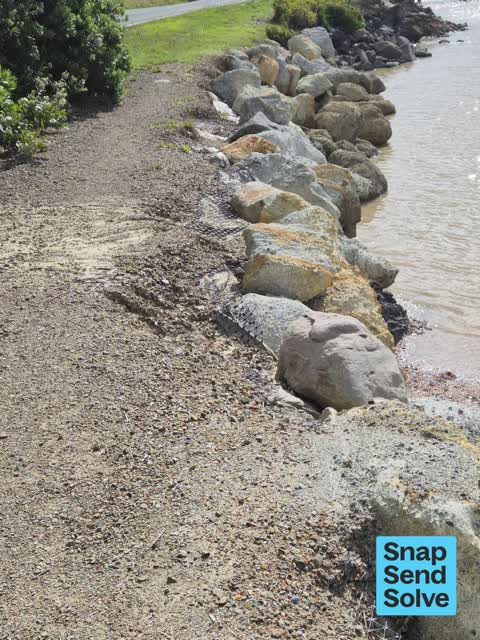
Hi, foreshore erosion, rocks becoming exposed on foreshore causing holes cud become hazardous. it is on a walkway away from the road near foreshore and it is…


Recently resurfaced road surface, very quickly deteriorated and now unsafe to drive on.
After having been sealed in the last two to three weeks, previous potholes are reappearing and new chip seal has been worn away in several places exposing…
Recently resurfacing on road has lifted. Loose gravel ++ Speed limit signs state 60kmph, but too fast for poor road condition. Very slippy, no grip, metal o…
Very dangerous corners. New seal has slumped and worked loose. One car has already gone over the edge. Car slides even when driven at suggested speed.

Theres been a slip. Tress pushed down the bank. Has been tidied up. But need more work. Vegetation is sitting on the wite live lane line.

This road was resealed less than a year ago and is now filled with temporary repairs again. What steps are being taken to hold the contractors to account for…
No boundary is on record for Charteris Bay, the joins that count inside an outline (the crash tally, the ground layers, the area figures) stay unanswered rather than guessed.
What the archive’s sources say about Charteris Bay, titled for it, turned up by a search for one of its places, or carrying its name in the text. These are leads and citations: the originals live at the provider, linked from each row.
…he starting point and numbered 123 on the chief surveyor map no 124 g h roive 50 acres in charteris bay port victoria the western side of the bay with sea frontage and bounded on the e by the creek ru…Lyttelton Times · Papers Past · National Library of New Zealand · · text held
…n of the clear annual value of 5 and six calendar months residence freeholder barton farm charteris bay and lease holder quail island port victoria freeholder rural section no 315 freeholder cluclteng…Lyttelton Times · Papers Past · National Library of New Zealand · · text held
…n of the clear annual value of 5 and six calendar months residence freeholder barton farm charteris bay and lease holder quail island port victoria freeholder rural section no 315 freeholder cluclteng…Lyttelton Times · Papers Past · National Library of New Zealand · · text held
unreserved sale by auction in charteris bay under a writ from the supreme court of new zealand messrs f noble campbell and co have received…Lyttelton Times · Papers Past · National Library of New Zealand · · text held
…rum teviot dale dr mccheane lvttelton j mr minchin christchurch mccormack sumner dr moore charteris bay mr j h moore ferry road augustus moore lincoln road norton papanui parkinson lyttelton c j perce…Lyttelton Times · Papers Past · National Library of New Zealand · · text held
…rum teviot dale dr mccheane lyttelton mr minchin christchurch mccormack sumner i dr moore charteris bay mr j h moore ferry road augustus moore lincoln road norton papanui v parkinson lyttelton c j per…Lyttelton Times · Papers Past · National Library of New Zealand · · text held
…ldrum teviot dale dr mccheane lyttelton mr minchin christehurch mccormack sumner dr moore charteris bay mr j h moore ferry road augustus moore lincoln road norton papanui parkinson lyttelton c j perce…Lyttelton Times · Papers Past · National Library of New Zealand · · text held
…the town of lyttelton at the corner of dublin street and norwich quay for 410 barton farm charteris bay containing 164 acres with buildings and improvements thereon was sold by private contract to mr…Lyttelton Times · Papers Past · National Library of New Zealand · · text held
…dington william christchurch stock owner fawcett james riccarton bricklayer fawcett peter charteris bay landholder fendall walpole c fendall town farmer fendall charles w fendall town farmer field str…Lyttelton Times · Papers Past · National Library of New Zealand · · text held
…1218 0 rubai lands island heathcote estuary 6 1076 o2 0 10 0 gibbie bay 6 1492 2 2 0 500 charteris bay 7 1587 9 0 0 18 0 0 prebbleton 8 1595 1 0 0 2 0 0 tai tapu 2 1596 5 ofo 10 0 0 rangipra 10 1621…Lyttelton Times · Papers Past · National Library of New Zealand · · text held
The rest are a search away, the whole shelf, for the name →
41 more documents came up in searches for Charteris Bay's places and have not been read yet, a lead is a search result, not a fact, until somebody reads it.
Compare Charteris Bay with Diamond Harbour · Purau · Corsair Bay · Governors Bay · Te Rapaki o Te Rakiwhakaputa · Rapaki, same record, side by side.
Charteris Bay is a small settlement on Banks Peninsula in New Zealand. The public record holds 67 council reports for it, the first filed in August 2016.
129 people at the the most recent count Census.
About 1,536 people and 693 occupied private households (wider SA2 stand-in): grouped from Stats NZ SA1 areas through this site’s suburb join. Indicative, not a LIM.
67 reports on record, most often roads & footpaths (48), trees & parks (9), water & drains (5). 11 of them in the year to 12 October 2026.
The heritage register holds 3 places here, Former Charteris Bay School and Setting, Millhouse and Setting among them. The written record goes back further: the shelf, for the name →
Every suburb in Christchurch → · Its decade, charted → · the whole A–Z →
Work orders, not the resident reports above, the council’s MyCouncilTicket stream, and one job can appear in both. A median counts only finished jobs; open ones are named as open, never averaged in. The ticket roll · the whole city’s fix times.
The council’s bylaw zones and the Local Alcohol Policy’s buffer list, read from the Regulatory open-data service. A ban rules drinking in public places; it says nothing about whether a premises may sell, that is the licence register’s job.
Ministry of Education directory, the final decile and the current Equity Index describe the community a school draws from, not how well it teaches. Zones are indicative; the written enrolment scheme rules.
Parks and reserves in the council’s open data, the park lands in the suburb its centre falls inside; one that straddles the line keeps its own address.
Libraries, halls, cemeteries and the rest in the council’s open data, a facility lands in the suburb its point or centre falls inside.
Places of worship in the open map’s record, one lands in the suburb its building stands in. The whole roll is at /worship.
Marae in the region’s roll, a marae stands where it stands; the join names the suburb the roll files it under. The whole roll is at /maraes.
Walking, biking, horse and off-road tracks in the council’s open data, a line belongs to every suburb it passes through.
OpenStreetMap’s own record, inside this outline, a pin is the mapper’s; a waterway belongs to every suburb it crosses. Every roll, counted: /geography.
Heritage places the council’s district plan or Heritage New Zealand list inside this suburb, each with what is known about it and the document it is known from.
The register’s era records for places in this suburb, what stood on the ground, and when.
Each of these is a decade of reports, the heritage places on the register, what is known about them, and the documents behind it, everything the archive holds about the part of the city it names.