1 New Regent Street, Christchurch Central City
14 reports on record since November 2019 · 9 with photographs. The most-reported address on New Regent Street. Indicative rating valuation and school zones, hazards, bin day and what stood here before.
What gets reported here
Photographed here 9 on record




Reported here
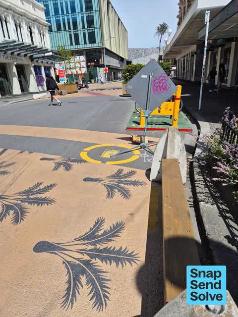
 Graffiti on a fence, building or structure —
multiple graffiti stickers on bike park signage structure
 Facility - General Request —
The planter box outside #1 New Regent St has been broken and the soil is falling out everywhere. The wood looks completely rotten.
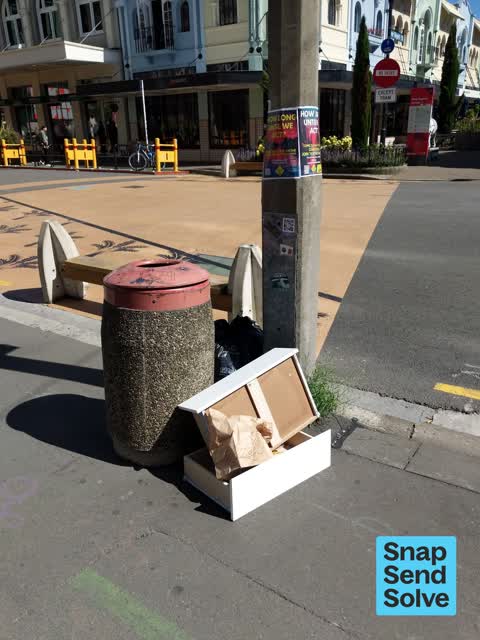
 Graffiti somewhere else —
On back of worker sign by bike stand at new regent Street
 Graffiti somewhere else —
Black utility box Gloucester St opposite New Regent Street by carpark
 Graffiti on a fence, building or structure —
 Graffiti —
 Dumped Rubbish —
Drawers and other rubbish
- Graffiti —
- Graffiti —
- Graffiti —
- Pavement - Damaged —
- Water Leak —
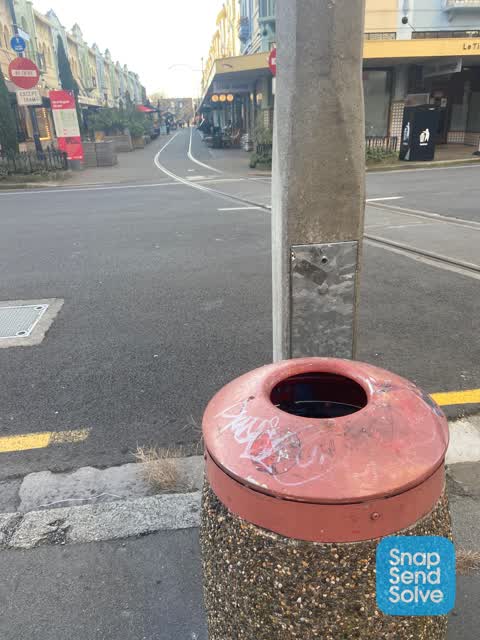
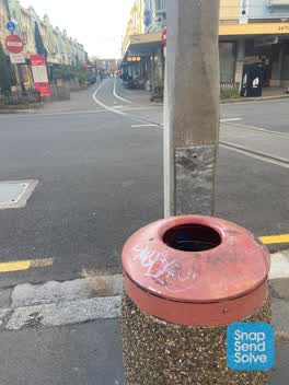 Graffiti —
Gray paint tag on red lid of rubbish bin on Gloucester Street opposite New Regent Street.
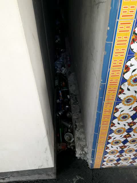
Rubbish/Recycling —
Also reported on New Regent Street
- 38 New Regent Street — 6 reports
- 3 New Regent Street — 5 reports
- 5 New Regent Street — 4 reports
- 4 New Regent Street — 4 reports
- 14 New Regent Street — 4 reports
- 12 New Regent Street — 4 reports
- 41 New Regent Street — 3 reports
- 39 New Regent Street — 2 reports
The street’s crash record
NZTA’s record names New Regent Street in 5 crashes that hurt somebody since 2006 — 2 seriously hurt, nobody killed.
The green nearby
- Cathedral Square — 141 m to the edge · Botanic
- Edmonds Band Rotunda — 199 m to the edge · Botanic
- Victoria Square — 210 m to the edge · Botanic · 2 ha
- Godley Statue Reserve — 233 m to the edge · Botanic
- Latimer Square — 285 m to the edge · Botanic · 2 ha
Parks within half a kilometre, measured to the boundary — the council’s open data.
The civic shelf nearby
- Turanga Library — 122 m away · Library · Cathedral Square, Christchurch
- Triangle — 357 m away · Car park
- Aldersgate — 477 m away · Car park
- Armagh St — 486 m away · Car park
Libraries, halls and the rest within half a kilometre — the council’s open data.
On the doorstep
- Francesca's Italian Kitchen — 10 m away · Restaurants
- Swiss Cafe — 11 m away · Restaurants
- Youngs Jewellers — 13 m away · Jewellery
- Coffee Corner — 15 m away · Cafés
Businesses within four hundred metres, measured at the pin — OpenStreetMap and the council directories.
The bus nearby
- Manchester St Super Stop — 144 m away · route 1, route 5, route 7, route 8, route 27, route 29, route 44, route 86, route 91, route 92, route 95
- Manchester St Super Stop — 193 m away · route 1, route 5, route 7, route 8, route 27, route 29, route 44, route 86, route 91, route 92, route 95
The closest Metro stops, within four hundred and fifty metres.
The tracks through here
- Walk and bike track through Christchurch Central City — 83 m to the line · walk · bike
- Walk and bike track through Christchurch Central City — 111 m to the line · walk · bike
- Walk and bike track through Christchurch Central City — 155 m to the line · walk · bike
- Walk and bike track through Christchurch Central City — 210 m to the line · walk · bike
- Walk and bike track through Christchurch Central City — 301 m to the line · walk · bike
Tracks whose line passes within half a kilometre, measured to the line itself — the council’s open data.
The named ground
Named water within 500 m of this address, measured to the line or the edge; Named places within 1.5 km of this address; the council’s own structure register — bridges, boardwalks and steps standing nearby — the open map’s record.
The remembered names nearby
- In Memory of / Jaime Robert McDowell Gilbert — 102 m away ·
IN MEMORY OF / JAIME ROBERT MCDOWELL GILBERT / WHO LOST HIS LIFE / AT THIS LOCATION IN THE
· 2018 - Godley Statue Reserve plaque — 130 m away · 1899
- Godley Statue Reserve plaque — 131 m away · 1899
Inscribed plaques within two hundred and fifty metres — the register’s pins, not surveyed spots. The whole roll is at /plaques.
Renting nearby
new bonds in Christchurch Central City ran about $508 a week — $42 below the city median of $550 — the suburb page keeps the rent record →.
What was here — Theatre Royal Façade, Dome, Staircase and Setting
41 m away · 145 Gloucester Street · located to ±24 m · the place’s own record →
On the register. Nothing researched here yet.
What was here — New Regent Street Shops and Setting
on this spot · 17 New Regent Street · located to ±48 m · the place’s own record →
On the register. Nothing researched here yet.
What was here — Commercial Building Façade and Setting, Former A W Smith and Son's Central Garage/Mayfair-Cinerama Theatre
121 m away · 115A Worcester Street · located to ±12 m · the place’s own record →
On the register. Nothing researched here yet.
What was here — Former Government Buildings and Setting
154 m away · 26/28 Cathedral Square · located to ±43 m · the place’s own record →
On the register. Nothing researched here yet.
What was here — Commercial Building and Setting, Former State Insurance
171 m away · 58/28 Cathedral Square · located to ±28 m · the place’s own record →
On the register. Nothing researched here yet.
The civic layer
This ground votes in Central ward — the Papanui-Innes-Central community board. Ward lines don’t always follow suburb lines; this one is measured at the pin, not the suburb’s centre.
What stood on this ground → · On the map → · From the air — the Crown’s aerials back to 1936; search the address on RetroLens →
Questions, answered briefly
14 council reports on record since November 2019 — most often graffiti (5), graffiti somewhere else (2), graffiti on a fence, building or structure (2).
Christchurch Central City, Christchurch — on New Regent Street.
The heritage register names 5 places at or beside it — Theatre Royal Façade, Dome, Staircase and Setting, New Regent Street Shops and Setting.
Cathedral Square — 141 m to its edge.