140A Barbadoes Street, Christchurch Central City
17 reports on record since April 2022 · 12 with photographs. The street’s heaviest record is 390 Barbadoes Street, 65 reports on file. Indicative rating valuation and school zones, hazards, bin day and what stood here before.
What gets reported here
Photographed here 12 on record


Reported here
 Graffiti on a fence, building or structure,
graffiti on red brick fence
 Graffiti on a fence, building or structure,
graffiti on one way signage post pole
 Pavement - Damaged,
a large pot hole on footpath, entrance to the mainland carpark opposite Ara
 Graffiti on a sign, mural or public art,
Graffiti on sign board
 Graffiti on a sign, mural or public art,
Small yellow graffiti on parking sign on Barbadoes Street
 Graffiti on a traffic light pole or cabinet, or wa,
Graffiti on light pole just outthe ARA campus entry gate 1
 Graffiti on a fence, building or structure,
Still more paint tags on wooden planter box by 140a Barbadoes Street facing the footpath.
 Graffiti on a fence, building or structure,
On piller to catholic cathedral car park. More on road side
 Graffiti on a cabinet, pole or railway asset,
White paint tag on metal lamp pole on Barbadoes Street opposite Coventry Street.
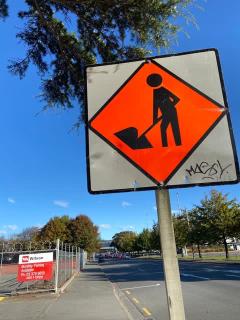
 Graffiti on a sign, mural or public art,
Crimson paint tag on reverse side of 30 sign by 140 Barbadoes Street.
 Graffiti on a cabinet, pole or railway asset,
Blue paint tag on metal lamp pole on Barbadoes Street opposite Coventry Street.
- Animal - Deceased,
- Graffiti,
- Graffiti,
- Graffiti,
- Graffiti,
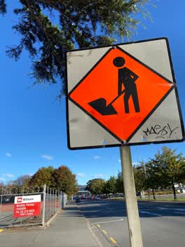 Graffiti,
MAGSY black paint tag on men at work sign by 140 Barbadoes Street.
Also reported on Barbadoes Street
- 390 Barbadoes Street, 65 reports
- 259 Barbadoes Street, 51 reports
- 384 Barbadoes Street, 47 reports
- 321 Barbadoes Street, 37 reports
- 377 Barbadoes Street, 36 reports
- 288 Barbadoes Street, 29 reports
- 407 Barbadoes Street, 28 reports
- 324 Barbadoes Street, 28 reports
From the air, then
Sourced from Canterbury Maps and partners. LINZ, CC BY 3.0 NZ. Each frame is cut from Environment Canterbury’s historic imagery MapServer for that decade, only where the Footprints layer names a CC BY survey (NZAM-covered spots stay out). RetroLens holds more Crown aerials →
The street’s crash record
NZTA’s record names Barbadoes Street in 215 crashes that hurt somebody since 2006, 1 person killed, 31 seriously hurt.
The green nearby
- Wilson Park, 196 m to the edge
- Washington Way Reserve, 242 m to the edge · Sports ground
- Gasson Reserve, 362 m to the edge
- Science Alive Reserve, 428 m to the edge
Parks within half a kilometre, measured to the boundary, the council’s open data.
The civic shelf nearby
- St Asaph, 268 m away · Car park
Libraries, halls and the rest within half a kilometre, the council’s open data.
On the doorstep
- Workspace Studios - Christchurch, 109 m away · Jewellers
- NZ Safety Blackwoods, 110 m away · Clothing
- ARA Health Centre, 113 m away · Doctors & clinics
- Seido Karate, 134 m away · Sports centres
Businesses within four hundred metres, measured at the pin: OpenStreetMap and the council directories.
The bus nearby
- St Asaph St near Barbadoes St, 175 m away · route 80
- Ara Institute, 184 m away · route 1, route 3, route 5, route 80, route 81
The closest Metro stops, within four hundred and fifty metres.
The tracks through here
- Walk and bike track through Christchurch Central City, 90 m to the line · walk · bike
- Walk and bike track through Christchurch Central City, 221 m to the line · walk · bike
- Walk and bike track through Christchurch Central City, 221 m to the line · walk · bike
- Walk and bike track through Christchurch Central City, 221 m to the line · walk · bike
- Walk and bike track through Christchurch Central City, 296 m to the line · walk · bike
Tracks whose line passes within half a kilometre, measured to the line itself, the council’s open data.
The named ground
Named places within 1.5 km of this address; the council’s own structure register, bridges, boardwalks and steps standing nearby, the open map’s record.
Renting nearby
new bonds in Christchurch Central City ran about $508 a week, $42 below the city median of $550, the suburb page keeps the rent record →.
What was here, 319 St Asaph Street
210 m away · 319 St Asaph Street · located to ±21 m · the place’s own record →
On the register. Nothing researched here yet.
The civic layer
This ground votes in Central ward, the Papanui-Innes-Central community board. Ward lines don’t always follow suburb lines; this one is measured at the pin, not the suburb’s centre.
What stood on this ground → · On the map → · From the air, the Crown’s aerials back to 1936; search the address on RetroLens →
Questions, answered briefly
17 council reports on record since April 2022, most often graffiti (5), graffiti on a fence, building or structure (4), graffiti on a sign, mural or public art (3).
Christchurch Central City, Christchurch, on Barbadoes Street.
The heritage register names a place at or beside it, 319 St Asaph Street.
Wilson Park, 196 m to its edge.