17 Willow Street, Christchurch Central City
16 reports on record since September 2020 · 16 with photographs. The most-reported address on Willow Street. Indicative rating valuation and school zones, hazards, bin day and what stood here before.
What gets reported here
Photographed here 16 on record


Reported here
 Graffiti on a traffic light pole or cabinet, or wa —
 Thank you!
 Graffiti on a fence, building or structure —
 TY!
 Graffiti on a fence, building or structure —
 Thank you!
 Graffiti on a fence, building or structure —
 Thank you!
 Graffiti on a fence, building or structure —
 Thank you!
 Graffiti on a fence, building or structure —
  Graffiti on a fence, building or structure —
  Graffiti on a fence, building or structure —
  Graffiti on a fence, building or structure —
  Graffiti somewhere else —
  Graffiti somewhere else —
  Graffiti somewhere else —
 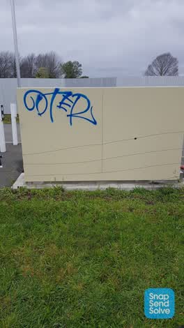 Graffiti —
 Parks —
Hole in fence
Graffiti —
There is fresh tagging in this area.
Graffiti —
There is fresh tagging all over the corrugated fencing and the switchboard near this address.
Also reported on Willow Street
- 20 Willow Street — 16 reports
- 11 Willow Street — 10 reports
- 7 Willow Street — 9 reports
- 1 Willow Street — 8 reports
- 19 Willow Street — 6 reports
- 13 Willow Street — 4 reports
- 15 Willow Street — 2 reports
- 21 Willow Street — 1 report
The green nearby
- Walnut Tree Park — 54 m to the edge
- Avon Riverbank Central City — 64 m to the edge · 6 ha
- Cambridge Green — 137 m to the edge
- Barbadoes Cemetery — 139 m to the edge · Botanic · 3 ha
- Moa Reserve — 324 m to the edge
Parks within half a kilometre, measured to the boundary — the council’s open data.
On the doorstep
- Christchurch Bridge Club — 200 m away · Clubs
- Boteco Cafe & Restaurant — 301 m away · Restaurants
- Gourmet Grub Food Truck — 301 m away · Fast food
- Coco Espresso — 305 m away · Cafés
Businesses within four hundred metres, measured at the pin — OpenStreetMap and the council directories.
The bus nearby
- Fitzgerald Ave near Alexandra St — 230 m away · route 7
- Fitzgerald Ave near River Rd — 272 m away · route 7
The closest Metro stops, within four hundred and fifty metres.
The tracks through here
- Walk and bike track through Christchurch Central City — 132 m to the line · walk · bike
- Walk and bike track through Christchurch Central City — 134 m to the line · walk · bike
- Walk and bike track through Christchurch Central City — 246 m to the line · walk · bike
- Walk and bike track through Christchurch Central City — 246 m to the line · walk · bike
- Walk and bike track through Christchurch Central City — 268 m to the line · walk · bike
Tracks whose line passes within half a kilometre, measured to the line itself — the council’s open data.
The named ground
Named water within 500 m of this address, measured to the line or the edge; Named places within 1.5 km of this address; the council’s own structure register — bridges, boardwalks and steps standing nearby — the open map’s record.
The remembered names nearby
- Barbadoes Cemetery plaque — 179 m away · 2003
Inscribed plaques within two hundred and fifty metres — the register’s pins, not surveyed spots. The whole roll is at /plaques.
Renting nearby
new bonds in Christchurch Central City ran about $508 a week — $42 below the city median of $550 — the suburb page keeps the rent record →.
What was here — Bangor Street No. 3 Pumphouse and Setting
126 m away · located to ±4 m · the place’s own record →
On the register. Nothing researched here yet.
What was here — Barbadoes Street Cemetery and Setting
on this spot · located to ±198 m · the place’s own record →
Barbadoes Street Cemetery's burial record runs in three Church of England registers: No. 1 from 9 April 1851 to 29 January 1870, No. 2 from 2 February 1870 to 3 September 1882, and No. 3 from 4 September 1882 into the 1970s.
Barbadoes Street Cemetery : alphabetical list of burials · · Christchurch City LibrariesEach register entry records when the person was buried, their name and surname, age, sex, parents' or husband's name, rank or profession, place of residence, and who performed the ceremony.
Barbadoes St Cemetery, Church of England, Register no. 1 · · Christchurch City LibrariesThe cemetery's ground was surveyed in nine historical plot plans, block by block — bordered by Barbadoes Street to the west and Cambridge Terrace to the south and east — and the plots are not consistently numbered; beside the lych-gate in block 3A, plot 780a is noted as apparently infant graves.
Barbadoes St Cemetery plan - area 1B · · Christchurch City LibrariesThe plots were sold: a separate burial plots book keeps receipt numbers, purchasers' names, plot numbers and sizes, and amounts paid, and its later pages record deposits on part-purchased plots, the completed purchase, and when title was given.
Barbadoes Street. Burial plots book · · Christchurch City LibrariesBy 1945 the cemetery sat inside a built-up city — a view across its headstones that year shows residential houses over the back fence — and by 1979 its graves and headstones were weathered, broken or fallen over; headstones still stood in the western portion in 2005.
Barbadoes Street Cemetery headstones · · Christchurch City LibrariesWhat was here — Dwelling and Setting
176 m away · 361 Cambridge Terrace · located to ±10 m · the place’s own record →
On the register. Nothing researched here yet.
The civic layer
This ground votes in Central ward — the Papanui-Innes-Central community board. Ward lines don’t always follow suburb lines; this one is measured at the pin, not the suburb’s centre.
What stood on this ground → · On the map → · From the air — the Crown’s aerials back to 1936; search the address on RetroLens →
Questions, answered briefly
16 council reports on record since September 2020 — most often graffiti on a fence, building or structure (8), graffiti somewhere else (3), graffiti (3).
Christchurch Central City, Christchurch — on Willow Street.
The heritage register names 3 places at or beside it — Bangor Street No. 3 Pumphouse and Setting, Barbadoes Street Cemetery and Setting.
Walnut Tree Park — 54 m to its edge.