237 Salisbury St Christchurch 8013 Canterbury New Zealand
1 council report since July 2022, 1 carrying a photograph.
On the register here
- The Bricks Site, Cairn and Setting, 311 Oxford Terrace (167m)
The green nearby
- Moa Reserve, 129 m to the edge · playground, 18 pieces
- Cambridge Green, 149 m to the edge
- Barbadoes Cemetery, 151 m to the edge · Botanic · 3 ha
- Avon Riverbank Central City, 182 m to the edge · 6 ha
- Fire Fighters Reserve, 261 m to the edge
Parks within half a kilometre, measured to the boundary, the council’s open data. The whole roll is at /parks.
On the doorstep
- Coffee Cafe, 117 m away · Fast food
- The Salisbury Hotel, 127 m away · Hotels
- Fox and Associates, 194 m away · Surveyors
- South Architects, 200 m away · Architects
Businesses within four hundred metres, measured at the pin, OpenStreetMap and the council directories.
The bus nearby
- Manchester St near Salisbury St, 341 m away · route 1, route 27, route 29, route 44, route 95
- Manchester St near Salisbury St, 354 m away · route 44
The closest Metro stops, within four hundred and fifty metres.
The tracks through here
- Walk and bike track through Christchurch Central City, 98 m to the line · walk · bike
- Walk and bike track through Christchurch Central City, 177 m to the line · walk · bike
- Walk and bike track through Christchurch Central City, 181 m to the line · walk · bike
- Walk and bike track through Christchurch Central City, 188 m to the line · walk · bike
- Walk and bike track through Christchurch Central City, 249 m to the line · walk · bike
Tracks whose line passes within half a kilometre, the council’s open data.
The named ground
Named water within 500 m of this address, measured to the line or the edge; Named places within 1.5 km of this address; the council’s own structure register, bridges, boardwalks and steps standing nearby, the open map’s record.
The remembered names nearby
- This Cairn / Marks the Site / of the / Brick Wharf, 167 m away ·
THIS CAIRN / MARKS THE SITE / OF THE / BRICK WHARF / WHERE THE / EARLY SETTLER / LANDED 18
- Plaque no. 310899, 199 m away
- Plaque no. 310900, 199 m away
Inscribed plaques within two hundred and fifty metres, the register’s pins, not surveyed spots. The whole roll is at /plaques.
Renting nearby
new bonds in Christchurch Central City ran about $508 a week, $42 below the city median of $550, the suburb page keeps the rent record →.
What gets reported here
- Graffiti, 1
Photographed here 1 on record
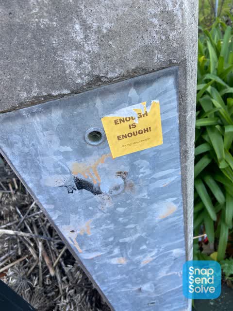
What’s on record
 Graffiti, 5 Jul 2022
Anti vax misinformation sticky tag on concrete lamp pole by 237 Salisbury Street needs removal.
The civic layer
This ground votes in Central ward, the Papanui-Innes-Central community board is its local layer. Ward lines don’t always follow suburb lines; this one is measured at the pin, not the suburb’s centre. The whole roll is at /wards.
Salisbury St Christchurch 8013 Canterbury New Zealand, the whole record → · Everything about Christchurch Central City → · What stood on this ground → · On the map → · Street View → · From the air, RetroLens holds the Crown’s aerials back to 1936; search the address there →
Questions, answered briefly
1 council report on record since July 2022, most often graffiti (1).
Christchurch Central City, Christchurch, on Salisbury St Christchurch 8013 Canterbury New Zealand.
The heritage register names a place at or beside it, The Bricks Site, Cairn and Setting.
Moa Reserve, 129 m to its edge.