310 Cambridge Terrace, Christchurch Central City
34 reports on record since April 2022 · 23 with photographs. The street’s heaviest record is 2 Cambridge Terrace — 251 reports on file. Indicative rating valuation and school zones, hazards, bin day and what stood here before.
What gets reported here
- Graffiti — 6
- Hazard — vehicle — 5
- Graffiti somewhere else — 3
- Facility - General Request — 3
- Graffiti on a sign, mural or public art — 2
- Graffiti on a road, footpath or bridge — 2
Photographed here 23 on record


Reported here
 Poles and Signage - General —
Stolen plaque
 Graffiti on a sign, mural or public art —
It appears a plaque has been removed that is under the tree. I dont know anything more than this. I noted the concrete with 2 holes. I assum
 General Request —
Stolen plaque
 Graffiti on a traffic light pole or cabinet, or wa —
Graffiti on a heritage lamp post. This has been reported numerous times but nothing is done so they keep adding to it. Please please please
 Overgrown Vegetation —
Overgrown riverbank
 Hazard — vehicle —
car parked on footpath by yellow parking lines
 Facility - General Request —
Plaque for tree is missing
 Graffiti on a fence, building or structure —
Bridge graffiti
 Graffiti on a sign, mural or public art —
Likely bronze plaque been stolen!
 General Request —
Road sign pole needs removal from the verge at the east end of the River Avon bridge on Kilmore Street.
 Graffiti on a cabinet, pole or railway asset —
ET black paint tag on concrete lamp pole by the River Avon bridge near 310 Cambridge Terrace.
 Hazard — vehicle —
Heaps of workers parking illegally obstructing footpaths
 Facility - General Request —
This brass plaque has been stolen or removed and the concrete plinth looks to have been moved. This was for the tree planted
 Graffiti somewhere else —
Graffiti on lamp pole next to bridge
 Graffiti somewhere else —
 Graffiti somewhere else —
Bridge has graffiti on it
 Graffiti on a road, footpath or bridge —
 Dumped Rubbish —
 Graffiti on a road, footpath or bridge —
Black graffiti on end of bridge (concrete support).
 Graffiti on a fence, building or structure —
 Fallen Tree —
Part of the willow tree opp 315 Cambridge Tce has fallen into the river and needs removal ??
 Facility - General Request —
Fallen tree acoss river down from kilmore st bridge
- Fallen Tree —
- Hazard — vehicle —
- Graffiti —
- Damaged Street Light —
- Graffiti —
- Graffiti —
- Hazard — vehicle —
- Sewer General —
- Graffiti —
- Graffiti —
- Hazard — vehicle —
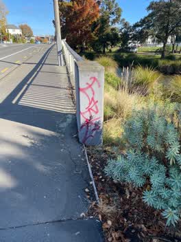 Graffiti —
Graffiti on Kilmore street bridge near fire station
Also reported on Cambridge Terrace
- 2 Cambridge Terrace — 251 reports
- 357 Cambridge Terrace — 116 reports
- 88 Cambridge Terrace — 92 reports
- 351 Cambridge Terrace — 81 reports
- 129 Cambridge Terrace — 80 reports
- 343 Cambridge Terrace — 79 reports
- 230 Cambridge Terrace — 74 reports
- 131 Cambridge Terrace — 72 reports
The street’s crash record
NZTA’s record names Cambridge Terrace in 44 crashes that hurt somebody since 2006 — 11 seriously hurt, nobody killed.
The green nearby
- Fire Fighters Reserve — 47 m to the edge
- Cambridge Reserve — 114 m to the edge
- Poplars Reserve — 135 m to the edge · Botanic
- Avon Riverbank Central City — 196 m to the edge · 6 ha
- Cambridge Green — 210 m to the edge
Parks within half a kilometre, measured to the boundary — the council’s open data.
On the doorstep
- Foley Towers — 89 m away · Hostels
- The Herb Centre Cafe — 111 m away · Cafés
- Street Bowls Vegan & GF Food Truck — 121 m away · Fast food
- Piko Whole Foods — 125 m away · Dairies & convenience
Businesses within four hundred metres, measured at the pin — OpenStreetMap and the council directories.
The bus nearby
- Manchester St near Kilmore St — 332 m away · route 1, route 27, route 29, route 44, route 91, route 92, route 95
- Manchester St near Kilmore St — 342 m away · route 44, route 91, route 92
The closest Metro stops, within four hundred and fifty metres.
The tracks through here
- Walk and bike track through Christchurch Central City — 26 m to the line · walk · bike
- Walk and bike track through Christchurch Central City — 26 m to the line · walk · bike
- Walk and bike track through Christchurch Central City — 26 m to the line · walk · bike
- Walk and bike track through Christchurch Central City — 72 m to the line · walk · bike
- Walk and bike track through Christchurch Central City — 81 m to the line · walk · bike
Tracks whose line passes within half a kilometre, measured to the line itself — the council’s open data.
The named ground
Named water within 500 m of this address, measured to the line or the edge; Named places within 1.5 km of this address; the council’s own structure register — bridges, boardwalks and steps standing nearby — the open map’s record.
The remembered names nearby
- Christchurch City Council 1969 H2o – Sig – T16 — 54 m away ·
CHRISTCHURCH CITY COUNCIL 1969 H2O – SIG – T16
· 2009 - Plaque no. 310899 — 57 m away
- Plaque no. 310900 — 57 m away
Inscribed plaques within two hundred and fifty metres — the register’s pins, not surveyed spots. The whole roll is at /plaques.
Renting nearby
new bonds in Christchurch Central City ran about $508 a week — $42 below the city median of $550 — the suburb page keeps the rent record →.
What was here — The Bricks Site, Cairn and Setting
147 m away · 311 Oxford Terrace · located to ±35 m · the place’s own record →
On the register. Nothing researched here yet.
What was here — Commercial Building and Setting
166 m away · 228 Kilmore Street · located to ±11 m · the place’s own record →
On the register. Nothing researched here yet.
What was here — Dwellings and Setting
180 m away · 100 Chester Street East · located to ±13 m · the place’s own record →
On the register. Nothing researched here yet.
What was here — Edmonds Clock Tower, Telephone Cabinet and Setting
180 m away · 295F Madras Street · located to ±15 m · the place’s own record →
On the register. Nothing researched here yet.
What was here — Dwellings and Setting
195 m away · 86 Chester Street East · located to ±15 m · the place’s own record →
On the register. Nothing researched here yet.
The civic layer
This ground votes in Central ward — the Papanui-Innes-Central community board. Ward lines don’t always follow suburb lines; this one is measured at the pin, not the suburb’s centre.
What stood on this ground → · On the map → · From the air — the Crown’s aerials back to 1936; search the address on RetroLens →
Questions, answered briefly
34 council reports on record since April 2022 — most often graffiti (6), hazard — vehicle (5), graffiti somewhere else (3).
Christchurch Central City, Christchurch — on Cambridge Terrace.
The heritage register names 5 places at or beside it — The Bricks Site, Cairn and Setting, Commercial Building and Setting.
Fire Fighters Reserve — 47 m to its edge.