5 Lava Lane, Christchurch Central City
22 reports on record since May 2024 · 22 with photographs. The most-reported address on Lava Lane. Indicative rating valuation and school zones, hazards, bin day and what stood here before.
What gets reported here
Photographed here 22 on record




Reported here
 Graffiti on a sign, mural or public art —
 Frequent graffiti offenders down here. Especially the Arise tag. The art billboards are bad enough that they should just be removed. Graffit
 Graffiti on a fence, building or structure —
 graffitti
 Graffiti on a sign, mural or public art —
  Hazard — vehicle —
 The lane is being utilized more and more for parking regardless of the Council signage. it's becoming more dangerous.
 Graffiti on a fence, building or structure —
  Pavement - General —
 damaged bollard seat douth frame
 Graffiti on a sign, mural or public art —
  Graffiti on a fence, building or structure —
 see photo. looks awful ??
 Roads - General —
 there really need to be something to slow the traffic down on Lava Lane as it intersects with Kahikatea Common. The speed that too many vehi
 Graffiti on a fence, building or structure —
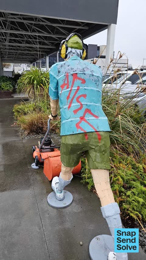
 Cacher ogc mower.on sulpture pulled away as well, i pushed it back into place but will need to be re attached
 Graffiti on a fence, building or structure —
  Pavement - General —
 Asked by public to fix this cover , upside down now but if right way round it doesn't sit right and you'd go through it if stepped on
 Street Gutters / Storm Water —
 This storm water drain is very hazardous. Someone could easily break a leg standing on the side of it. The lid is juts sitting there above a
 Graffiti somewhere else —
  Graffiti somewhere else —
  Graffiti on a sign, mural or public art —
 Lots more along here.
 Graffiti somewhere else —
  General Request —
 Reduced to clear trolly.
 Graffiti on a fence, building or structure —
 Central city team tried to remove
 Graffiti on a fence, building or structure —
 Various graffiti around Kahikatea Common and Lava Lane
 Graffiti on a fence, building or structure —
  Vandalism - General —
 Pump house
Also reported on Lava Lane
- 3 Lava Lane — 3 reports
The green nearby
- Tiffany Reserve — 194 m to the edge
- Friendship Corner — 251 m to the edge · Botanic
- Bridge Of Remembrance — 311 m to the edge · Botanic
- City Mall — 495 m to the edge
Parks within half a kilometre, measured to the boundary — the council’s open data.
The civic shelf nearby
- Scales — 282 m away · Car park
- Re:start - Lichfield St — 366 m away · Car park
- Civic Offices — 455 m away · Council office
Libraries, halls and the rest within half a kilometre — the council’s open data.
On the doorstep
- Euromarque CMG Motors — 76 m away · Car dealers
- Apartment Coffee — 78 m away · Cafés
- PB Tech — 92 m away · Computers
- CMG Motors — 94 m away · Car dealers
Businesses within four hundred metres, measured at the pin — OpenStreetMap and the council directories.
The bus nearby
- St Asaph St near Montreal St — 150 m away · route 3, route 5, route 7, route 60, route 80, route 81, route 84, route 85, route 86
- St Asaph St near Colombo St — 318 m away · route 3, route 5, route 7, route 60, route 80, route 81, route 84, route 85, route 86
The closest Metro stops, within four hundred and fifty metres.
The tracks through here
- Walk and bike track through Christchurch Central City — 62 m to the line · walk · bike
- Walk and bike track through Christchurch Central City — 237 m to the line · walk · bike
- Walk and bike track through Christchurch Central City — 249 m to the line · walk · bike
- Walk and bike track through Christchurch Central City — 284 m to the line · walk · bike
- Walk and bike track through Christchurch Central City — 341 m to the line · walk · bike
Tracks whose line passes within half a kilometre, measured to the line itself — the council’s open data.
The named ground
Named water within 500 m of this address, measured to the line or the edge; Named places within 1.5 km of this address; the council’s own structure register — bridges, boardwalks and steps standing nearby — the open map’s record.
Renting nearby
new bonds in Christchurch Central City ran about $508 a week — $42 below the city median of $550 — the suburb page keeps the rent record →.
What was here — St Michael's School Hall and Setting
154 m away · 243 Durham Street South · located to ±14 m · the place’s own record →
On the register. Nothing researched here yet.
What was here — St Michael's School Stone Building and Setting
165 m away · located to ±16 m · the place’s own record →
On the register. Nothing researched here yet.
What was here — St. Michael and All Angels Church & Setting
179 m away · 90 Oxford Terrace · located to ±25 m · the place’s own record →
On the register. Nothing researched here yet.
What was here — St Michael and All Angels Church Belfry and Setting
185 m away · 90 Oxford Terrace · located to ±5 m · the place’s own record →
On the register. Nothing researched here yet.
What was here — Rhododendron Island and Setting
215 m away · 78 Cambridge Terrace · located to ±37 m · the place’s own record →
On the register. Nothing researched here yet.
The civic layer
This ground votes in Central ward — the Papanui-Innes-Central community board. Ward lines don’t always follow suburb lines; this one is measured at the pin, not the suburb’s centre.
What stood on this ground → · On the map → · From the air — the Crown’s aerials back to 1936; search the address on RetroLens →
Questions, answered briefly
22 council reports on record since May 2024 — most often graffiti on a fence, building or structure (8), graffiti on a sign, mural or public art (4), graffiti somewhere else (3).
Christchurch Central City, Christchurch — on Lava Lane.
The heritage register names 5 places at or beside it — St Michael's School Hall and Setting, St Michael's School Stone Building and Setting.
Tiffany Reserve — 194 m to its edge.