628 Colombo Street, Christchurch Central City
17 reports on record since November 2019 · 13 with photographs. The street’s heaviest record is 794 Colombo Street — 159 reports on file. Indicative rating valuation and school zones, hazards, bin day and what stood here before.
What gets reported here
Photographed here 13 on record


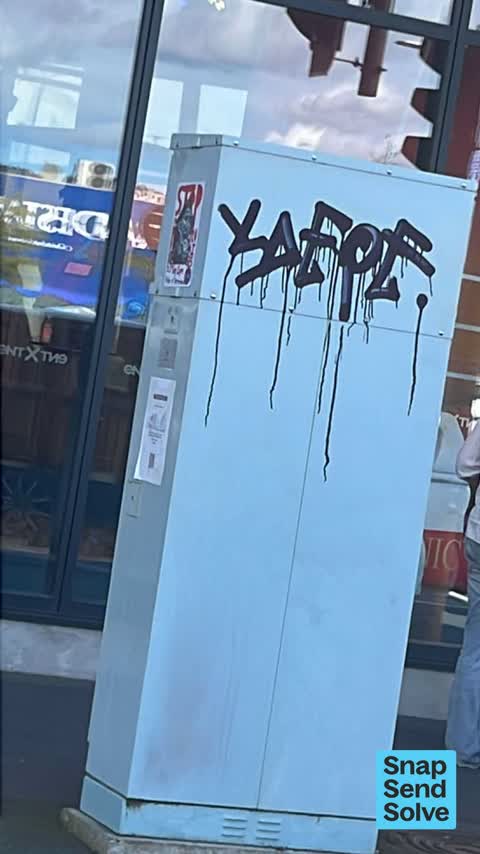

Reported here
 Graffiti on a fence, building or structure —
Graffiti inside Bus interchange on platform A by door 2 waiting area attached photo
 Graffiti on a bus stop or public toilet —
Offensive scratch graffiti. Toilet Roll Holder - Christchurch Bus Interchange - Tuam St-side toilets, stall 7.
 Graffiti on a fence, building or structure —
graffiti and etching on anti graffiti film.
 Graffiti on a bus stop or public toilet —
Potential harassment. Stall door, first stall on the right as you walk past the sliding doors. Deleting image after submitting.
 Pavement - Damaged —
Service cover smashed.
 Pavement - Damaged —
Damaged footpath needs repair on Colombo Street corner of Tuam Street. OHS risk to pedestrians at present.
 Damaged Road —
Broken tiles just outside of bus exchange building. Danger to pedestrian
 Pavement - Damaged —
 Pavement - Damaged —
 Pavement - General —
Broken snap glass outside Entex.
 Graffiti somewhere else —
 Road Signage —
Sign gone
- Pavement - General —
- Street Light Outage —
- Facility - General Request —
- Graffiti —
Graffiti —
carpark opposite Arcadia
Also reported on Colombo Street
- 794 Colombo Street — 159 reports
- 673 Colombo Street — 102 reports
- 781 Colombo Street — 55 reports
- 521 Colombo Street — 46 reports
- 722 Colombo Street — 45 reports
- 569 Colombo Street — 45 reports
- 527 Colombo Street — 41 reports
- 711 Colombo Street — 38 reports
The street’s crash record
NZTA’s record names Colombo Street in 177 crashes that hurt somebody since 2006 — 1 person killed, 32 seriously hurt.
The green nearby
- City Mall — 217 m to the edge
- High Street Triangles — 246 m to the edge
- Excelsior Hotel Reserve — 251 m to the edge · Botanic
- Friendship Corner — 296 m to the edge · Botanic
- The Stewart Plaza — 301 m to the edge
Parks within half a kilometre, measured to the boundary — the council’s open data.
The civic shelf nearby
- Re:start - Lichfield St — 59 m away · Car park
- Triangle — 267 m away · Car park
Libraries, halls and the rest within half a kilometre — the council’s open data.
On the doorstep
- Isushi — 6 m away · Restaurants
- Archie Brothers Cirque Electriq — 22 m away · Arcades
- The Food Den — 29 m away · Fast food
- Miyabi Sushi Sushi — 41 m away · Restaurants
Businesses within four hundred metres, measured at the pin — OpenStreetMap and the council directories.
The bus nearby
- Bus Interchange (Platform A) — 43 m away · route 3, route 5, route 60, route 80, route 81, route 84, route 85, route 86
- Bus Interchange (Platform B) — 78 m away · route 1, route 7, route 8, route 27, route 44, route 91, route 92, route 95
The closest Metro stops, within four hundred and fifty metres.
The tracks through here
- Walk and bike track through Christchurch Central City — 16 m to the line · walk · bike
- Walk and bike track through Christchurch Central City — 235 m to the line · walk · bike
- Walk and bike track through Christchurch Central City — 284 m to the line · walk · bike
- Walk and bike track through Christchurch Central City — 298 m to the line · walk · bike
- Walk and bike track through Christchurch Central City — 300 m to the line · walk · bike
Tracks whose line passes within half a kilometre, measured to the line itself — the council’s open data.
The named ground
Named water within 500 m of this address, measured to the line or the edge; Named places within 1.5 km of this address; the council’s own structure register — bridges, boardwalks and steps standing nearby — the open map’s record.
Renting nearby
new bonds in Christchurch Central City ran about $508 a week — $42 below the city median of $550 — the suburb page keeps the rent record →.
What was here — Colonial Motor Company Garage and Setting
124 m away · 201 St Asaph Street · located to ±40 m · the place’s own record →
On the register. Nothing researched here yet.
What was here — Commercial Building and Setting, Former Sargood Son and Ewen
170 m away · 92 Lichfield Street · located to ±28 m · the place’s own record →
On the register. Nothing researched here yet.
What was here — Commercial Building and Setting, Lawrie and Wilson Auctioneers
182 m away · 210 Tuam Street · located to ±14 m · the place’s own record →
On the register. Nothing researched here yet.
What was here — Commercial Building and Setting, Former Wellington Woollen Mills Manufacturing Company
189 m away · 96 Lichfield Street · located to ±28 m · the place’s own record →
On the register. Nothing researched here yet.
What was here — Former P & D Duncan Ltd Building and Setting
194 m away · 7/204 St Asaph Street · located to ±18 m · the place’s own record →
On the register. Nothing researched here yet.
The civic layer
This ground votes in Central ward — the Papanui-Innes-Central community board. Ward lines don’t always follow suburb lines; this one is measured at the pin, not the suburb’s centre.
What stood on this ground → · On the map → · From the air — the Crown’s aerials back to 1936; search the address on RetroLens →
Questions, answered briefly
17 council reports on record since November 2019 — most often pavement - damaged (4), pavement - general (2), graffiti on a fence, building or structure (2).
Christchurch Central City, Christchurch — on Colombo Street.
The heritage register names 5 places at or beside it — Colonial Motor Company Garage and Setting, Commercial Building and Setting, Former Sargood Son and Ewen.
City Mall — 217 m to its edge.