692 Colombo Street, Christchurch Central City
12 reports on record since June 2022 · 11 with photographs. The street’s heaviest record is 794 Colombo Street, 159 reports on file. Indicative rating valuation and school zones, hazards, bin day and what stood here before.
What gets reported here
Photographed here 11 on record




Reported here
 Poles and Signage - General,
p$60 facing wrong way
 Graffiti on a fence, building or structure,
graffiti tags stickers on concrete block seat
 Graffiti on a fence, building or structure,
graffiti tags stickers on concrete block seat
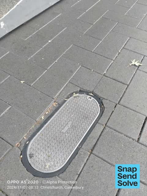
 Pavement - Damaged,
This cover has sunk, is loose and tiles around it inconsistent. Just watched a lady roll her ankle badly on it. Outside shop ‘north face’
 Bus Shelter Issue,
 Pavement - Damaged,
This telecom chamber lid is about one inch dunk below the footpath level. It is a real trip out stubbed toe hazard. Needs to be fixed
 Accessibility,
Sunken telecom cover - an elderly lady trip and injured herself due to this issue. Health and safety priority
 Pavement - General,
Telecom access cover has sunken into the tiles and is causing a trip hazard. Member over the public has already tripped and fallen. Located
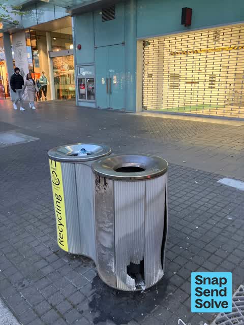
 Rubbish and Bins - General,
Bins damaged outside The North Face on Colombo Street
 Pavement - General,
Missing motorbike parking sign causing trap hazard?
- Graffiti,
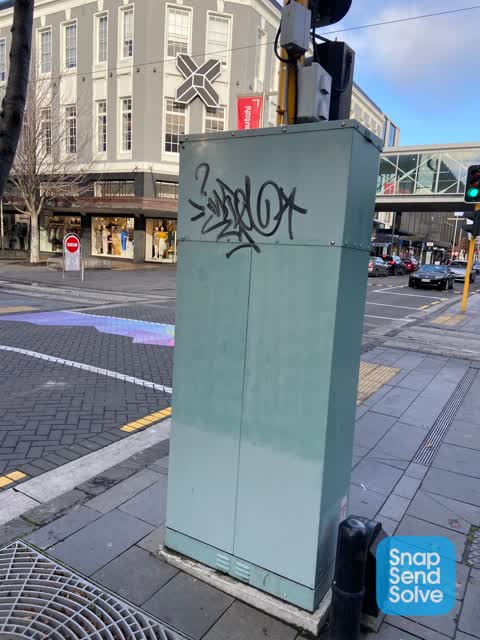
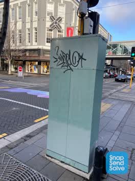 Graffiti,
Black and blue paint tags on QTC traffic controller on the corner of Colombo and Cashel Streets.
Also reported on Colombo Street
- 794 Colombo Street, 159 reports
- 673 Colombo Street, 102 reports
- 781 Colombo Street, 55 reports
- 521 Colombo Street, 46 reports
- 722 Colombo Street, 45 reports
- 569 Colombo Street, 45 reports
- 527 Colombo Street, 41 reports
- 711 Colombo Street, 38 reports
From the air, then
Sourced from Canterbury Maps and partners. LINZ, CC BY 3.0 NZ. Each frame is cut from Environment Canterbury’s historic imagery MapServer for that decade, only where the Footprints layer names a CC BY survey (NZAM-covered spots stay out). RetroLens holds more Crown aerials →
The street’s crash record
NZTA’s record names Colombo Street in 177 crashes that hurt somebody since 2006, 1 person killed, 32 seriously hurt.
The green nearby
- City Mall, 30 m to the edge
- The Stewart Plaza, 34 m to the edge
- High Street Triangles, 66 m to the edge
- Cathedral Square, 157 m to the edge · Botanic
- Godley Statue Reserve, 195 m to the edge · Botanic
Parks within half a kilometre, measured to the boundary, the council’s open data.
The civic shelf nearby
- Triangle, 33 m away · Car park
- Re:start - Lichfield Street, 237 m away · Car park
- Turanga Library, 296 m away · Library · Cathedral Square, Christchurch
- Civic Offices, 419 m away · Council office
- Scales, 473 m away · Car park
Libraries, halls and the rest within half a kilometre, the council’s open data.
On the doorstep
- Global Culture, 21 m away · Clothing
- ANZ Bank, 28 m away · Business
- Macpac, 29 m away · Outdoor gear
- Mia Piaci Shoes & Bags, 30 m away · Business
Businesses within four hundred metres, measured at the pin: OpenStreetMap and the council directories.
The bus nearby
- Hereford St near Colombo St, 110 m away · route 8
- Hereford St near Colombo St, 119 m away · route 8
The closest Metro stops, within four hundred and fifty metres.
The tracks through here
- Walk and bike track through Christchurch Central City, 228 m to the line · walk · bike
- Walk and bike track through Christchurch Central City, 235 m to the line · walk · bike
- Walk and bike track through Christchurch Central City, 235 m to the line · walk · bike
- Walk and bike track through Christchurch Central City, 237 m to the line · walk · bike
- Walk and bike track through Christchurch Central City, 269 m to the line · walk · bike
Tracks whose line passes within half a kilometre, measured to the line itself, the council’s open data.
The named ground
Named water within 500 m of this address, measured to the line or the edge; Named places within 1.5 km of this address; the council’s own structure register, bridges, boardwalks and steps standing nearby, the open map’s record.
The remembered names nearby
- Te Kiheru Wai o Tahu / the Canoe Bailer of Tahu / 2015, 153 m away ·
Te Kiheru Wai o Tahu / The Canoe Bailer of Tahu / 2015 / (MÄori text and English translat
· 2015 - Citizens’ War Memorial / Originally Dedicated on 9 June 1937, 230 m away ·
Citizens’ War Memorial / Originally dedicated on 9 June 1937 / Damaged by the Canterbury E
· 2023 - The Combined Services / [service Crests] / Navy, 234 m away ·
THE COMBINED SERVICES / [service crests] / NAVY / NEW ZEALAND ARMY / AIR FORCE / MERCHANT
· 2023
Inscribed plaques within two hundred and fifty metres, the register’s pins, not surveyed spots. The whole roll is at /plaques.
Renting nearby
new bonds in Christchurch Central City ran about $508 a week, $42 below the city median of $550, the suburb page keeps the rent record →.
What was here, Triangle Reserve and Setting
49 m away · 291F High Street · located to ±18 m · the place’s own record →
On the register. Nothing researched here yet.
What was here, Former Beaths Department Store (components)
65 m away · 201/690 Colombo Street · located to ±21 m · the place’s own record →
On the register. Nothing researched here yet.
What was here, Triangle Reserve and Setting
81 m away · 261F High Street · located to ±18 m · the place’s own record →
On the register. Nothing researched here yet.
What was here, Triangle Reserve and Setting
164 m away · 220F High Street · located to ±17 m · the place’s own record →
On the register. Nothing researched here yet.
What was here, Commercial Building and Setting, Former Chief Post Office
172 m away · 1 Cathedral Square · located to ±33 m · the place’s own record →
On the register. Nothing researched here yet.
The civic layer
This ground votes in Central ward, the Papanui-Innes-Central community board. Ward lines don’t always follow suburb lines; this one is measured at the pin, not the suburb’s centre.
What stood on this ground → · On the map → · From the air, the Crown’s aerials back to 1936; search the address on RetroLens →
Questions, answered briefly
12 council reports on record since June 2022, most often pavement - general (2), pavement - damaged (2), graffiti on a fence, building or structure (2).
Christchurch Central City, Christchurch, on Colombo Street.
The heritage register names 5 places at or beside it, Triangle Reserve and Setting, Former Beaths Department Store (components).
City Mall, 30 m to its edge.