2 Kinsey Terrace
7 council reports since December 2020, 5 carrying a photograph. The most-reported address on Kinsey Terrace.
From the air, then
Sourced from Canterbury Maps and partners. RNZAF, CC BY 3.0 NZ. Each frame is cut from Environment Canterbury’s historic imagery MapServer for that decade, only where the Footprints layer names a CC BY survey (NZAM-covered spots stay out). RetroLens holds more Crown aerials →
The green nearby
- Shag Rock Reserve, 85 m to the edge
- Sumner Beach, 135 m to the edge · Regional · 8 ha
- Sumner Coronation Garden, 168 m to the edge
- Shag Rock, 314 m to the edge · Regional
- Brownlee Reserve, 345 m to the edge · 3 ha · playground, 24 pieces
Parks within half a kilometre, measured to the boundary, the council’s open data. The whole roll is at /parks.
On the doorstep
- Sumner Surf Life Saving Club, 200 m away · Clubs
- Sumner Coronation Garden, 211 m away · Attractions
- Casamassima Italian Fare, 252 m away · Bottle stores
- Big Bear Breakfast Burritos, 400 m away · Fast food
Businesses within four hundred metres, measured at the pin, OpenStreetMap and the council directories.
The bus nearby
- Clifton Tce and Main Rd, 205 m away · route 3
- Main Rd near Marriner St, 268 m away · route 3
The closest Metro stops, within four hundred and fifty metres.
The tracks through here
- Walk and bike track through Clifton, 119 m to the line · walk · bike
Tracks whose line passes within half a kilometre, the council’s open data.
The named ground
Named places within 1.5 km of this address; the council’s own structure register, bridges, boardwalks and steps standing nearby, the open map’s record.
The remembered names nearby
- This Plaque Placed by the Sumner-Redcliffs Historical, 168 m away ·
This plaque placed by the Sumner-Redcliffs Historical Society in memory of Sir Terence McC
· 2009 - These Three Stone Lampstandards Were Built in 1939, 247 m away ·
THESE THREE STONE LAMPSTANDARDS WERE BUILT IN 1939 BY THE SUMNER BOROUGH COUNCIL... RENEWE
· 2009
Inscribed plaques within two hundred and fifty metres, the register’s pins, not surveyed spots. The whole roll is at /plaques.
Renting nearby
new bonds in Clifton ran about $820 a week, $270 above the city median of $550, the suburb page keeps the rent record →.
What gets reported here
Photographed here 5 on record


What’s on record
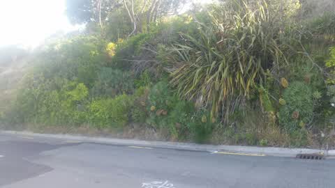
 Overgrown Vegetation, 20 Dec 2025
 Fire risk and untidy ??
 Overgrown Vegetation, 4 Nov 2025
 I advised in July 2025 and nudged in August that a Taupata and succulents were growing on the bend at 2 Kinsey Terrace. This is a section cu
 Fallen Tree, 21 Oct 2025
 2nd hairpin up Clifton Hill branch blown down into road in these strong winds
 Overgrown Vegetation, 17 Oct 2024
 Why do 1/2 the grass?? This happens here slot. It’s not that steep and as easy to weedeat.
- Pit and Equipment - General, 14 Dec 2022
- Overgrown Vegetation, 14 Dec 2022
 Parks, 13 Dec 2020
 Kia ora, I don't know if the Council does pest trapping at all? So this might not be at all useful, but just in case, I just saw a family o
Elsewhere on Kinsey Terrace
- 39 Kinsey Terrace, 5 reports
- 47 Kinsey Terrace, 4 reports
- 46 Kinsey Terrace, 4 reports
- 32 Kinsey Terrace, 4 reports
- 25 Kinsey Terrace, 4 reports
- 15 Kinsey Terrace, 4 reports
- 55 Kinsey Terrace, 3 reports
- 30 Kinsey Terrace, 3 reports
The civic layer
This ground votes in Heathcote ward, the Spreydon-Cashmere-Heathcote community board is its local layer. Ward lines don’t always follow suburb lines; this one is measured at the pin, not the suburb’s centre. The whole roll is at /wards.
Kinsey Terrace, the whole record → · Everything about Clifton → · What stood on this ground → · On the map → · From the air, RetroLens holds the Crown’s aerials back to 1936; search the address there →
Questions, answered briefly
7 council reports on record since December 2020, most often overgrown vegetation (4), pit and equipment - general (1), parks (1).
Clifton, Christchurch, on Kinsey Terrace.
Nothing on the heritage register at this exact spot, the record around this ground →
Shag Rock Reserve, 85 m to its edge.