47 Park Terrace, Corsair Bay
18 reports on record since September 2022 · 15 with photographs. The street’s heaviest record is 72 Park Terrace — 120 reports on file. Indicative rating valuation and school zones, hazards, bin day and what stood here before.
What gets reported here
Photographed here 15 on record



Reported here
 Abandoned Vehicle —
 Older model ute with no wheels, no Wof and expired Rego sitting abandoned in parking area opposite Corsair Bay.
 Graffiti somewhere else —
  Graffiti somewhere else —
  Overgrown Vegetation —
 Tree branches hanging low over footpath obstructing access to walkway.
 Graffiti on a fence, building or structure —
  Graffiti on a fence, building or structure —
 Green cabinet
 Water Leak —
 L2 LAC losing 3lpm. Back fitting going into the ground needs exposing. Submitted by Detection Services
 Graffiti somewhere else —
  Dumped Rubbish —
 Building rubbish dumped from 49 Park terrace (across the road) from when they tidied up the house before putting it on the market
 Graffiti on a fence, building or structure —
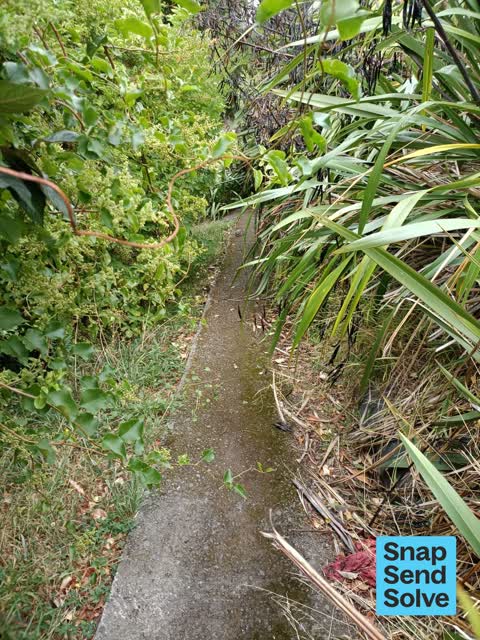
  Overgrown Vegetation —
 Overgrown flex leaves and muelenbeckia obstructing access path down from Park terrace to Corsair Bay
 Graffiti —
 On trees and power boxes
 Graffiti —
 Ignore address photo taken at exit of Corsir Bay. NB 2 lots tree, box.
 Graffiti —
 Sadly someone has seen fit to make their mark on the beautiful macro at Corsair Bay
 Graffiti —
 This beautiful, old and symbolic tree has been tagged by some mindless individual. It must be related to “boy racers” in some way. I have tr
- Street Gutters / Storm Water —
- Pothole —
- Graffiti —
Also reported on Park Terrace
- 72 Park Terrace — 120 reports
- 19 Park Terrace — 21 reports
- 5 Park Terrace — 10 reports
- 44A Park Terrace — 9 reports
- 38 Park Terrace — 9 reports
- 52 Park Terrace — 8 reports
- 34–44 Park Terrace — 8 reports
- 68 Park Terrace — 7 reports
The street’s crash record
NZTA’s record names Park Terrace in 7 crashes that hurt somebody since 2006 — 3 seriously hurt, nobody killed.
The green nearby
- Corsair Bay Reserve — 12 m to the edge · 8 ha
- Park Terrace Reserve — 295 m to the edge · 5 ha
- Cass Bay Walkway — 488 m to the edge
Parks within half a kilometre, measured to the boundary — the council’s open data.
The bus nearby
The closest Metro stops, within four hundred and fifty metres.
The named ground
Named places within 1.5 km of this address; the council’s own structure register — bridges, boardwalks and steps standing nearby — the open map’s record.
The remembered names nearby
- International Year of the Volunteer 2001 — 100 m away ·
INTERNATIONAL YEAR OF THE VOLUNTEER 2001
· 2008
Inscribed plaques within two hundred and fifty metres — the register’s pins, not surveyed spots. The whole roll is at /plaques.
Renting nearby
new bonds in Corsair Bay ran about $600 a week — $50 above the city median of $550 — the suburb page keeps the rent record →.
The civic layer
This ground votes in Banks Peninsula ward — the Banks Peninsula community board. Ward lines don’t always follow suburb lines; this one is measured at the pin, not the suburb’s centre.
What stood on this ground → · On the map → · From the air — the Crown’s aerials back to 1936; search the address on RetroLens →
Questions, answered briefly
18 council reports on record since September 2022 — most often graffiti (5), graffiti somewhere else (3), graffiti on a fence, building or structure (3).
Corsair Bay, Christchurch — on Park Terrace.
Nothing on the heritage register at this exact spot — the record around this ground →
Corsair Bay Reserve — 12 m to its edge, 8 ha.