31 Banks Avenue, Dallington
20 reports on record since April 2018 · 20 with photographs. The street’s heaviest record is 120 Banks Avenue — 55 reports on file. Indicative rating valuation and school zones, hazards, bin day and what stood here before.
What gets reported here
- Dumped Rubbish — 5
- Graffiti on a fence, building or structure — 3
- Graffiti — 3
- Rubbish/Recycling — 2
- General Request — 2
- Water Leak — 1
Photographed here 20 on record


Reported here
 Dumped Rubbish —
 rubbish dumped
 Litter —
  Dumped Rubbish —
 dumped rubbish on vacant lot, couches, microwave etc
 Graffiti on a fence, building or structure —
 graffiti on brown fence
 Overgrown Vegetation —
 overgrown section. needs owner to get it cleared and fence fixed so can't be accessed from st
 Water Leak —
 Leaking toby boxes
 Graffiti on a fence, building or structure —
 Graffiti on fence
 Street Gutters / Storm Water —
 Road cones in Dudley Creek
 Graffiti on a fence, building or structure —
  Dumped Rubbish —
 Dumped by the same people from 2/181 Gayhurst Rd who dumped at 100 Banks Ave. That rubbish is now blowing into the stream because it's still
 Dumped Rubbish —
  Dumped Rubbish —
  Graffiti —
  General Request —
  Graffiti —
 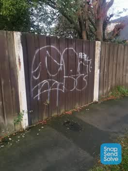 Graffiti —
 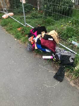 Rubbish/Recycling —
 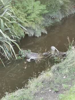 General Request —
 Trolley in Dudley Creek
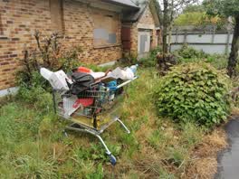 Rubbish/Recycling —
 Also countdown abandoned trolley. This is separate to the one I reported opposite the school.
Roading/Streets —
Branches over the footpath
Also reported on Banks Avenue
- 120 Banks Avenue — 55 reports
- 96 Banks Avenue — 47 reports
- 100 Banks Avenue — 47 reports
- 104 Banks Avenue — 46 reports
- 87 Banks Avenue — 37 reports
- 77 Banks Avenue — 36 reports
- 81 Banks Avenue — 23 reports
- 79 Banks Avenue — 22 reports
The street’s crash record
NZTA’s record names Banks Avenue in 5 crashes that hurt somebody since 2006 — 0 seriously hurt, nobody killed.
The green nearby
- Richmond Park — 144 m to the edge · Sports ground · 4 ha
- Dudley Creek Riverbank — 289 m to the edge
- Avon Riverbank True Right — 396 m to the edge · 11 ha
Parks within half a kilometre, measured to the boundary — the council’s open data.
On the doorstep
- Richmond Rhinos Cricket Club — 308 m away · Clubs
- Shirley Tennis Club — 308 m away · Clubs
- CityFitness — 399 m away · Gyms & fitness
- Snap Fitness — 400 m away · Gyms & fitness
Businesses within four hundred metres, measured at the pin — OpenStreetMap and the council directories.
The bus nearby
- New Brighton Rd near Netherby Ln — 347 m away · route 7, route 44, route 110
- North Parade — 380 m away · route 60, the Orbiter (anticlockwise)
The closest Metro stops, within four hundred and fifty metres.
The tracks through here
- Walk and bike track through Dallington — 267 m to the line · walk · bike
- Walk and bike track through Dallington — 292 m to the line · walk · bike
- Walk and bike track through Dallington — 339 m to the line · walk · bike
- Walk and bike track through Dallington — 351 m to the line · walk · bike
- Walk and bike track through Dallington — 356 m to the line · walk · bike
Tracks whose line passes within half a kilometre, measured to the line itself — the council’s open data.
The named ground
Named water within 500 m of this address, measured to the line or the edge; the council’s own structure register — bridges, boardwalks and steps standing nearby — the open map’s record.
Renting nearby
new bonds in Dallington ran about $520 a week — $30 below the city median of $550 — the suburb page keeps the rent record →.
The civic layer
This ground votes in Burwood ward — the Coastal-Burwood-Linwood community board. Ward lines don’t always follow suburb lines; this one is measured at the pin, not the suburb’s centre.
What stood on this ground → · On the map → · From the air — the Crown’s aerials back to 1936; search the address on RetroLens →
Questions, answered briefly
20 council reports on record since April 2018 — most often dumped rubbish (5), graffiti on a fence, building or structure (3), graffiti (3).
Dallington, Christchurch — on Banks Avenue.
Nothing on the heritage register at this exact spot — the record around this ground →
Richmond Park — 144 m to its edge, 4 ha.