36 Westlake Drive, Halswell
22 reports on record since March 2020 · 17 with photographs. The street’s heaviest record is 50 Westlake Drive — 118 reports on file. Indicative rating valuation and school zones, hazards, bin day and what stood here before.
What gets reported here
- Pavement - Damaged — 11
- Parks — 5
- Graffiti — 3
- Trees - General — 1
- Overgrown Vegetation — 1
- Fallen Tree — 1
Photographed here 17 on record


Reported here
 Pavement - Damaged —
 Broken path
 Pavement - Damaged —
 Walking path has major cracks, on left side of the large lake heading to the jetty area. Could cause injury to pedestrians and cyclists etc
 Pavement - Damaged —
 Westlake Park footpath. Been like it since earthquake. Certainly worse than other footpaths in area getting resealed.
 Fallen Tree —
 Two large branches have snapped off a tree and are now completely blocking the footpath. One branch is hanging precariously
 Pavement - Damaged —
 Just an update to my post a few days ago. Our kids are diligently biking and scootering to school as part of the “walk or wheel to school we
 Pavement - Damaged —
 Large cracks in the path. My daughter hit one of the cracks on her scooter and went over the handlebars and landed hard. Luckily no broken b
 Pavement - Damaged —
 Massive cracks in path, dangerous with kids on scooters or bikes. Crack is wide enough for wheel to fit
 Pavement - Damaged —
 There are 5 trees growing on the edge of a new section of footpath. They need to be removed before the footpath is damaged
 Pavement - Damaged —
 The hole in the middle of the footpath is now so large - 7cm (photo 1) that any child’s scooter wheel that hits this will result in injury t
 Pavement - Damaged —
 These large cracks are a serious danger to the many young children riding their scooters along this stretch of footpath to and from school a
 Pavement - Damaged —
 Cracks in pavement getting worse
 Trees - General —
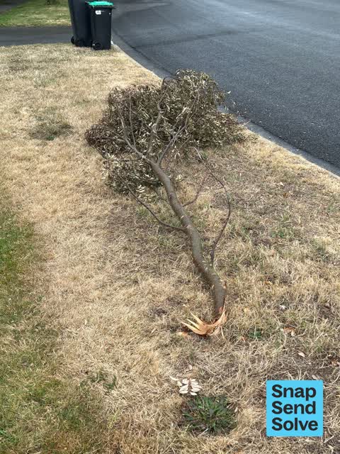
 Some vandals ripped this branch off the tree in the background and dumped it on the verge outside the reserve
- Pavement - Damaged —
- Graffiti —
- Graffiti —
- Graffiti —
- Overgrown Vegetation —
 Parks —
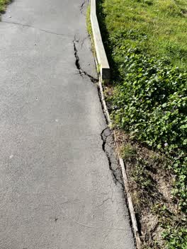
 Footpath cracks starting to widen in Westlake Reserve
 Parks —
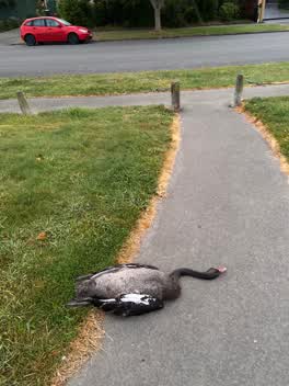
 Opposite 35 Westlake Drive just inside the park is a dead black swan that needs to be removed
 Parks —
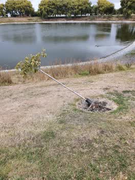
 broken tree
 Parks —
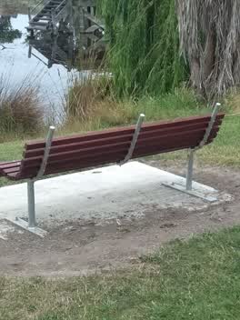
 this has been left as an health and safety hazard without being flagged. prongs sticking up are dangerous
Parks —
westlake reserve please arrange removal for mowing
Also reported on Westlake Drive
- 50 Westlake Drive — 118 reports
- 52 Westlake Drive — 14 reports
- 38 Westlake Drive — 10 reports
- 39 Westlake Drive — 9 reports
- 36E Westlake Drive — 7 reports
- 34 Westlake Drive — 7 reports
- 58 Westlake Drive — 6 reports
- 25A Westlake Drive — 6 reports
The street’s crash record
NZTA’s record names Westlake Drive in 3 crashes that hurt somebody since 2006 — 0 seriously hurt, nobody killed.
The green nearby
- Westlake Reserve — you are in it · Sports ground · 11 ha
- Campion Reserve — 272 m to the edge
- Vanderbilt Reserve — 349 m to the edge
- Lancewood Reserve — 472 m to the edge
- Stallion Reserve — 492 m to the edge
Parks within half a kilometre, measured to the boundary — the council’s open data.
The bus nearby
The closest Metro stops, within four hundred and fifty metres.
The tracks through here
- Walk and bike track through Halswell — 2 m to the line · walk · bike
- Walk and bike track through Halswell — 78 m to the line · walk · bike
- Walk and bike track through Halswell — 100 m to the line · walk · bike
- Walk and bike track through Halswell — 131 m to the line · walk · bike
- Walk and bike track through Halswell — 147 m to the line · walk · bike
Tracks whose line passes within half a kilometre, measured to the line itself — the council’s open data.
The named ground
Named water within 500 m of this address, measured to the line or the edge; Named places within 1.5 km of this address; the council’s own structure register — bridges, boardwalks and steps standing nearby — the open map’s record.
The remembered names nearby
- Adopt a Park the Rotary Clubs of Garden City Christchurch — 62 m away ·
Adopt a Park The Rotary Clubs of Garden City Christchurch & Sakai South East Osaka have ad
· 2008 - Built As a Joint Project Together With the Rotary Club — 125 m away ·
BUILT AS A JOINT PROJECT TOGETHER WITH THE ROTARY CLUB OF SAKAI-SOUTH EAST, JAPAN AND ROTA
· 2008 - In Memory of AJ Tragically Taken on 29-12-2004 Aged — 149 m away ·
IN MEMORY OF AJ TRAGICALLY TAKEN ON 29-12-2004 AGED 18 YEARS LOVED BY HIS FAMILY AND FRIEN
· 2008
Inscribed plaques within two hundred and fifty metres — the register’s pins, not surveyed spots. The whole roll is at /plaques.
Renting nearby
new bonds in Halswell ran about $697 a week — $147 above the city median of $550 — the suburb page keeps the rent record →.
The civic layer
This ground votes in Halswell ward — the Halswell-Hornby-Riccarton community board. Ward lines don’t always follow suburb lines; this one is measured at the pin, not the suburb’s centre.
What stood on this ground → · On the map → · From the air — the Crown’s aerials back to 1936; search the address on RetroLens →
Questions, answered briefly
22 council reports on record since March 2020 — most often pavement - damaged (11), parks (5), graffiti (3).
Halswell, Christchurch — on Westlake Drive.
Nothing on the heritage register at this exact spot — the record around this ground →
Westlake Reserve — the address is inside it, 11 ha.