443 Marshs Road, Halswell
21 reports on record since August 2017 · 17 with photographs. The most-reported address on Marshs Road. Indicative rating valuation and school zones, hazards, bin day and what stood here before.
What gets reported here
Photographed here 17 on record


Reported here
 Dumped Rubbish,
 Two piles of rubbish dumped
 Dumped Rubbish,
 Dumped rubbish on Marshs Road
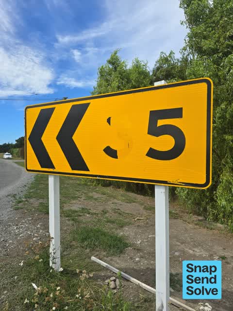
 Damaged Street Sign,
  Poles and Signage - General,
 Graffiti on power pole corner of marsh’s road
 Dumped Rubbish,
 Tyres & rubber dumped opposite our driveway overnight last night.
 Damaged Road,
 Edge breaking away with trucks driving wide on road.
 Dumped Rubbish,
 Car body part a d bag of underlay
 Rubbish and Bins - General,
 Green wheelie bin hinge broken. Bin needs replacing.
 Dumped Rubbish,
  Dumped Rubbish,
 Dump rubbish
 Road Signage,
 Number been ripped off needs replacing
- Damaged Road,
- Pothole,
- Pothole,
- Street Gutters / Storm Water,
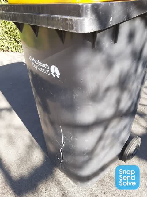
 Rubbish and Bins - General,
 Recycle Yellow Bin cracked and requires to be replaced.
 Dumped Rubbish,
  Dumped Rubbish,
 Cross the road from 443 Marshs Road under power pole.
Dumped Rubbish,
almost opposite 448 Marshs Road Halswell
Rubbish/Recycling,
One pig carcass plus numerous domestic rubbish damped in drain between 443 and 469 Marshs Road Halswell. The pig carcass needs to be removed
Roading/Streets,
Dangerous deep potholes on 90 degree corner. Vehicles are swerving over white line to avoid potholes, on this blind corner.
Also reported on Marshs Road
- 466 Marshs Road, 14 reports
- 566 Marshs Road, 7 reports
- 427 Marshs Road, 7 reports
- 350A Marshs Road, 7 reports
- 487 Marshs Road, 6 reports
- 403 Marshs Road, 4 reports
- 446 Marshs Road, 3 reports
- 435 Marshs Road, 3 reports
From the air, then
Sourced from Canterbury Maps and partners. LINZ, CC BY 3.0 NZ. Each frame is cut from Environment Canterbury’s historic imagery MapServer for that decade, only where the Footprints layer names a CC BY survey (NZAM-covered spots stay out). RetroLens holds more Crown aerials →
The street’s crash record
NZTA’s record names Marshs Road in 24 crashes that hurt somebody since 2006, 1 person killed, 4 seriously hurt.
The green nearby
- Knights Waterway Reserve, 409 m to the edge · 5 ha
Parks within half a kilometre, measured to the boundary, the council’s open data.
The named ground
Named water within 500 m of this address, measured to the line or the edge, the open map’s record.
Renting nearby
new bonds in Halswell ran about $697 a week, $147 above the city median of $550, the suburb page keeps the rent record →.
The civic layer
This ground votes in Halswell ward, the Halswell-Hornby-Riccarton community board. Ward lines don’t always follow suburb lines; this one is measured at the pin, not the suburb’s centre.
What stood on this ground → · On the map → · From the air, the Crown’s aerials back to 1936; search the address on RetroLens →
Questions, answered briefly
21 council reports on record since August 2017, most often dumped rubbish (9), rubbish and bins - general (2), pothole (2).
Halswell, Christchurch, on Marshs Road.
Nothing on the heritage register at this exact spot, the record around this ground →
Knights Waterway Reserve, 409 m to its edge, 5 ha.