155 Clarendon Terrace, Hillsborough
45 reports on record since April 2016 · 41 with photographs. The street’s heaviest record is 153 Clarendon Terrace — 92 reports on file. Indicative rating valuation and school zones, hazards, bin day and what stood here before.
What gets reported here
Photographed here 41 on record


Reported here
 Dumped Rubbish —
 Dumped rubbish on Clarendon Terrace near railway ocerbridge
- Dumped Rubbish —
dumped Tyre rubbish bag metal cardboard boxes rubber
 Dumped Rubbish —
 Dumped care parts
 Dumped Rubbish —
  Dumped Rubbish —
  Abandoned Vehicle —
 abandoned car
 Abandoned Vehicle —
 Kia ora, Thi car has been dumped. It’s been there 2-3 wks now. I drive past it twice a day, no change. Nga mihi, Nicola
 Abandoned Vehicle —
 Abandoned car. Been here for a few days now.
 Dumped Rubbish —
 Rubbish dumped under overhead bridge
 Dumped Rubbish —
  Dumped Rubbish —
 dumped rubbish
 Dumped Rubbish —
 Old mattress on river side near over bridge
 Water Leak —
 Water leak under the rail/road bridge near Opawa Road on Clarendon Terrace
 Dumped Rubbish —
 Lots of dumped rubbish by side of highway
 Water Leak —
 Major water leak under Clarendon Terrace Rail/Road bridge
 Water General —
 Since they worked on the water infrastructure on our street and replaced the meter box the water to our section has stopped working.
 Dumped Rubbish —
 Dumped cables with copper wiring removed and two sacks of rubbish
 Dumped Rubbish —
 Duvet, pillow & other rubbish in trees - could be a rough sleeper? Rubbish is close to the river. Please collect asap ,
 Dumped Rubbish —
  Dumped Rubbish —
  Damaged Street Sign —
 30 signed removed and dumped by the road
 Graffiti on a road, footpath or bridge —
 Offensuve graffiti
 Rubbish and Bins - General —
 Bins thrown into River
 Dumped Rubbish —
 Two bins, one looks to be rubbish and the other green, are in the Heathcote River, stuck on the bank. Just up from the brougham river bridge
 Dumped Rubbish —
 Rubbish still there as per my snap about a week or so ago. Except now whoever mows / line trims the grass has spread it round. Just what the
 Dumped Rubbish —
  Graffiti on a road, footpath or bridge —
  Dumped Rubbish —
 Dumped rubbish by rail bridge Clarendon Terrace
 Overgrown Vegetation —
 The footpath is getting taken over by weeds. Plus it attracts rubbish dumping.
 Water Leak —
 Fire hydrant leak
 Water Leak —
 Water seeping from hydrant in road. Some possible slumping
 Water Leak —
 - Dumped Rubbish —
- Abandoned Vehicle —
- Pavement - Damaged —
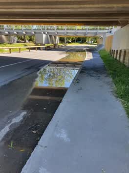 Flooding —
 Seems to have drainage problems. Hasnt rained in days and has been very hot. Cars will drive on front side of that road to avoid water.
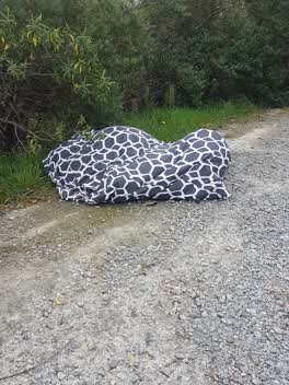 Dumped Rubbish —
 Roading/Streets —
When road and kerb n channel were repaired holes were put in berm for pipes to drain water from area. These holes have never been filled in.
Water Supply —
Previously repaired fire hydrant leaking an ac repair slumping
Graffiti —
Brougham over pass, three places
Wastewater/Stormwater —
Please clear drains check one way flaps and sandbag this low area under the bridge in preparation for forcast flooding.
Rubbish/Recycling —
Clothing or some form of fabric, dumped on the side of the road near the river
Roading/Streets —
Road hump with no signage and poor paint markings, both sides of the river. Pothole under the rail bridge, large and deep.
Graffiti —
Both sides of sign
Rubbish/Recycling —
Opposite The Hollies
Also reported on Clarendon Terrace
- 153 Clarendon Terrace — 92 reports
- 154 Clarendon Terrace — 2 reports
- 149-151 Clarendon Terrace — 1 report
- 147 Clarendon Terrace — 1 report
The street’s crash record
NZTA’s record names Clarendon Terrace in 1 crash that hurt somebody since 2006 — 0 seriously hurt, nobody killed.
The green nearby
- Heathcote Riverbank Reserve — 127 m to the edge
- Monro Playground — 227 m to the edge
- Hansen Park — 367 m to the edge · Sports ground · 12 ha
- Risingholme Park — 397 m to the edge · Botanic · 2 ha
- Radley Playground — 452 m to the edge
Parks within half a kilometre, measured to the boundary — the council’s open data.
On the doorstep
- Opawa Discounter — 130 m away · Dairies & convenience
- J Mart — 162 m away · Dairies & convenience
- Gelato Lab — 164 m away · Ice cream
- Noble Merchant — 173 m away · Delis
Businesses within four hundred metres, measured at the pin — OpenStreetMap and the council directories.
The bus nearby
The closest Metro stops, within four hundred and fifty metres.
The tracks through here
- Walk and bike track through Hillsborough — 41 m to the line · walk · bike
- Walk and bike track through Hillsborough — 65 m to the line · walk · bike
- Walk and bike track through Hillsborough — 76 m to the line · walk · bike
- Walk and bike track through Hillsborough — 95 m to the line · walk · bike
- Walk and bike track through Hillsborough — 175 m to the line · walk · bike
Tracks whose line passes within half a kilometre, measured to the line itself — the council’s open data.
The named ground
Named water within 500 m of this address, measured to the line or the edge; the council’s own structure register — bridges, boardwalks and steps standing nearby — the open map’s record.
Renting nearby
new bonds in Hillsborough ran about $445 a week — $105 below the city median of $550 — the suburb page keeps the rent record →.
What was here — Dwelling and Setting, The Hollies
77 m away · 188 Richardson Terrace · located to ±22 m · the place’s own record →
On the register. Nothing researched here yet.
The civic layer
This ground votes in Heathcote ward — the Spreydon-Cashmere-Heathcote community board. Ward lines don’t always follow suburb lines; this one is measured at the pin, not the suburb’s centre.
What stood on this ground → · On the map → · From the air — the Crown’s aerials back to 1936; search the address on RetroLens →
Questions, answered briefly
45 council reports on record since April 2016 — most often dumped rubbish (20), water leak (5), abandoned vehicle (4).
Hillsborough, Christchurch — on Clarendon Terrace.
The heritage register names a place at or beside it — Dwelling and Setting, The Hollies.
Heathcote Riverbank Reserve — 127 m to its edge.