21 Lychgate Close, Linwood
15 reports on record since January 2024 · 15 with photographs. The street’s heaviest record is 20 Lychgate Close — 25 reports on file. Indicative rating valuation and school zones, hazards, bin day and what stood here before.
What gets reported here
Photographed here 15 on record

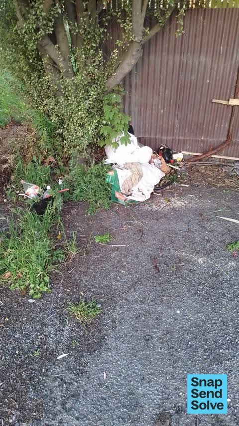


Reported here
 Damaged Street Light —
 panel taken off lamp post leaving electrical connections exposed
 Dumped Rubbish —
 rubbish
 Dumped Rubbish —
 lychate close
 Rubbish and Bins - General —
  Dumped Rubbish —
 lychee close
 Dumped Rubbish —
 lychgate close council area near church
 Dumped Rubbish —
 lychgate place
 Dumped Rubbish —
 lychgate place avonside
 Dumped Rubbish —
 Council land near church Lychgate lane Avonside people living there
 Dumped Rubbish —
 Previous carpark residents have left structures and pallets piled up against fence. Intruders are using these to jump over the fence and int
 Accessibility —
 Rough sleeper has been there for a long time. I think in red zone
 Dumped Rubbish —
  Dumped Rubbish —
  Dumped Rubbish —
  Sewer - Leak / Blockage —
Also reported on Lychgate Close
- 20 Lychgate Close — 25 reports
- 20A Lychgate Close — 1 report
The street’s crash record
NZTA’s record names Lychgate Close in 2 crashes that hurt somebody since 2006 — 0 seriously hurt, nobody killed.
The green nearby
- Beverley Park — 153 m to the edge · 3 ha
- Avon Riverbank True Right — 449 m to the edge · 11 ha
- Alexandra Park — 480 m to the edge
Parks within half a kilometre, measured to the boundary — the council’s open data.
On the doorstep
- Woodham Road Pharmacy — 248 m away · Pharmacies
- Woodham Road Healthcare — 251 m away · Doctors & clinics
- Woodham Road Medical Centre — 254 m away · Business
- Richmond Vege Mart — 336 m away · Fruit & veg
Businesses within four hundred metres, measured at the pin — OpenStreetMap and the council directories.
The bus nearby
- Stanmore Rd near Lychgate Cl — 137 m away · route 60
- Stanmore Rd near Lychgate Cl — 152 m away · route 60
The closest Metro stops, within four hundred and fifty metres.
The tracks through here
- Walk and bike track through Linwood — 63 m to the line · walk · bike
- Walk and bike track through Linwood — 143 m to the line · walk · bike
- Walk and bike track through Linwood — 155 m to the line · walk · bike
- Walk and bike track through Linwood — 229 m to the line · walk · bike
- Walk and bike track through Linwood — 270 m to the line · walk · bike
Tracks whose line passes within half a kilometre, measured to the line itself — the council’s open data.
The named ground
Named water within 500 m of this address, measured to the line or the edge; the council’s own structure register — bridges, boardwalks and steps standing nearby — the open map’s record.
Renting nearby
new bonds in Linwood ran about $478 a week — $72 below the city median of $550 — the suburb page keeps the rent record →.
What was here — Holy Trinity Avonside Lychgate and Setting
49 m away · 168 Stanmore Road · located to ±4 m · the place’s own record →
On the register. Nothing researched here yet.
What was here — Holy Trinity Avonside Graveyard and Setting
60 m away · 168 Stanmore Road · located to ±55 m · the place’s own record →
On the register. Nothing researched here yet.
The civic layer
This ground votes in Central ward — the Papanui-Innes-Central community board. Ward lines don’t always follow suburb lines; this one is measured at the pin, not the suburb’s centre.
What stood on this ground → · On the map → · From the air — the Crown’s aerials back to 1936; search the address on RetroLens →
Questions, answered briefly
15 council reports on record since January 2024 — most often dumped rubbish (11), sewer - leak / blockage (1), rubbish and bins - general (1).
Linwood, Christchurch — on Lychgate Close.
The heritage register names 2 places at or beside it — Holy Trinity Avonside Lychgate and Setting, Holy Trinity Avonside Graveyard and Setting.
Beverley Park — 153 m to its edge, 3 ha.