447 Cashel Street, Linwood
11 reports on record since May 2023 · 10 with photographs. The street’s heaviest record is 573 Cashel Street — 70 reports on file. Indicative rating valuation and school zones, hazards, bin day and what stood here before.
What gets reported here
Photographed here 10 on record




Reported here
 Dumped Rubbish —
  Dumped Rubbish —
  Dumped Rubbish —
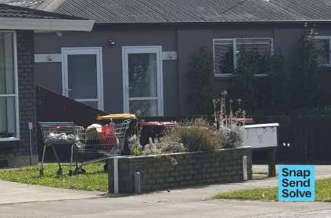
 Dumped rubbish and trolleys
 Water Leak —
 Water has been running out for two weeks
 Water Leak —
 Water has been leaking from the ground at the front of unit 2 for a week at least. Appears to be in the area of the main water connection
 Vandalism - General —
 Bkack paint on wooden sign
 Graffiti on a fence, building or structure —
 Graffiti on porous concrete
 Graffiti on a cabinet, pole or railway asset —
 Broken white plastic conduit cover on Chorus wooden pole 024390 by 443 Cashel Street.
 Dumped Rubbish —
 Chair
 Dumped Rubbish —
 Dumped washing machine
- Dumped Rubbish —
Also reported on Cashel Street
- 573 Cashel Street — 70 reports
- 497 Cashel Street — 44 reports
- 435 Cashel Street — 36 reports
- 393 Cashel Street — 34 reports
- 528 Cashel Street — 27 reports
- 442 Cashel Street — 27 reports
- 446 Cashel Street — 25 reports
- 529 Cashel Street — 24 reports
The street’s crash record
NZTA’s record names Cashel Street in 23 crashes that hurt somebody since 2006 — 1 person killed, 1 seriously hurt.
The green nearby
- Doris Lusk Corner — 173 m to the edge
- Essex Reserve — 245 m to the edge
- Welcome Rest — 246 m to the edge
- Hereford Playground — 278 m to the edge
- Raglan Reserve — 324 m to the edge
Parks within half a kilometre, measured to the boundary — the council’s open data.
On the doorstep
- Cashel Court Motel — 43 m away · Motels
- AquaGym Swim Centre — 90 m away · Sports centres
- Re Sinclair — 116 m away · Car repair
- Expandatrack — 127 m away · Curtain
Businesses within four hundred metres, measured at the pin — OpenStreetMap and the council directories.
The bus nearby
- Stanmore Rd near Worcester St — 187 m away · route 60
- Tuam St near Nursery Rd — 281 m away · route 80
The closest Metro stops, within four hundred and fifty metres.
The tracks through here
- Walk and bike track through Linwood — 66 m to the line · walk · bike
- Walk and bike track through Linwood — 345 m to the line · walk · bike
- Walk and bike track through Linwood — 348 m to the line · walk · bike
- Walk and bike track through Linwood — 382 m to the line · walk · bike
- Walk and bike track through Linwood — 429 m to the line · walk · bike
Tracks whose line passes within half a kilometre, measured to the line itself — the council’s open data.
The named ground
the council’s own structure register — bridges, boardwalks and steps standing nearby — the open map’s record.
The remembered names nearby
- Doris Lusk Corner plaque — 193 m away · 2024
- Plaque no. 311001 — 250 m away · 2024
Inscribed plaques within two hundred and fifty metres — the register’s pins, not surveyed spots. The whole roll is at /plaques.
Renting nearby
new bonds in Linwood ran about $478 a week — $72 below the city median of $550 — the suburb page keeps the rent record →.
What was here — Former Linwood Town Board Offices and Setting
213 m away · 388 Worcester Street · located to ±14 m · the place’s own record →
On the register. Nothing researched here yet.
The civic layer
This ground votes in Central ward — the Papanui-Innes-Central community board. Ward lines don’t always follow suburb lines; this one is measured at the pin, not the suburb’s centre.
What stood on this ground → · On the map → · From the air — the Crown’s aerials back to 1936; search the address on RetroLens →
Questions, answered briefly
11 council reports on record since May 2023 — most often dumped rubbish (6), water leak (2), vandalism - general (1).
Linwood, Christchurch — on Cashel Street.
The heritage register names a place at or beside it — Former Linwood Town Board Offices and Setting.
Doris Lusk Corner — 173 m to its edge.