64 Brittan Street
1 council report since May 2026, 1 carrying a photograph. The street’s heaviest record is 72 Brittan Street, 7 reports on file.
On the register here
- MED Substation, 70E Linwood Avenue (136m)
The green nearby
- Beverley Park, 440 m to the edge · 3 ha · playground, 41 pieces
Parks within half a kilometre, measured to the boundary, the council’s open data. The whole roll is at /parks.
On the doorstep
- Woodham Road Healthcare, 162 m away · Doctors & clinics
- Woodham Road Pharmacy, 170 m away · Pharmacies
- Woodham Road Medical Centre, 178 m away · Business
Businesses within four hundred metres, measured at the pin, OpenStreetMap and the council directories.
The bus nearby
- Woodham Rd near Avonside Dr, 157 m away · the Orbiter (clockwise)
- Woodham Rd near Linwood Ave, 164 m away · the Orbiter (anticlockwise)
The closest Metro stops, within four hundred and fifty metres.
The tracks through here
- Walk and bike track through Linwood, 8 m to the line · walk · bike
- Walk and bike track through Linwood, 137 m to the line · walk · bike
- Walk and bike track through Linwood, 141 m to the line · walk · bike
- Walk and bike track through Linwood, 186 m to the line · walk · bike
- Walk and bike track through Linwood, 231 m to the line · walk · bike
Tracks whose line passes within half a kilometre, the council’s open data.
The named ground
Named water within 500 m of this address, measured to the line or the edge; the council’s own structure register, bridges, boardwalks and steps standing nearby, the open map’s record.
Renting nearby
new bonds in Linwood ran about $478 a week, $72 below the city median of $550, the suburb page keeps the rent record →.
What gets reported here
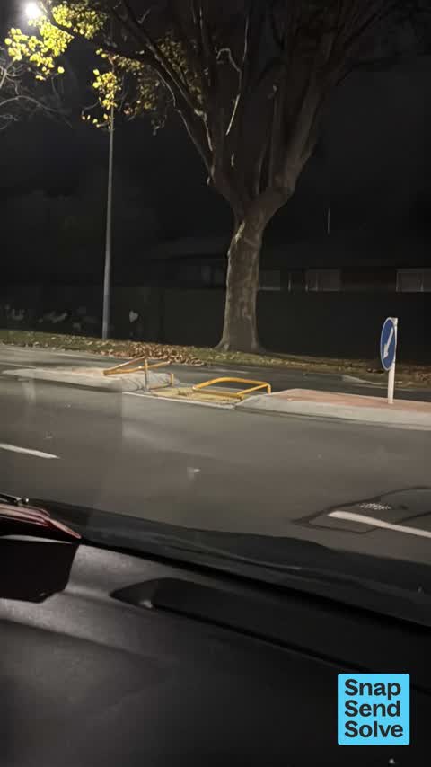
Photographed here 1 on record
What’s on record
 Accessibility, 18 May 2026
Barry is damaged and destroyed will need replacing, blocking pedestrian crossing
Elsewhere on Brittan Street
- 72 Brittan Street, 7 reports
- 6 Brittan Street, 7 reports
- 36 Brittan Street, 7 reports
- 2 Brittan Street, 7 reports
- 5 Brittan Street, 5 reports
- 32 Brittan Street, 5 reports
- 65 Brittan Street, 4 reports
- 56 Brittan Street, 4 reports
The street’s crash record
NZTA’s record names Brittan Street in 4 crashes that hurt somebody since 2006, 1 seriously hurt, nobody killed.
The civic layer
This ground votes in Linwood ward, the Coastal-Burwood-Linwood community board is its local layer. Ward lines don’t always follow suburb lines; this one is measured at the pin, not the suburb’s centre. The whole roll is at /wards.
Brittan Street, the whole record → · Everything about Linwood → · What stood on this ground → · On the map → · Street View → · From the air, RetroLens holds the Crown’s aerials back to 1936; search the address there →
Questions, answered briefly
1 council report on record since May 2026, most often accessibility (1).
Linwood, Christchurch, on Brittan Street.
The heritage register names a place at or beside it, MED Substation.
Beverley Park, 440 m to its edge, 3 ha.