67 Wrights Road, Middleton
26 reports on record since November 2019 · 16 with photographs. The most-reported address on Wrights Road. Indicative rating valuation and school zones, hazards, bin day and what stood here before.
What gets reported here
Photographed here 16 on record




Reported here
 Street Gutters / Storm Water —
 Gutter along cycleway between Wrights Rd and Halls Place needs cleaning. This includes the stormwater drain.
 Graffiti on a fence, building or structure —
 Graffitti along cycleway off Validation Place
 Graffiti on a fence, building or structure —
  General Request —
 Metal ladder like frame leaning against wire strand.
 Graffiti on a fence, building or structure —
  Graffiti on a fence, building or structure —
 Graffiti
 Pavement - Damaged —
 Concrete fence post broken hanging over pathway/cycle way. Hazard for cyclists
 Graffiti on a fence, building or structure —
 Graffiti on fence
- Litter —
There are some small pieces of what looks like finey cement that may contain asbestos on the cycleway here
 Vandalism - General —
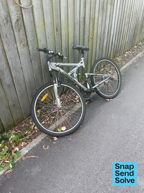
 Abandoned bike and traffic cones
 Graffiti —
 On fencing
 Road Blockage —
 The cycle path is being blocked by the fence that has fallen over. I would have stopped to fix it myself but I was late so only had time to
 Pit and Equipment - General —
 Fence on this pathway is badly damaged and hanging across pavement.
- Graffiti —
- Graffiti —
- Graffiti —
- Fallen Tree —
- Accessibility —
- Graffiti —
- Overgrown Vegetation —
- Graffiti —
- Graffiti —
 Facility - General Request —
 Fence is damaged
 Graffiti —
 Graffiti —
Graffiti —
Also reported on Wrights Road
- 130 Wrights Road — 5 reports
- 71 Wrights Road — 4 reports
- 69 Wrights Road — 4 reports
- 131 Wrights Road — 2 reports
- 65 Wrights Road — 1 report
- 132 Wrights Road — 1 report
The street’s crash record
NZTA’s record names Wrights Road in 3 crashes that hurt somebody since 2006 — 0 seriously hurt, nobody killed.
The green nearby
- Marylands Reserve — 83 m to the edge · Sports ground · 6 ha
- Torrens Reserve — 96 m to the edge
- Linden Grove — 234 m to the edge
- Pavilion Park — 398 m to the edge
- Cardigan Bay Reserve — 478 m to the edge
Parks within half a kilometre, measured to the boundary — the council’s open data.
On the doorstep
- schieder electrical — 100 m away · Electronics
- The Event Collective — 119 m away · Caterers
- CJ's Takeaways — 277 m away · Fast food
- Coastal Espresso — 277 m away · Cafés
Businesses within four hundred metres, measured at the pin — OpenStreetMap and the council directories.
The bus nearby
- Birmingham Dr near Halls Pl — 282 m away · route 140
- Birmingham Dr near Halls Pl — 384 m away · route 140
The closest Metro stops, within four hundred and fifty metres.
The tracks through here
- Walk and bike track through Middleton — 16 m to the line · walk · bike
- Walk and bike track through Middleton — 258 m to the line · walk · bike
Tracks whose line passes within half a kilometre, measured to the line itself — the council’s open data.
The civic layer
This ground votes in Spreydon ward — the Spreydon-Cashmere-Heathcote community board. Ward lines don’t always follow suburb lines; this one is measured at the pin, not the suburb’s centre.
What stood on this ground → · On the map → · From the air — the Crown’s aerials back to 1936; search the address on RetroLens →
Questions, answered briefly
26 council reports on record since November 2019 — most often graffiti (10), graffiti on a fence, building or structure (5), vandalism - general (1).
Middleton, Christchurch — on Wrights Road.
Nothing on the heritage register at this exact spot — the record around this ground →
Marylands Reserve — 83 m to its edge, 6 ha.