3 Rangatira Terrace, Mount Pleasant
11 reports on record since April 2022 · 9 with photographs. The most-reported address on Rangatira Terrace. Indicative rating valuation and school zones, hazards, bin day and what stood here before.
What gets reported here
Photographed here 9 on record


Reported here
 Trees - General —
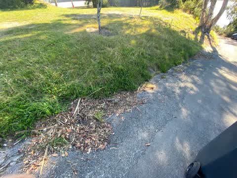
 Hi. Massive self seeded gum tree adjoining our boundary drops branches on the road and blocks drains constantly with foliage. Getting bigger
 Fallen Tree —
 Hi. An update to my last snap 6159148. Another branch lodged in the tree where we park and walk next to our garage. Please can we have someo
 Pavement - General —
 Blocked drains Hi. Grass has been trimmed but drains completely blocked by debris. This has caused road damage, small sink holes in the p
 Overgrown Vegetation —
 Hi 4th try since November 2024. Can someone please call me regarding this or help Richard 0212202812
 Pavement - Damaged —
 Large hole in footpath, big hazard for runners and cyclists coming down the hill fast
- Overgrown Vegetation —
Overgrown vegetation has been cut by a group of locals. Can the ccc please pick up the vegetation. It is piled neatly on Rangatira Tce. Tha
 Pavement - Damaged —
 New sinkhole plus one lower down
 Trees - General —
 Huge self seed gum tree growing on the side of a roadside bank over (and around) power lines. - Shallow roots on side of a bank - Fire risk
 Street Gutters / Storm Water —
 Hole has formed in gutter outside 3 Rangatira Tce and water running under road out to a bank on Mt Pleasant Road. Caused by water leak at 17
- Overgrown Vegetation —
 Roading/Streets —
 Blocked drain plus dead trees and unmaintained reserve area. Also trees and hedge impeding larger/ high vehicles access (bike on top of car/
Also reported on Rangatira Terrace
- 7 Rangatira Terrace — 8 reports
- 15 Rangatira Terrace — 4 reports
- 61 Rangatira Terrace — 3 reports
- 17 Rangatira Terrace — 2 reports
- 9–17 Rangatira Terrace — 1 report
- 3–7 Rangatira Terrace — 1 report
The street’s crash record
NZTA’s record names Rangatira Terrace in 4 crashes that hurt somebody since 2006 — 2 seriously hurt, nobody killed.
The green nearby
- King Park — you are in it · 2 ha
- Mccormacks Bay — 111 m to the edge · Sports ground · 22 ha
- The Brae — 127 m to the edge
- Scott Park Ferrymead — 386 m to the edge · 2 ha
- Te Awakura Reserve — 453 m to the edge
Parks within half a kilometre, measured to the boundary — the council’s open data.
On the doorstep
- Mt Pleasant Farmers Market — 251 m away · Markets
- Mt Pleasant Community Centre — 277 m away · Cafés
- Mt Pleasant Art & Craft Market — 306 m away · Markets
- Barista Binks — 307 m away · Cafés
Businesses within four hundred metres, measured at the pin — OpenStreetMap and the council directories.
The bus nearby
- Mt Pleasant Rd near Main Rd — 50 m away · route 3
- Main Rd near Mccormacks Bay Rd — 89 m away · route 3
The closest Metro stops, within four hundred and fifty metres.
The tracks through here
- Walk and bike track through Mount Pleasant — 53 m to the line · walk · bike
- Walk and bike track through Mount Pleasant — 131 m to the line · walk · bike
- Walk and bike track through Mount Pleasant — 131 m to the line · walk · bike
Tracks whose line passes within half a kilometre, measured to the line itself — the council’s open data.
The named ground
Named water within 500 m of this address, measured to the line or the edge; the council’s own structure register — bridges, boardwalks and steps standing nearby — the open map’s record.
Renting nearby
new bonds in Mount Pleasant ran about $700 a week — $150 above the city median of $550 — the suburb page keeps the rent record →.
The civic layer
This ground votes in Heathcote ward — the Spreydon-Cashmere-Heathcote community board. Ward lines don’t always follow suburb lines; this one is measured at the pin, not the suburb’s centre.
What stood on this ground → · On the map → · From the air — the Crown’s aerials back to 1936; search the address on RetroLens →
Questions, answered briefly
11 council reports on record since April 2022 — most often overgrown vegetation (3), trees - general (2), pavement - damaged (2).
Mount Pleasant, Christchurch — on Rangatira Terrace.
Nothing on the heritage register at this exact spot — the record around this ground →
King Park — the address is inside it, 2 ha.