350 Mount Pleasant Road, Mount Pleasant
18 reports on record since March 2022 · 12 with photographs. The most-reported address on Mount Pleasant Road. Indicative rating valuation and school zones, hazards, bin day and what stood here before.
What gets reported here
Photographed here 12 on record




Reported here
 Graffiti on a fence, building or structure —
 Tagging on lamppost
- Graffiti on a fence, building or structure —
Tagging of brown fence (same spot as last time…)
 Graffiti on a fence, building or structure —
 Tagging on dark brown fence
 Graffiti on a fence, building or structure —
 Tagging on brown/dark timber
 Graffiti on a fence, building or structure —
 Tagging on roadside
 Overgrown Vegetation —
 Long grass on berm, fire risk as backs onto reserve.
 Graffiti on a fence, building or structure —
 Tagging on right side of road heading up. Thanks
- Graffiti on a fence, building or structure —
Tagging on dark fence on right side driving up just before turn off to upper major hornbrook road. Appears to be some racist slogan or simil
- Graffiti on a fence, building or structure —
Tagging on fence on left side looking down the hill (need dark green or black paint to cover) Thanks
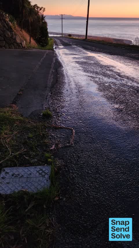
 Water Leak —
 Valve/meter box nearby. Water bubbling from small hole in the seal too...
 Water Leak —
 Leaky water meter
 Water Leak —
 Leak on road outside 350 Mt Pleasant Rd. A lot of water. Similar to what would come out of a hose at medium speed. Water drenching grass ver
 Water Leak —
 Water leak before Toby box
 Water Leak —
 Water leaking out of meter and also out of road approximately 1/2 way across the road.
 Water Leak —
 Water leaking from previously patched roadway outside 350 Mt Pleasant Road. About 3L/min
- Parks —
Grass on road berm is very long just at the start of upper major hornbrook road when you turn onto it from Mt pleasant road. Thanks!
- Roading/Streets —
Signal hill road sign has come loose again on the corner of Mt pleasant and upper major hornbrook road. Thanks Simon
- Roading/Streets —
Signal hill road sign has fallen off the post on the corner of upper major hornbrook road and Mt pleasant road. Thanks!
Also reported on Mount Pleasant Road
- 130 Mount Pleasant Road — 13 reports
- 380 Mount Pleasant Road — 10 reports
- 203 Mount Pleasant Road — 8 reports
- 131 Mount Pleasant Road — 8 reports
- 326 Mount Pleasant Road — 7 reports
- 265 Mount Pleasant Road — 7 reports
- 4 Mount Pleasant Road — 6 reports
- 188 Mount Pleasant Road — 6 reports
The street’s crash record
NZTA’s record names Mount Pleasant Road in 8 crashes that hurt somebody since 2006 — 5 seriously hurt, nobody killed.
The green nearby
- John Britten Reserve — 48 m to the edge · Regional · 35 ha
- Ridgeview Reserve — 287 m to the edge
Parks within half a kilometre, measured to the boundary — the council’s open data.
The named ground
Named places within 1.5 km of this address — the open map’s record.
Renting nearby
new bonds in Mount Pleasant ran about $700 a week — $150 above the city median of $550 — the suburb page keeps the rent record →.
The civic layer
This ground votes in Heathcote ward — the Spreydon-Cashmere-Heathcote community board. Ward lines don’t always follow suburb lines; this one is measured at the pin, not the suburb’s centre.
What stood on this ground → · On the map → · From the air — the Crown’s aerials back to 1936; search the address on RetroLens →
Questions, answered briefly
18 council reports on record since March 2022 — most often graffiti on a fence, building or structure (8), water leak (6), roading/streets (2).
Mount Pleasant, Christchurch — on Mount Pleasant Road.
Nothing on the heritage register at this exact spot — the record around this ground →
John Britten Reserve — 48 m to its edge, 35 ha.