80 b Blake Street, New Brighton
18 reports on record since December 2022 · 15 with photographs. Indicative rating valuation and school zones, hazards, bin day and what stood here before.
What gets reported here
Photographed here 15 on record




Reported here
 Graffiti on a fence, building or structure —
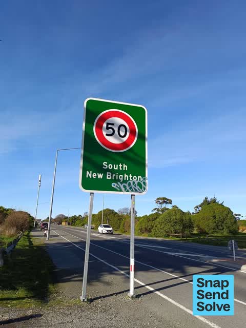
 Blue graffiti on Street sign, and red graffiti on Street sign and fence
 Graffiti on a fence, building or structure —
 Graffiti on concrete around road signs
- Vandalism - General —
The road sign that says South New Brighton has been graffitied.
 Graffiti somewhere else —
 Both signs on bridge st ladder required
 Graffiti on a road, footpath or bridge —
 Please not the location is not blake street, it is Bridge street,new brighton as you enter into south new brighton from Dyers road side,head
 Graffiti somewhere else —
 On the rocks alongside the road just before the bridge
 Graffiti on a road, footpath or bridge —
 On the curb of the road crossing
 Graffiti on a sign, mural or public art —
 On road signs where trail crosses Bridge St
 Graffiti on a cabinet, pole or railway asset —
  Graffiti on a cabinet, pole or railway asset —
  Graffiti on a cabinet, pole or railway asset —
  Graffiti on a sign, mural or public art —
 Heaps of Graffiti between Bridge and Roundabout on Bridge Street in South New Brighton
 Graffiti somewhere else —
 Also just by bridge in bridge st
 Graffiti on a cabinet, pole or railway asset —
  Graffiti on a cabinet, pole or railway asset —
  Park - General Request —
 Access chain needs a new lock, currently open to vehicles
- Road Signage —
- Park - General Request —
The street it is on
The green nearby
- Bridge Reserve — 12 m to the edge · 7 ha
- Blighs Garden — 238 m to the edge · 6 ha
- Rat Island Reserve — 245 m to the edge · 2 ha
- Bexley Wetland — 415 m to the edge · Regional · 15 ha
Parks within half a kilometre, measured to the boundary — the council’s open data.
The tracks through here
- Walk and bike track through New Brighton — 40 m to the line · walk · bike
- Walk and bike track through New Brighton — 51 m to the line · walk · bike
- Walk and bike track through New Brighton — 60 m to the line · walk · bike
- Walk and bike track through New Brighton — 278 m to the line · walk · bike
- Walk and bike track through New Brighton — 396 m to the line · walk · bike
Tracks whose line passes within half a kilometre, measured to the line itself — the council’s open data.
The named ground
Named water within 500 m of this address, measured to the line or the edge; Named places within 1.5 km of this address; the council’s own structure register — bridges, boardwalks and steps standing nearby — the open map’s record.
The remembered names nearby
- Arbor Day 1993 / Planted by Members / of the Second — 55 m away ·
ARBOR DAY 1993 / PLANTED BY MEMBERS / OF THE SECOND / BURWOOD/PEGASUS / COMMUNITY BOARD
· 2003
Inscribed plaques within two hundred and fifty metres — the register’s pins, not surveyed spots. The whole roll is at /plaques.
Renting nearby
new bonds in New Brighton ran about $520 a week — $30 below the city median of $550 — the suburb page keeps the rent record →.
The civic layer
This ground votes in Coastal ward — the Coastal-Burwood-Linwood community board. Ward lines don’t always follow suburb lines; this one is measured at the pin, not the suburb’s centre.
What stood on this ground → · On the map → · From the air — the Crown’s aerials back to 1936; search the address on RetroLens →
Questions, answered briefly
18 council reports on record since December 2022 — most often graffiti on a cabinet, pole or railway asset (5), graffiti somewhere else (3), park - general request (2).
New Brighton, Christchurch — on b Blake Street.
Nothing on the heritage register at this exact spot — the record around this ground →
Bridge Reserve — 12 m to its edge, 7 ha.