60 Vincent Place, Opawa
22 reports on record since August 2022 · 14 with photographs. The street’s heaviest record is 63 Vincent Place — 58 reports on file. Indicative rating valuation and school zones, hazards, bin day and what stood here before.
What gets reported here
Photographed here 14 on record


Reported here
 Dumped Rubbish —
 rubbish lying on roadside by park alongside Brougham motorway between St Vincent Place
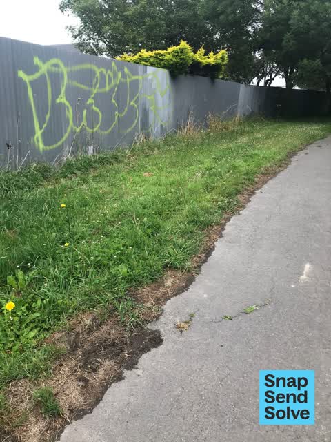
 Graffiti on a fence, building or structure —
 Graffiti on fence
- Graffiti on a fence, building or structure —
Huge white tags on fence slang pedestrian footpath Near corner of Vincent and Brougham
 Graffiti on a fence, building or structure —
  Graffiti on a fence, building or structure —
  Graffiti on a fence, building or structure —
  Dumped Rubbish —
 Wire and old flare hazardous substance explosive device on berm garden outside of number 69. Can this please be removed
 Graffiti on a fence, building or structure —
 - Sewer General —
I think the smell from the fires at the water treatment plant is causing an awful stink around Opawa. I thought this had been sorted.
 Graffiti somewhere else —
 Graffiti right along fence line from Vincent pl to ensors rd along walking trail
 Graffiti on a fence, building or structure —
 The whole stretch from Vincent Pl to Opawa Rd has been hit hard. 10-15 tags all.over rhe fence along Brougham
 Water Leak —
  Graffiti —
  Graffiti —
 On fence along walkway
- Pavement - Damaged —
- Graffiti —
- Flooding —
- Graffiti —
- Graffiti —
- Graffiti —
 Overgrown Vegetation —
 This is at the end of Vincent place by st marks church. The shrubs have overgrown the footpath and the leaves over the length of the walkway
 Overgrown Vegetation —
 This is at the end of Vincent place by st marks church. The shrubs have overgrown the footpath and the leaves over the length of the walkway
Also reported on Vincent Place
- 63 Vincent Place — 58 reports
- 67 Vincent Place — 25 reports
- 63R Vincent Place — 23 reports
- 6 Vincent Place — 9 reports
- 5 Vincent Place — 8 reports
- 16 Vincent Place — 5 reports
- 3 Vincent Place — 3 reports
- 14R Vincent Place — 3 reports
The street’s crash record
NZTA’s record names Vincent Place in 1 crash that hurt somebody since 2006 — 1 person killed, 0 seriously hurt.
The green nearby
- Heathcote Riverbank Reserve — 225 m to the edge
- Risingholme Park — 307 m to the edge · Botanic · 2 ha
- Monro Playground — 385 m to the edge
- Hansen Park — 448 m to the edge · Sports ground · 12 ha
Parks within half a kilometre, measured to the boundary — the council’s open data.
On the doorstep
- Opawa Surgery — 95 m away · Doctors & clinics
- Fish & Chips on Ferry — 95 m away · Fast food
- Opawa Discounter — 102 m away · Dairies & convenience
- Magic Masala — 112 m away · Restaurants
Businesses within four hundred metres, measured at the pin — OpenStreetMap and the council directories.
The bus nearby
The closest Metro stops, within four hundred and fifty metres.
The tracks through here
- Walk and bike track through Opawa — 100 m to the line · walk · bike
- Walk and bike track through Opawa — 109 m to the line · walk · bike
- Walk and bike track through Opawa — 152 m to the line · walk · bike
- Walk and bike track through Opawa — 160 m to the line · walk · bike
- Walk and bike track through Opawa — 168 m to the line · walk · bike
Tracks whose line passes within half a kilometre, measured to the line itself — the council’s open data.
The named ground
Named water within 500 m of this address, measured to the line or the edge; the council’s own structure register — bridges, boardwalks and steps standing nearby — the open map’s record.
Renting nearby
new bonds in Opawa ran about $555 a week — about the city median — the suburb page keeps the rent record →.
What was here — Dwelling and Setting, The Hollies
88 m away · 188 Richardson Terrace · located to ±22 m · the place’s own record →
On the register. Nothing researched here yet.
The civic layer
This ground votes in Heathcote ward — the Spreydon-Cashmere-Heathcote community board. Ward lines don’t always follow suburb lines; this one is measured at the pin, not the suburb’s centre.
What stood on this ground → · On the map → · From the air — the Crown’s aerials back to 1936; search the address on RetroLens →
Questions, answered briefly
22 council reports on record since August 2022 — most often graffiti on a fence, building or structure (7), graffiti (6), overgrown vegetation (2).
Opawa, Christchurch — on Vincent Place.
The heritage register names a place at or beside it — Dwelling and Setting, The Hollies.
Heathcote Riverbank Reserve — 225 m to its edge.