133 Paparoa Street, PAPANUI
44 reports on record since March 2016 · 33 with photographs. The most-reported address on Paparoa Street. Indicative rating valuation and school zones, hazards, bin day and what stood here before.
What gets reported here
- Graffiti, 15
- Roading/Streets, 5
- Graffiti somewhere else, 4
- Dumped Rubbish, 3
- Overgrown Vegetation, 2
- General Request, 2
Photographed here 33 on record


Reported here
 Pavement - Damaged,
 Recently the asphalt on the Papanui Parallel was cut for underground services. It appears when it was re-asphalted for this the asphalt was
 Trees - General,
 Papanui walk/cycleway, tree is blocking all the light from the streetlight, very dark and dangerous when cyclists can’t see you
 Graffiti on a road, footpath or bridge,
 On bridge along walkway behind Paparoa St school
 Graffiti on a fence, building or structure,
 On two structures by waterway Grassmere St walkway cycle way by Paparoa St school
 Overgrown Vegetation,
 The lights on the cycle/walking track are in-closed in the over grown trees. It is very dark and feels unsafe in the early morning and late
 Graffiti on a traffic light pole or cabinet, or wa,
 This must be Waterworks as associated with the waterway behind paparoa St school
 Pavement - General,
 Damaged pavement through Paparoa Street school that is overgrown and riddled with weeds. Of particular concern is the barley grass and convu
 Graffiti on a cabinet, pole or railway asset,
 For this graffiti I’m unsure who these cabinet assets belong to - assuming CCC? Location is near the bridge near Paparoa Street School on t
 Damaged Street Sign,
 Bridge weight limit signage has fallen down
- Dumped Rubbish,
Dumped trolley in stream by shared path. Unsure of which store it belongs too
 Graffiti somewhere else,
 Small red marker post? North West of bridge on walkway behind Paparoa Street school.
 Vandalism - General,
 Trolleys and bike in stream
 Graffiti somewhere else,
 On two utility boxes below walkway bridge by Paparoa Street school
 Graffiti somewhere else,
 On reverse of vehicle weight limit sign by bridge on walkway by Paparoa Street school
 Graffiti somewhere else,
 Green utility box beside bridge on walkway near Rutland reserve behind Paparoa St school
 Dumped Rubbish,
 More dumped rubbish near new road off the cycleway
 Graffiti,
 On back ofv heavy vehicle bridge limit sign near rear of paparoa Street school on walkway
 Graffiti,
 Series of graffiti on bollards and signs at bridge
 Park - General Request,
 There is a Save More trolley in the stream but there isn't a "Save More" option available under abandoned trolley requests.
 Water General,
 The stream needs a really good clear out of rubbish
- Dumped Rubbish,
- Graffiti,
- Graffiti,
- Graffiti,
- Overgrown Vegetation,
- Sediment - Construction,
- Graffiti,
- General Request,
- General Request,
 Graffiti,
 Bollard city end of walkway behind paparoa St school
 Graffiti,
 Another view of utility box below bridge on walkway behind paparoa St school
 Graffiti,
 Two utility boxes below bridge on walkway from Grants Rd to Rutland St by paparoa St school
 Graffiti,
 On bridge supports walkway Grants Rd to Rutland St
 Graffiti,
 Lamppost on walkway from Grants Rd to Rutland St nearing paparoa St school
- Roading/Streets,
Cycle path trip counter not working or absent since the section of path was resurfaced.
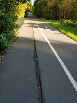 Roading/Streets,
 Cycle way surface has dangerous gap in it, narrow tyres can get caught in it
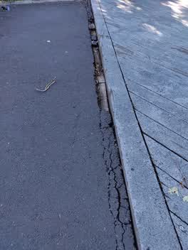 Roading/Streets,
 Edge between bridge and footpath has separated, hazardous to pedestrians and bike riders. This is on the grassmere, paparoa path
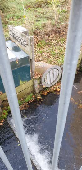 Graffiti,
 outlet pipe? beside bridge on walkway in same area as previously reported also graffiti
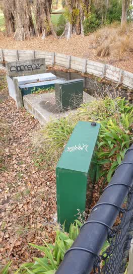 Graffiti,
 beside the bridge in walkway by paparoa St school are utility boxes. three of these have graffiti on them
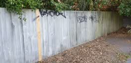 Graffiti,
 on perimeter fence along walkway in paparoa St school near cycleway through to grants road
Graffiti,
on sign by bridge ,(higher up...)
Roading/Streets,
Extreme hazard to cyclists using the Papanui Parallel. Crack approx 25mm in width, will trap tyre of road bike causing wheel lock up, simila
Roading/Streets,
Dangerous 10+ meter long crack in northbound direction along major cycleway just past Dudley creek bridge by Rutland reserve. Now wide enoug
Parks,
Hi guys spotted a decent wasp nest next to the new bike path between paparoa school and grassmere. its in the debris at the bottom of a popl
Also reported on Paparoa Street
- 127 Paparoa Street, 11 reports
- 45 Paparoa Street, 5 reports
- 93 Paparoa Street, 3 reports
- 78 Paparoa Street, 3 reports
- 16 Paparoa Street, 3 reports
- 129A Paparoa Street, 3 reports
- 129 Paparoa Street, 3 reports
- 120 Paparoa Street, 3 reports
From the air, then
Sourced from Canterbury Maps and partners. LINZ, CC BY 3.0 NZ. Each frame is cut from Environment Canterbury’s historic imagery MapServer for that decade, only where the Footprints layer names a CC BY survey (NZAM-covered spots stay out). RetroLens holds more Crown aerials →
The green nearby
- Rutland Reserve, you are in it · 2 ha
- Erica Playground, 212 m to the edge
- Lewisham Reserve, 258 m to the edge
- Papanui Stream Esplanade, 479 m to the edge
Parks within half a kilometre, measured to the boundary, the council’s open data.
The tracks through here
- Walk and bike track through PAPANUI, 3 m to the line · walk · bike
- Walk and bike track through PAPANUI, 61 m to the line · walk · bike
- Walk and bike track through PAPANUI, 68 m to the line · walk · bike
- Walk and bike track through PAPANUI, 163 m to the line · walk · bike
- Walk and bike track through PAPANUI, 418 m to the line · walk · bike
Tracks whose line passes within half a kilometre, measured to the line itself, the council’s open data.
The named ground
Named water within 500 m of this address, measured to the line or the edge; the council’s own structure register, bridges, boardwalks and steps standing nearby, the open map’s record.
Renting nearby
new bonds in PAPANUI ran about $572 a week, $22 above the city median of $550, the suburb page keeps the rent record →.
The civic layer
This ground votes in Papanui ward, the Papanui-Innes-Central community board. Ward lines don’t always follow suburb lines; this one is measured at the pin, not the suburb’s centre.
What stood on this ground → · On the map → · From the air, the Crown’s aerials back to 1936; search the address on RetroLens →
Questions, answered briefly
44 council reports on record since March 2016, most often graffiti (15), roading/streets (5), graffiti somewhere else (4).
PAPANUI, Christchurch, on Paparoa Street.
Nothing on the heritage register at this exact spot, the record around this ground →
Rutland Reserve, the address is inside it, 2 ha.