43 Langdons Road, PAPANUI
70 reports on record since August 2015 · 46 with photographs. The most-reported address on Langdons Road. Indicative rating valuation and school zones, hazards, bin day and what stood here before.
What gets reported here
Photographed here 46 on record


Reported here
 Graffiti on a fence, building or structure —
 On fence post outside Papanui high school by pedestrian rail crossing. Start of walkway
 Graffiti on a fence, building or structure —
 on lamppost by Langdons Rd level crossing. Northlands side
 Graffiti on a fence, building or structure —
 graffiti on light lamp post pole nearby
 Graffiti on a traffic light pole or cabinet, or wa —
 graffiti on traffic control cabinet nearby
 Graffiti on a traffic light pole or cabinet, or wa —
 Traffic signals control box Langdons Rd level crossing
 Graffiti on a fence, building or structure —
 on fence alongside Papanui high school walkway by Langdons Rd level crossing
 Graffiti on a traffic light pole or cabinet, or wa —
 traffic signals control box at Langdons Rd level crossing
 Graffiti on a fence, building or structure —
 tag on guard fence
 Hazard — vehicle —
 graffiti on power box on parking sign
 Graffiti on a traffic light pole or cabinet, or wa —
 graffiti on traffic control cabinet
 Graffiti on a traffic light pole or cabinet, or wa —
 traffic signals control box Langdons Rd level crossing
 Road Signage —
 The train sign on Langdons Road when travelling west is not secured at the base. As a result was not facing the traffic. I did turn it in t
 Graffiti on a road, footpath or bridge —
  Graffiti on a fence, building or structure —
 Wall just over from traffic control cabinet
 Graffiti on a fence, building or structure —
 Graffiti on brown bench seat westside of roundabout
 Graffiti on a fence, building or structure —
 Graffiti on lamp post pole
 Graffiti on a fence, building or structure —
 Graffiti on lamp post closes one to railway line
 Graffiti on a fence, building or structure —
 In fence along railway cycle track by Langdons Rd level crossing by Papanu High school
 Graffiti on a traffic light pole or cabinet, or wa —
 Traffic signals control box Langdons Rd level crossing
 Graffiti somewhere else —
 On exterior of chemist warehouse building along walkway to Restell Street
 Graffiti somewhere else —
 On exterior of chemist warehouse along walkway
 Graffiti somewhere else —
 Exterior of chemist warehouse along walkway
 Graffiti somewhere else —
 On wall of the chemist warehouse along walkway. Additional to previous reports?
 Graffiti somewhere else —
 Exterior chemistry warehouse along walkway
 Graffiti somewhere else —
 On chemist warehouse exterior along walkway behind Restell Street
 Graffiti somewhere else —
 More graffiti on exterior of chemist warehouse along walkway behind Restell Street
 Graffiti somewhere else —
 On exterior of chemist warehouse, along walkway. Near Restell Street
 Graffiti —
 On external wall of chemist warehouse along walkway
 Graffiti —
 Rear wall of Chemist Warehouse Along walkway by railway line
 Water Leak —
 There is a hissing noise coming from drain under Langdon's road next to railway tracks Been going for a while, must be reasonably sized lea
 Graffiti —
 Railway signals control box? By Langdons road level crossing
 Graffiti —
 On sides of bridge visible from chemist warehouse carpark, by Langdons road level crossing
 Graffiti —
 On utility box by Langdons road level crossing
 Graffiti —
 On railway sign Langdons road level crossing
- Water Leak —
- Graffiti —
- Graffiti —
- Graffiti —
- Graffiti —
- Poles and Signage - General —
- Road Signage —
- Graffiti —
- Water Leak —
- Fallen Tree —
- Graffiti —
- Dumped Rubbish —
- Graffiti —
- Graffiti —
- Graffiti —
- Graffiti —
- Graffiti —
- Graffiti —
- Dumped Rubbish —
- Dumped Rubbish —
- Dumped Rubbish —
- Pavement - General —
- Graffiti —
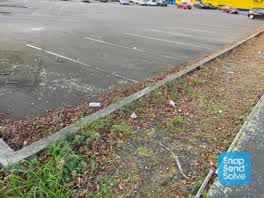 Rubbish/Recycling —
 This area on the cycle track between Chemist Warehouse and Mitre 10 is a constant disgrace with rubbish. To try to help this problem would a
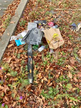 Rubbish/Recycling —
 This area is bad for rubbish. I have collected the smaller stuff. This car park is disgusting. Is the council or Chemist Warehouse responsib
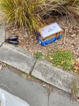 Rubbish/Recycling —
 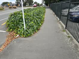 Roading/Streets —
 Ivy is growing well outside the garden bed and is obstructing the footpath. This makes it difficult for people to get prams and strollers, b
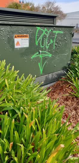 Graffiti —
 orion box opposite entrance to Papanui high school
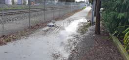 Roading/Streets —
 The pedestrian/Bike pathway passing behind Mitre 10 in Papanui is unpassible after any period of rain due to puddling expanding the entire w
Graffiti —
Graffiti - General —
Roading/Streets —
hole in fence between noel lemmings and railway line
Graffiti —
back of Noel Leeming Papanui
Roading/Streets —
Creeper (ivy?) has collapsed across footpath on Langdons Rd by railway crossing.
Roading/Streets —
Cycle way blocked at road by Langdons
- Roading/Streets —
Light not working on cycleway behind Noel Leeming
Also reported on Langdons Road
- 48 Langdons Road — 65 reports
- 56 Langdons Road — 55 reports
- 35 Langdons Road — 39 reports
- 30 Langdons Road — 38 reports
- 19 Langdons Road — 23 reports
- 61 Langdons Road — 20 reports
- 59 Langdons Road — 15 reports
- 60R Langdons Road — 14 reports
The street’s crash record
NZTA’s record names Langdons Road in 30 crashes that hurt somebody since 2006 — 8 seriously hurt, nobody killed.
The green nearby
- Bridgestone Drainage Reserve — 80 m to the edge · 1 ha
- St James Park — 292 m to the edge · Sports ground · 4 ha
- Marble Wood Reserve — 347 m to the edge
- Papanui Memorial Reserve — 403 m to the edge · Botanic
- Papanui Domain — 414 m to the edge · Sports ground · 3 ha
Parks within half a kilometre, measured to the boundary — the council’s open data.
The civic shelf nearby
- Papanui Library — 99 m away · Library · 35 Langdons Road & Restell Street, Papanui, Christchurch 8053
- Papanui Service Centre — 105 m away · Service centre
Libraries, halls and the rest within half a kilometre — the council’s open data.
On the doorstep
- Launch Pad Trampoline Park — 62 m away · Attractions
- Chemist Warehouse — 63 m away · Pharmacies
- Columbus Coffee — 88 m away · Cafés
- Espresso Car Wash Cafe Northlands — 105 m away · Cafés
Businesses within four hundred metres, measured at the pin — OpenStreetMap and the council directories.
The bus nearby
- Harewood Rd near St James Ave — 239 m away · route 27, route 125, the Orbiter (clockwise)
- Harewood Rd near Matsons Ave — 247 m away · route 27, route 125, the Orbiter (anticlockwise)
The closest Metro stops, within four hundred and fifty metres.
The tracks through here
- Walk and bike track through PAPANUI — 13 m to the line · walk · bike
- Walk and bike track through PAPANUI — 27 m to the line · walk · bike
- Walk and bike track through PAPANUI — 80 m to the line · walk · bike
- Walk and bike track through PAPANUI — 149 m to the line · walk · bike
- Walk and bike track through PAPANUI — 178 m to the line · walk · bike
Tracks whose line passes within half a kilometre, measured to the line itself — the council’s open data.
The named ground
the council’s own structure register — bridges, boardwalks and steps standing nearby — the open map’s record.
Renting nearby
new bonds in PAPANUI ran about $572 a week — $22 above the city median of $550 — the suburb page keeps the rent record →.
What was here — Former Papanui Railway Station and Setting
179 m away · 1 Restell Street · located to ±14 m · the place’s own record →
On the register. Nothing researched here yet.
The civic layer
This ground votes in Papanui ward — the Papanui-Innes-Central community board. Ward lines don’t always follow suburb lines; this one is measured at the pin, not the suburb’s centre.
What stood on this ground → · On the map → · From the air — the Crown’s aerials back to 1936; search the address on RetroLens →
Questions, answered briefly
70 council reports on record since August 2015 — most often graffiti (22), graffiti on a fence, building or structure (10), graffiti somewhere else (8).
PAPANUI, Christchurch — on Langdons Road.
The heritage register names a place at or beside it — Former Papanui Railway Station and Setting.
Bridgestone Drainage Reserve — 80 m to its edge, 1 ha.