45 Grassmere Street, PAPANUI
24 reports on record since January 2017 · 19 with photographs. The most-reported address on Grassmere Street. Indicative rating valuation and school zones, hazards, bin day and what stood here before.
What gets reported here
- Roading/Streets — 4
- Water Leak — 3
- Overgrown Vegetation — 3
- Dumped Rubbish — 3
- Street Light Outage — 2
- Litter — 2
Photographed here 19 on record




Reported here
 Dumped Rubbish —
 thanks for cleaning up the last lot of rubbish. This is a new lot!
 Dumped Rubbish —
 Dumped rubbish
 Dumped Rubbish —
 There is a growing pile of rubbish in the Grassmere Housing development. This rubbish contains food scraps so there will be vermin. Obvious
 Road Signage —
 Road sign had been pushed over or dislodged. There is a hole there where it may have been installed. No damage to sign just knocked over.
 Litter —
 Across one of the entries to the rest home ngaio marsh I have noticed every day people are dumping furniture and other rubbish at the abando
 Water Leak —
 45A Grassmere. Audible sound of leaking and clear rippling of the water escaping the meter ?
 Overgrown Vegetation —
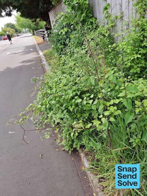
 Suspected Old Man's Beard- noxious weed - on cycle path. Environment Ca.terbury
 Overgrown Vegetation —
 Suspect noxious weeds
 Damaged Street Light —
 Street light not working near the Grassmere driveway for Ngaio Marsh Retirement Village
- Damaged Street Light —
The street light on Grassmere Rd closest to the entry/exit to Ngaio Marsh Retirement Village, on the Grants Rd side of the driveway, is out.
 Street Light Outage —
 Maybe a year ago I reported this light not working. I’m unsure if it was fixed, if it was then it has failed again. Note there is reflecti
 Overgrown Vegetation —
 Further along, more old man's beard, some on council land, but a great crop in flower on private land
 Damaged Road —
 Sunken cover
 Hazard — vehicle —
 Harcourt car in yellow lines and the cycle way. And a sign on the cycleway
 Litter —
 Broken bottle on cycle path, risk of tyre damage
- Damaged Street Sign —
- Street Light Outage —
- Water Leak —
- Water Leak —
Flooding —
Temporary 2-way cycle/walk way flooded. This is a continuing problem and a very unsafe temporary setup. School kids are cycling/walking agai
Roading/Streets —
Unfinished cycleway outside 45 Grassmere rd. Safety markets missing, gravel patch missing asphalt, temp market 'lane' too narrow to allow sa
Roading/Streets —
1/ unsealed broken track way after repairs done MANY months ago which reduces the already narrow lane. 2/ Why is this section of the cycle
Roading/Streets —
New works are in complete
Roading/Streets —
Two areas about 150 metres apart with 7 or 8 holes in asfalt (test holes?). Danger of cyclist vs car accident due to uneven surface and hole
Also reported on Grassmere Street
- 65 Grassmere Street — 16 reports
- 23 Grassmere Street — 8 reports
- 46 Grassmere Street — 7 reports
- 17 Grassmere Street — 7 reports
- 60 Grassmere Street — 6 reports
- 2B Grassmere Street — 6 reports
- 29 Grassmere Street — 6 reports
- 57 Grassmere Street — 4 reports
The street’s crash record
NZTA’s record names Grassmere Street in 17 crashes that hurt somebody since 2006 — 4 seriously hurt, nobody killed.
The green nearby
- Rutland Reserve — 261 m to the edge · 2 ha
- Papanui Stream Esplanade — 269 m to the edge
- Erica Playground — 284 m to the edge
- Shearer Playground — 311 m to the edge
Parks within half a kilometre, measured to the boundary — the council’s open data.
On the doorstep
- Ngaio Marsh Retirement Village — 125 m away · Business
- Bombay Tandoor — 242 m away · Restaurants
Businesses within four hundred metres, measured at the pin — OpenStreetMap and the council directories.
The tracks through here
- Walk and bike track through PAPANUI — 260 m to the line · walk · bike
Tracks whose line passes within half a kilometre, measured to the line itself — the council’s open data.
The named ground
Named water within 500 m of this address, measured to the line or the edge; the council’s own structure register — bridges, boardwalks and steps standing nearby — the open map’s record.
Renting nearby
new bonds in PAPANUI ran about $572 a week — $22 above the city median of $550 — the suburb page keeps the rent record →.
The civic layer
This ground votes in Papanui ward — the Papanui-Innes-Central community board. Ward lines don’t always follow suburb lines; this one is measured at the pin, not the suburb’s centre.
What stood on this ground → · On the map → · From the air — the Crown’s aerials back to 1936; search the address on RetroLens →
Questions, answered briefly
24 council reports on record since January 2017 — most often roading/streets (4), water leak (3), overgrown vegetation (3).
PAPANUI, Christchurch — on Grassmere Street.
Nothing on the heritage register at this exact spot — the record around this ground →
Rutland Reserve — 261 m to its edge, 2 ha.