Forestry Reserve Port Levy
Regional · 3 ha
From the air
Where it sits
Its centre falls inside Port Levy, suburb membership is a centroid call, not a claim the whole park lies inside the outline.
More green in Port Levy
The civic shelf inside
Libraries, toilets, courts and the rest whose point falls inside the park’s drawn outline, the ground in use, the way a register pin is the ground remembered.
- Port Levy Collection Point, Transfer station
The reports on this ground
5 reports pinned inside the park's drawn outline, most often Rubbish & dumping and Trees & parks, 4 with a photograph. A pin is where a reporter stood, not a claim about the whole park.
 Trees - General, 1679 Western Valley Road, Banks Peninsula, Port Levy 8972, New Zealand · 4 August 2025
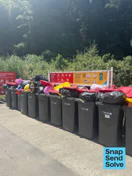 Rubbish and Bins - General, 1679 Western Valley Road, Banks Peninsula, Port Levy 8972, New Zealand · 22 December 2024
- Rubbish and Bins - General, 1679 Western Valley Road, Port Levy 8972, New Zealand · 2 January 2023
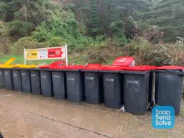 Rubbish/Recycling, 1679 Western Valley Road, Port Levy 8972, New Zealand · 21 June 2022
Parks, 1679, Western Valley Road, Port Levy, 8972, Canterbury · 13 September 2017
Environment Canterbury / Canterbury Maps, Parks layer · refreshed 10 October 2026.
What stood on this ground before → · On the map →
Questions, answered briefly
3 hectares by the layer’s own polygon.
Its centre falls inside Port Levy, a centroid call, not a claim the whole park lies inside the outline.
Regional.
Environment Canterbury’s open Parks layer, kind, size and suburb read straight from it.