
Dumped Rubbish1679 Western Valley Road, Banks Peninsula
Greenwaste has continually been dumped by the road on council land here. It has filled the space and now it is being dumped on the other side of the big pine…
84 council reports since November 2015, the 100th busiest suburb in the city. 66 photographs on record.
The record also holds 2023 Census snapshot· 66 photographs· 3 old photographs· 2 parks· 5 civic facilities· 1 place of worship· 1 marae· 17 names on the map· the record drew water over 16% of the outline· inside the broad slope-instability overlay· the Ngāi Tahu schedule covers 36% of the outline· ecological sites over 3% of the outline· landscape schedules over 82% of the outline· setback strips over 1% of the outline· 5 SCIRT photographs filed on this ground· 2 remembered names on this ground· 4 drawn rules bind this ground· 2 council structures on the register· 1 trees on the register· the plan’s word on this ground· 2 places on the heritage schedule· 87 epicentres inside the outline· 5 injury crashes· 8 recorded victimisations· the council’s fix times· 3 heritage places· 40 documents· 3 mentions on the wire
Link-outs to the source’s own live pages, chch.live does not copy their live values or source text.
The ground: the flood record drew water over 16% of it, the rest of the watch is drawn further down.
Day to day it holds 2 parks, 5 civic facilities, 1 place of worship and 1 marae, each is counted further down.
Lately the record’s mostly roads & footpaths, 11 reports in the year to 13 October 2026, the newest 19 August 2026.
One for the quiz, Its busiest day on record was 21 June 2019, 7 reports in a single day.
About 651 people and 276 occupied private households in the “Banks Peninsula Eastern Bays” and “Diamond Harbour” areas, grouped from 6 SA1 areas. A wider statistical area stands in for this suburb, so this is a proxy rather than a count for the suburb boundary.
Ethnicity is a multiple-response measure, so those percentages are not meant to add to 100%.
Stats NZ’s 2023 Census uses fixed random rounding to base 3. Unavailable or confidential cells are left out, not treated as zero. individuals · households · geography · CC BY 4.0.
Port Levy is a long, sheltered bay and settlement on Banks Peninsula in Canterbury, New Zealand. The current population is under 100, but in the mid-19th century it was the largest Māori settlement in Canterbury with a population of about 400 people. It is named after Solomon Levey, an Australian merchant and ship owner who sent a number of trading vessels to the Banks Peninsula area during the 1820s.
Placed by the record’s locality join or the name in its own title, a lead, not a claim each frame stood here.
Greenwaste has continually been dumped by the road on council land here. It has filled the space and now it is being dumped on the other side of the big pine…

Hey Team Happy Monday can we get this site rail repaired Thanks ??

Someone has dumped a pile of old carpet & carpet underlay. It was down a cliff toward the sea, I have moved it across the road so that it will not fall down…
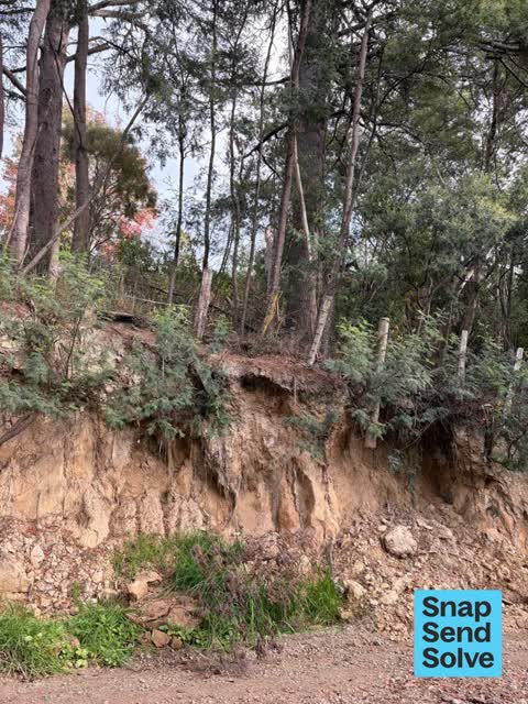
Bank above road, supporting significant trees, continues to erode. Caused by loggers widening the road here.

In the big wind recently this tree broke in pieces across the road, the farmer pushed it to the side with a tractor so they could gain transport access but…

Overgrown wild fennel lining both sides of the road, blocking visibility of road sign and shortly will collapse onto unsealed road, narrowing it

This back continues to collapse and erode. This was reported a couple of years ago, it was dug out by loggers using the road and never properly retained. It…
access to the eastern side of the beach has eroded over the last few years making beach access really difficult particularly for young children and older…

Fence has been repaired. Too high to climb easily over. Needs a stile. The dogs prohibited sign is falling off. Needs replacing. People often taking dogs on…

There are many large trees growing/blocking the stream in front of the ford near 5 Puari Road, Port Levy that need to be removed before the next big rainfall

This large branch fell on Sat and blocked the road. We cleaned it up but 2 further large branches are broken and hanging in a smaller tree overhanging the road…

These trees are leaning dangerously close to 33,000 volt power lines. Tree tech came and cut a few lower branches off and chopped down one fallen tree (as seen…
The median council work order pinned in Port Levy took 6 weeks to resolve, the city-wide median is 3 days, so this ground runs slower than the city as a whole. The slowest tenth waited 6 months or longer. 8 tickets are open here now, the oldest was filed 27 February 2025.
Work orders, not the resident reports above, the council’s MyCouncilTicket stream, and one job can appear in both. A median counts only finished jobs; open ones are named as open, never averaged in. The ticket roll · the whole city’s fix times.
Zoned for Aidanfield Christian School · Christchurch Adventist School · Middleton Grange School · St Thomas of Canterbury College · Villa Maria College · Cashmere High School (part) · and 2 more zones, the drawn zone is indicative; the Ministry’s written scheme is the legal boundary.
Parks and reserves in the council’s open data, a park lands in the suburb its centre falls inside. The whole roll is at /parks.
Libraries, halls, cemeteries and the rest in the council’s open data, a facility lands in the suburb its point or centre falls inside. The whole shelf is at /facilities.
Places of worship in the open map’s record, one lands in the suburb its building stands in. The whole roll is at /worship.
Marae in the region’s roll, a marae stands where it stands; the join names the suburb the roll files it under. The whole roll is at /maraes.
The flood record drew water over 16.1% of this outline, about 1,335 hectares, across 1 named event. A patch is one event’s observation, not a live hazard finding; the whole record is drawn at /floods.
No named slope-hazard band reaches this outline. The broad remaining-instability overlay covers 81% of it besides, the plan’s background watch over the hill country. Shares read from a sampled join; a management overlay, not a prediction. The whole watch is drawn at /slope.
The council’s structure register stands 2 assets on this ground, 1 shelter, 1 jetty, sited at Port Levy Marae. The register’s site names are its own labels for the ground an asset stands in; the layer is drawn at the map.
The register counts 1 living tree inside this outline, 1 veteran among them, mostly Gum. A tree record is the register’s word on what stands or stood; the whole canopy is drawn at /trees.
The plan files 73% of this outline under Rural Banks Peninsula, the rest mostly Papakainga Kainga Nohoanga 7%, Open Space Natural 2%, 82% of the outline fell inside a mapped zone. A zone is a permission, not a description, the mix is read from a sampled join of the plan’s polygons; the whole district is drawn at /zones.
The plan’s heritage schedule protects 2 places by name in this suburb, 1 graded highly significant, St Paul's Church and Setting, Former Little Port Cooper School and Setting. A setting is the ground the item stands in, each files under the suburb holding its centroid; the whole schedule is at /heritage.
The plan’s schedule of sites significant to Ngāi Tahu covers 36% of this outline, about 2,976 hectares, ngā tūranga tūpuna, wāhi tapu/wāhi taonga, ngā wai. A silent-file precinct covers 19% of it besides, sensitive ground the plan flags without naming the sites. Shares read from a sampled join; a recognition overlay, not a catalogue. The whole schedule is drawn at /cultural.
The plan’s ecological schedules cover 3% of this outline, about 283 hectares across 2 scheduled sites, 3% of it Schedule B, identified on private land but not yet protected. Shares read from a sampled join; a recognition overlay, not a survey. The whole ledger is drawn at /ecology.
The plan’s landscape schedules cover 82% of this outline, about 6,802 hectares across 21 scheduled areas, 15% of it outstanding, the plan’s strongest landscape standing, and 11% of it sits inside the coastal environment. 5 main ridgelines run through, the skyline itself is protected. Shares read from a sampled join; a protection overlay, not a ranking of views. The kept view is drawn at /landscape.
The plan’s water-margin layers cross this outline, 67 classified reaches, the plan calling Owhetoro Stream and Te Kawa Stream by name, 1% of it inside the setback strips, the widest holding 10 m off the bank. The margin is the plan’s drawing, not a survey of the bank; the reaches, strips and held edges are mapped at /water-margin.
The plan’s allowed shape holds this outline, 2 hill density lines hold the high ground low. The shape is the plan’s permission, not a survey of what stands; the allowed shape is drawn at /density.
The rebuild’s cameras filed 5 photographs on this ground, stormwater work mostly. Each frame is a receipt the dig left behind, a work log, not a survey of what stands now; the whole record is drawn at /rebuild.
The remembered names stand on this ground, 2 inscribed plaques, Port Levy Former School Site among the grounds. The plaque is the register’s pin, not a surveyed spot; the whole roll is kept at /plaques.
The rulebook binds this ground, 4 drawn instruments, 4 of them dog rules; the outline sits inside the takiwā of Rapaki Runanga, Te Runanga o Koukourarata and Wairewa Runanga. The bylaw is the instrument, this the map of it, the whole rulebook is drawn at /rules.
GeoNet’s catalogue puts 87 magnitude-3+ epicentres inside this outline since the sequence opened, the biggest a M4.9 in 2011. An epicentre is where the instruments placed the break, not a measure of the shaking here; the whole catalogue is counted at /sequence, the live record is /quakes, and the story in plain language is the earthquakes explainer.
The named waterways, bays, headlands, monuments, summits and old sites OpenStreetMap puts inside this outline, a pin is the mapper’s own; a waterway belongs to every suburb it crosses. Every roll, counted: /geography.
5 crashes that hurt somebody on record inside Port Levy's outline, 1 person killed, 1 seriously hurt.
The corner that keeps appearing: Purau Port Levy Road at Western Valley Road, 3 injury crashes, 1 fatal.
8 victimisations on the Police record inside Port Levy’s outline, September 2022–August 2026, mostly burglary, about 3 a year per 1,000 residents. Reported is not all, how much never reaches the record depends on the offence.
What the archive’s sources say about Port Levy, titled for it, turned up by a search for one of its places, or carrying its name in the text. These are leads and citations: the originals live at the provider, linked from each row.
…starting point and numbered 64 on the chief surveyor map no 65 r j p fleming 100 acres in port levy the easternmost bay at the head of the harbour sea frontage and numbered 65 on the chief surveyor ma…Lyttelton Times · Papers Past · National Library of New Zealand · · text held
…er bay sea frontage and numbered 92 on the chief surveyor map no 93 h w keele 60 acres in port levy on the western side frontage to the sia and numbered 93 on the chief surveyor map no 94 c bovcn 50 a…Lyttelton Times · Papers Past · National Library of New Zealand · · text held
…g may obtain an engagement at the rate of 14s the chain by applying to mr cholmondeley at port levy lodgings to be had within half-a-mile of the place of work c w bishop wholesale and ketaiii provisio…Lyttelton Times · Papers Past · National Library of New Zealand · · text held
…n from a point on the northern coast of bank peninsula midway between the eastern head of port levy and the western head of pigeon bay due north and south across bank peninsula until it meets the sea…Lyttelton Times · Papers Past · National Library of New Zealand · · text held
…son isaac thomas heathcote valley merchant cookson c t w newbigen gentleman cooper george port levy labourer coppel edward lyttelton blacksmith cordy john heathcotefann farmer cortner nicholas head of…Lyttelton Times · Papers Past · National Library of New Zealand · · text held
…r christchurch march 10th 1556 otat rpwo valuable mares in foal 1 apply to c cholmoxdeley port levy hphe undersigned beer to inform the pub lie in general that he has for sale at his stores in london…Lyttelton Times · Papers Past · National Library of New Zealand · · text held
…dship had visited otago and called in on his avay here at akaroa okain bay pigeon bay and port levy we are informed that it is dr selwjm intention to avait in the province for at least ten days in exp…Lyttelton Times · Papers Past · National Library of New Zealand · · text held
…ton nov 19th 1857 wanted a smart lad who can milk and fetch cattle apply to c cholmondely port levy wanted a married couple for a station apply to a j alport lyttel ton or to e j lee at mr woodmans pa…Lyttelton Times · Papers Past · National Library of New Zealand · · text held
…nov 19th 1857 f wanted a smart lad who can mifit and figtch cattle apply to g cholmondely port levy l wanted a married couple for a station apply to a jalport lyttelton or to e j lee at mr woodmans pa…Lyttelton Times · Papers Past · National Library of New Zealand · · text held
The rest are a search away, the whole shelf, for the name →
69 more documents came up in searches for Port Levy's places and have not been read yet, a lead is a search result, not a fact, until somebody reads it.
Compare Port Levy with Purau · Diamond Harbour · te-onepoto-taylors-mistake · Charteris Bay · Lyttelton · Scarborough, same record, side by side.
Port Levy is a long, sheltered bay and settlement on Banks Peninsula in Canterbury, New Zealand. The public record holds 84 council reports for it, the first filed in November 2015.
About 651 people and 276 occupied private households (wider SA2 stand-in): grouped from Stats NZ SA1 areas through this site’s suburb join. Indicative, not a LIM.
84 reports on record, most often roads & footpaths (41), trees & parks (24), rubbish & dumping (9). 11 of them in the year to 13 October 2026.
5 injury crashes on the police record inside the suburb’s outline, 1 person killed, 1 seriously hurt. The suburb’s crashes, mapped →
GeoNet’s catalogue puts 87 magnitude-3+ epicentres inside the suburb’s mapped outline since the September 2010 mainshock, the biggest a M4.9 in 2011. An epicentre is where the instruments placed the break, not a measure of the shaking felt here. The whole sequence, counted → · The story, in plain language →
The heritage register holds 3 places here, Former Little Port Cooper School and Setting, Quarantine Cemetery among them. The written record goes back further: the shelf, for the name →
Every suburb in Christchurch → · Its decade, charted → · the whole A–Z →
Work orders, not the resident reports above, the council’s MyCouncilTicket stream, and one job can appear in both. A median counts only finished jobs; open ones are named as open, never averaged in. The ticket roll · the whole city’s fix times.
The council’s bylaw zones and the Local Alcohol Policy’s buffer list, read from the Regulatory open-data service. A ban rules drinking in public places; it says nothing about whether a premises may sell, that is the licence register’s job.
Ministry of Education directory, the final decile and the current Equity Index describe the community a school draws from, not how well it teaches. Zones are indicative; the written enrolment scheme rules.
Parks and reserves in the council’s open data, the park lands in the suburb its centre falls inside; one that straddles the line keeps its own address.
Libraries, halls, cemeteries and the rest in the council’s open data, a facility lands in the suburb its point or centre falls inside.
Places of worship in the open map’s record, one lands in the suburb its building stands in. The whole roll is at /worship.
Marae in the region’s roll, a marae stands where it stands; the join names the suburb the roll files it under. The whole roll is at /maraes.
Walking, biking, horse and off-road tracks in the council’s open data, a line belongs to every suburb it passes through.
OpenStreetMap’s own record, inside this outline, a pin is the mapper’s; a waterway belongs to every suburb it crosses. Every roll, counted: /geography.
Heritage places the council’s district plan or Heritage New Zealand list inside this suburb, each with what is known about it and the document it is known from.
The register’s era records for places in this suburb, what stood on the ground, and when.
Each of these is a decade of reports, the heritage places on the register, what is known about them, and the documents behind it, everything the archive holds about the part of the city it names.