157 McCormacks Bay Road
10 council reports since February 2024, 10 carrying a photograph. The street’s heaviest record is 120 McCormacks Bay Road, 24 reports on file.
On the register here
- Te Ana o Hineraki/Moa Bone Point Cave and Setting, 8A Balmoral Lane (149m)
From the air, then
Sourced from Canterbury Maps and partners. RNZAF, CC BY 3.0 NZ. Each frame is cut from Environment Canterbury’s historic imagery MapServer for that decade, only where the Footprints layer names a CC BY survey (NZAM-covered spots stay out). RetroLens holds more Crown aerials →
The green nearby
- Mccormacks Bay, 18 m to the edge · Sports ground · 22 ha · playground, 41 pieces
- Redcliffs Park, 97 m to the edge · Sports ground · 2 ha
- Balmoral Hill Reserve, 369 m to the edge · playground, 8 pieces
Parks within half a kilometre, measured to the boundary, the council’s open data. The whole roll is at /parks.
The bus nearby
The closest Metro stops, within four hundred and fifty metres.
The tracks through here
- Walk and bike track through Redcliffs, 3 m to the line · walk · bike
Tracks whose line passes within half a kilometre, the council’s open data.
The named ground
Named water within 500 m of this address, measured to the line or the edge; Named places within 1.5 km of this address; the council’s own structure register, bridges, boardwalks and steps standing nearby, the open map’s record.
The remembered names nearby
- Donated by the Family of Dennis and Eilene Watson, 205 m away ·
DONATED BY THE FAMILY OF DENNIS AND EILENE WATSON / LOCAL RESIDENTS SINCE 1954 / 'We are t
· 2007
Inscribed plaques within two hundred and fifty metres, the register’s pins, not surveyed spots. The whole roll is at /plaques.
Renting nearby
new bonds in Redcliffs ran about $700 a week, $150 above the city median of $550, the suburb page keeps the rent record →.
What gets reported here
Photographed here 10 on record
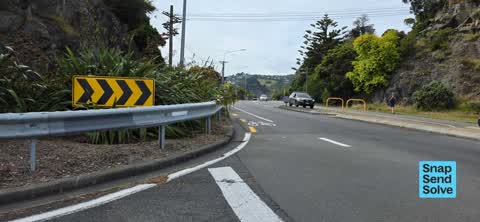


What’s on record
 Overgrown Vegetation, 22 Nov 2025
 Overgrown vegetation that is obstructing the view causing one to move forward into.the oncoming traffic being extremely dangerous and high r
 Pothole, 23 Mar 2025
 Major pot hole that is about 3m long about 200mm deep and 700mm wide. Getting dangerous when turning. I have asked to have it fixed before X
 Damaged Road, 24 Feb 2025
 It doesn’t look much but this pothole throws all the occupants of a car all over the place when turning right from McCormack’s Bay Road onto
 Pothole, 23 Feb 2025
 This pot hole is getting dangerous. I have called CCC and they said it was booked in for repair. This has been months. It’s turning tarfic w
 Damaged Road, 16 Feb 2025
 This pot hole has been like this for about 3 months and getting dangerous when cars are turning onto main road . Especially when cyclists ar
 Damaged Road, 1 Dec 2024
 Pot hole getting dangerous. A long line about 400mm wide by 3m long.
 Damaged Road, 20 Nov 2024
 Sink hole as you cross the road. Getting bad as it’s a tight corner. Dangerous when ther is a cyclist
 Pavement - Damaged, 5 Nov 2024
 Substantial failure in traffic lane at intersection has now subsided approximately 50mm in recent weeks
 Graffiti somewhere else, 4 May 2024
 On the corner around main road beach ville road there roughly 6 or so lamppost with lights on them that have graffiti on them
 Pavement - General, 15 Feb 2024
 These old pipes and bits of concrete were left at the corner of McCormacks Bay after the earthquake works. Please could they be removed as t
Elsewhere on McCormacks Bay Road
- 120 McCormacks Bay Road, 24 reports
- 156 McCormacks Bay Road, 21 reports
- 150 McCormacks Bay Road, 21 reports
- 134 McCormacks Bay Road, 9 reports
- 154 McCormacks Bay Road, 6 reports
- 141 McCormacks Bay Road, 6 reports
- 124 McCormacks Bay Road, 6 reports
- 122 McCormacks Bay Road, 6 reports
The street’s crash record
NZTA’s record names McCormacks Bay Road in 5 crashes that hurt somebody since 2006, 1 seriously hurt, nobody killed.
The civic layer
This ground votes in Heathcote ward, the Spreydon-Cashmere-Heathcote community board is its local layer. Ward lines don’t always follow suburb lines; this one is measured at the pin, not the suburb’s centre. The whole roll is at /wards.
McCormacks Bay Road, the whole record → · Everything about Redcliffs → · What stood on this ground → · On the map → · From the air, RetroLens holds the Crown’s aerials back to 1936; search the address there →
Questions, answered briefly
10 council reports on record since February 2024, most often damaged road (4), pothole (2), pavement - general (1).
Redcliffs, Christchurch, on McCormacks Bay Road.
The heritage register names a place at or beside it, Te Ana o Hineraki/Moa Bone Point Cave and Setting.
Mccormacks Bay, 18 m to its edge, 22 ha.