81 Main Road, Redcliffs
21 reports on record since January 2023 · 8 with photographs. The street’s heaviest record is 202A Main Road — 69 reports on file. Indicative rating valuation and school zones, hazards, bin day and what stood here before.
What gets reported here
Photographed here 8 on record


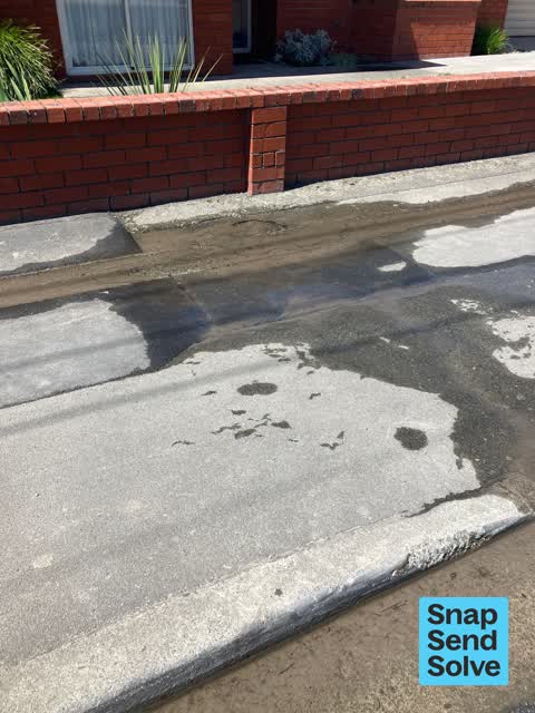


Reported here
 Damaged Street Sign —
 No sign on cross walk
 Pavement - Damaged —
 Pothole on path to level fill & seal
 Road Signage —
 Sign left on pavement after repairs
 Water Leak —
  Water Leak —
 Another leak..
 Water Leak —
 Water running like a turned on tap out of pavement
 Water Leak —
  Water Leak —
 Water leak at water meter
- Water Leak —
- Water Leak —
- Water Leak —
- Water Leak —
- Water Leak —
- Street Gutters / Storm Water —
- Water Leak —
- Water Leak —
- Water Leak —
- Water Leak —
- Water Leak —
- Water Leak —
- Water Leak —
Also reported on Main Road
- 202A Main Road — 69 reports
- 202 Main Road — 23 reports
- 1 Main Road — 22 reports
- 200A Main Road — 20 reports
- 41 Main Road — 15 reports
- 59 Main Road — 13 reports
- 150 Main Road — 13 reports
- 128 Main Road — 12 reports
The street’s crash record
NZTA’s record names Main Road in 38 crashes that hurt somebody since 2006 — 1 person killed, 11 seriously hurt.
The green nearby
- Beachville Reserve — 110 m to the edge
- Moncks Cave Reserve — 221 m to the edge
- Barnett Park Sports Grounds — 270 m to the edge · Sports ground · 8 ha
Parks within half a kilometre, measured to the boundary — the council’s open data.
On the doorstep
- Butterfly and Scotch — 21 m away · Butchers
- Money Bags — 25 m away · Restaurants
- Redcliffs Dairy — 34 m away · Dairies & convenience
- BP2Go Redcliffs — 47 m away · Petrol stations
Businesses within four hundred metres, measured at the pin — OpenStreetMap and the council directories.
The bus nearby
The closest Metro stops, within four hundred and fifty metres.
The tracks through here
- Walk and bike track through Redcliffs — 8 m to the line · walk · bike
Tracks whose line passes within half a kilometre, measured to the line itself — the council’s open data.
The named ground
Named places within 1.5 km of this address; the council’s own structure register — bridges, boardwalks and steps standing nearby — the open map’s record.
The remembered names nearby
- Presented by / the Lions Club / [ Place Name] — 95 m away ·
PRESENTED BY / THE LIONS CLUB / [illegible place name]
· 1899 - In Memory of / Shirley Williams — 100 m away ·
IN MEMORY OF / SHIRLEY WILLIAMS / OUR VOICE, TENACIOUS & BRAVE / FOR THE COMMUNITY
· 1899 - In Memory of / David Cox / Advocate, Friend & Member — 101 m away ·
IN MEMORY OF / DAVID COX / ADVOCATE, FRIEND & MEMBER OF / RICHMOND VILLAGE GREEN
· 1899
Inscribed plaques within two hundred and fifty metres — the register’s pins, not surveyed spots. The whole roll is at /plaques.
Renting nearby
new bonds in Redcliffs ran about $700 a week — $150 above the city median of $550 — the suburb page keeps the rent record →.
What was here — Commercial Building and Setting
87 m away · 186 Main Road · located to ±9 m · the place’s own record →
On the register. Nothing researched here yet.
What was here — Monck's Cave and Setting
233 m away · 2 Moncks Spur Road · located to ±28 m · the place’s own record →
On the register. Nothing researched here yet.
The civic layer
This ground votes in Heathcote ward — the Spreydon-Cashmere-Heathcote community board. Ward lines don’t always follow suburb lines; this one is measured at the pin, not the suburb’s centre.
What stood on this ground → · On the map → · From the air — the Crown’s aerials back to 1936; search the address on RetroLens →
Questions, answered briefly
21 council reports on record since January 2023 — most often water leak (17), street gutters / storm water (1), road signage (1).
Redcliffs, Christchurch — on Main Road.
The heritage register names 2 places at or beside it — Commercial Building and Setting, Monck's Cave and Setting.
Beachville Reserve — 110 m to its edge.