206 Main North Road, Redwood
24 reports on record since May 2022 · 14 with photographs. The street’s heaviest record is 339 Main North Road — 50 reports on file. Indicative rating valuation and school zones, hazards, bin day and what stood here before.
What gets reported here
- Roading/Streets — 6
- Road Signage — 4
- Roads - General — 3
- Pothole — 2
- Street Light Outage — 1
- Street Gutters / Storm Water — 1
Photographed here 14 on record




Reported here
 Facility - General Request —
 Real estate sign has blown over and smashed fence at ccc facility
 Road Signage —
 This bus lane sign on the corner of Queen Elizabeth II Drive and Main North Road has been rotated. Can it please be turned back so it faces
 Street Gutters / Storm Water —
 There has been earthworks done at the property near 204 Main North Road. I’m guessing a material mesh to capture sediment was put in the sto
 Graffiti on a fence, building or structure —
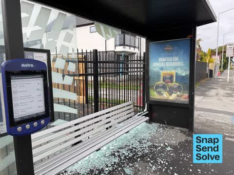
  Bus Shelter Issue —
 Someone has broken the glass at the bus shelter on the east side of Main North Road opposite Pak’nSave.
 Graffiti somewhere else —
 On the corner across the school
 Roads - General —
 The green traffic lights on the pole closest to St Bede’s for traffic heading east are not working. See photo. The orange and red lights a
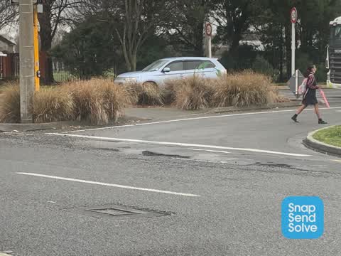
 Pothole —
 Kia ora Team, I understand it is a work site around QE II Drive and Main North Road intersection and it is a 30 km/h location. However ther
 Pavement - General —
 New fill for cut has left a sharp edge which is not good for skinny bike tyres and toes
- Roads - General —
The turning arrow for westbound traffic turning right off QE2 drive onto Main North Road northbound is not changing from red. After sitting
- Graffiti —
- Overgrown Vegetation —
- Road Signage —
- Road Signage —
- Roads - General —
Traffic lights out. Green lights now showing on east side of intersection. Only one set of three are working correctly
- Road Signage —
I don’t have a photo, because I’m always driving my car when I notice this. When you are driving east on Northcote Road, the green light in
- Pothole —
The re-occurance of pot holes in this location is again getting to the point where tire or wheel damage is likely to occure. This is a majo
 Roading/Streets —
 Dangerous pothole when driving off QE11 Drive left onto Main North Road.
 Roading/Streets —
 Green light not showing for eastbound traffic at QEII / Main North Rd, the secondary lights in the median strip. First reported over a month
 Roading/Streets —
 In front of the left turning lane the road is very uneven with holes in the road. Also a pot hole going back towards QEII beside St Bedes no
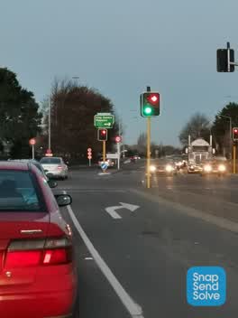 Roading/Streets —
 Green light heading east has been out for a couple of weeks. (Back traffic light)
- Street Light Outage —
Green lights not working heading east on Nortcote Rd
- Roading/Streets —
Cycle path alongside QE 2 drive opposite St Bedes is covered with leaves. Badly needs clearing before they get wet and slippery.
 Roading/Streets —
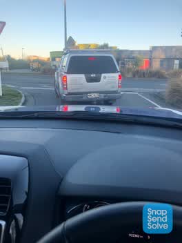
 The left hand turn from QE2 Drive into Main North Rd is extremely rutted & has a large pot hole. I imagine it’s pretty dangerous for cyclist
Also reported on Main North Road
- 339 Main North Road — 50 reports
- 341 Main North Road — 27 reports
- 482F Main North Road — 20 reports
- 343 Main North Road — 17 reports
- 176 Main North Road — 13 reports
- 339A Main North Road — 12 reports
- 337 Main North Road — 11 reports
- 191 Main North Road — 11 reports
The street’s crash record
NZTA’s record names Main North Road in 86 crashes that hurt somebody since 2006 — 16 seriously hurt, nobody killed.
The green nearby
- Ramore Reserve — 184 m to the edge
- Papanui Pool Reserve — 236 m to the edge · Sports ground
- Momorangi Reserve — 374 m to the edge
- Paddington Playground — 430 m to the edge · 1 ha
Parks within half a kilometre, measured to the boundary — the council’s open data.
On the doorstep
- Oil Changers — 89 m away · Car repair
- Abbella Lodge Motel — 92 m away · Motels
- PAK 'n Save Papanui — 110 m away · Supermarkets
- Northcote Dental Clinic — 162 m away · Dentists
Businesses within four hundred metres, measured at the pin — OpenStreetMap and the council directories.
The bus nearby
- Main North Rd near Queen Elizabeth II Dr — 35 m away · route 1, route 95, route 107, route 125
- Main North Rd near Cranford St — 201 m away · route 1, route 107, route 125, route 95
The closest Metro stops, within four hundred and fifty metres.
The tracks through here
- Walk and bike track through Redwood — 16 m to the line · walk · bike
- Walk and bike track through Redwood — 30 m to the line · walk · bike
- Walk and bike track through Redwood — 36 m to the line · walk · bike
- Walk and bike track through Redwood — 338 m to the line · walk · bike
Tracks whose line passes within half a kilometre, measured to the line itself — the council’s open data.
Renting nearby
new bonds in Redwood ran about $542 a week — about the city median — the suburb page keeps the rent record →.
The civic layer
This ground votes in Papanui ward — the Papanui-Innes-Central community board. Ward lines don’t always follow suburb lines; this one is measured at the pin, not the suburb’s centre.
What stood on this ground → · On the map → · From the air — the Crown’s aerials back to 1936; search the address on RetroLens →
Questions, answered briefly
24 council reports on record since May 2022 — most often roading/streets (6), road signage (4), roads - general (3).
Redwood, Christchurch — on Main North Road.
Nothing on the heritage register at this exact spot — the record around this ground →
Ramore Reserve — 184 m to its edge.