
Pavement - Damaged82 Winters Rd
The asphalt has sunk/broken in a small section to the side of the footpath. Raising this because it is not too far from Papanui Primary School and students…
4,969 council reports since June 2015, the 28th busiest suburb in the city. 3,956 photographs on record. 8,400 people at the 2023 Census, 1,917 to the square kilometre across 4.4 km².
The record also holds about $542 a week to rent· 2023 Census snapshot· 3,956 photographs· 1 old photograph· 2 schools· 16 parks· 1 civic facility· 2 places of worship· 12 tracks· 2 names on the map· 3.4% of the outline mapped liquefied· graded mostly TC2 in 2011· the record drew water over 20% of the outline· the Ngāi Tahu schedule covers 1% of the outline· ecological sites over 2% of the outline· landscape schedules over 1% of the outline· noise overlays over the whole outline· setback strips over 3% of the outline· 3% of the outline inside the plan’s density overlays· 1,355 SCIRT photographs filed on this ground· 15.9 km of cycleway crosses the outline· 2 remembered names on this ground· 7 drawn rules bind this ground· 5 parcels on the dangerous-work register· 213 parcels of made ground· the 2019 model grades this ground mostly possible· 15 council structures on the register· 14 recreation register records· 2,688 trees on the register· the plan’s word on this ground· 19% of the outline reserved· 1 epicentre inside the outline· 271 injury crashes· 1,415 recorded victimisations· 34 bus stops· 80 businesses· the council’s fix times· 40 documents· 3 mentions on the wire
Link-outs to the source’s own live pages, chch.live does not copy their live values or source text.
New bonds here ran at about $542 a week in the April–June 2026 quarter, the middle half of them between $395 and $610, across 39 bonds lodged, down 5% on a year ago. That’s in line with the city’s own quarter median of $550. Tenancy Services counts these under the Redwood North, Redwood West and Redwood East areas combined, approximately this suburb.
Median and quartiles of weekly rents on new private bonds, by quarter; suburb figures are a bond-weighted blend of the areas. New bonds are fresh lodgements, not the whole rental stock; under five bonds the rent is withheld, and counts are randomly rounded. Source: Tenancy Services rental bond data: provisional while the bond system migrates.
The ground: the February 2011 survey drew liquefaction over 3% of it; the 2011 grading filed it mostly TC2, the rest of the watch is drawn further down.
Day to day it holds 2 schools, 16 parks, 1 civic facility, 2 places of worship, 12 tracks and 34 bus stops, each is counted further down.
Lately the record’s mostly graffiti & vandalism, 858 reports in the year to 12 October 2026, the newest 11 October 2026.
One for the quiz, Its busiest day on record was 7 January 2020, 13 reports in a single day.
About 8,079 people and 3,075 occupied private households in the “Redwood North”, “Redwood East” and “Redwood West” areas, grouped from 56 SA1 areas. Several statistical areas are combined here, so this is a grouped proxy rather than a count for one suburb boundary.
Ethnicity is a multiple-response measure, so those percentages are not meant to add to 100%.
Stats NZ’s 2023 Census uses fixed random rounding to base 3. Unavailable or confidential cells are left out, not treated as zero. individuals · households · geography · CC BY 4.0.
Redwood is a northern suburb of Christchurch, New Zealand, which includes the sub-division of Redwood Springs. It is bordered by the Styx River to the north. Before the area was settled the original forest cover was tōtara and kahikatea. Like much of Christchurch, the early settlers drained the swamps and cut the bush to create farmland.
Placed by the record’s locality join or the name in its own title, a lead, not a claim each frame stood here.
The asphalt has sunk/broken in a small section to the side of the footpath. Raising this because it is not too far from Papanui Primary School and students…

road works sign appears to have been forgotten about. had CCW on the back. Christchurch City Water? has been there some months

Concrete broken on kerb road side. Outside 23a Grimseys Rd, Redwood


Someone please to sweep the road urgently by 150 Grimseys road, Redwood. All the cones has been removed today, but left all the gravels and create so much…

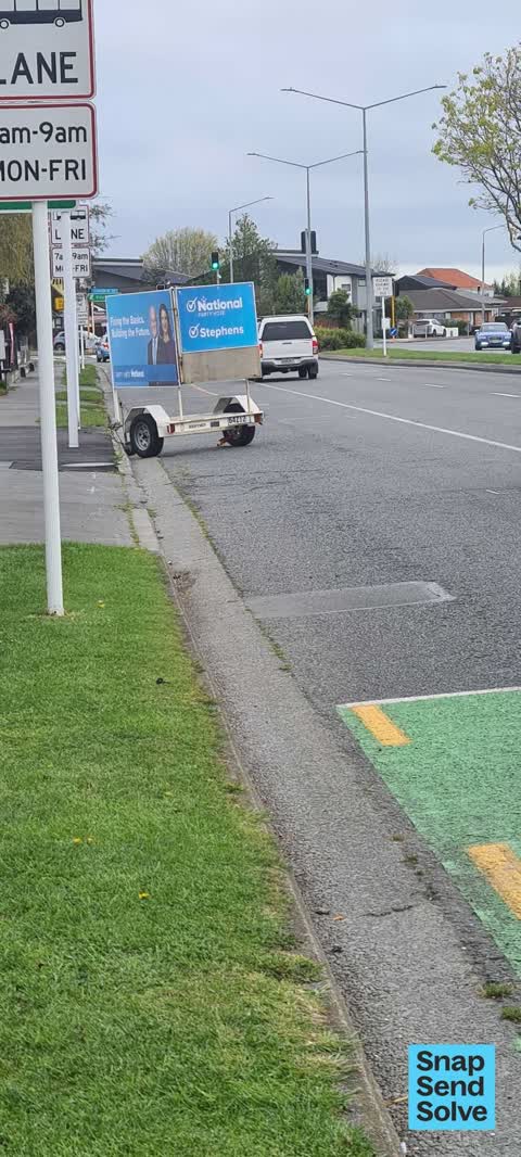
This political advert on a trailer is packed inside the bus lane and parked facing outward and reduces visibility of people leaving the lane it is parked next…

Drivers keep driving on the berm and have carved out some holes making it uneven. Any chance this could be fixed. It has been like this for ages. This…
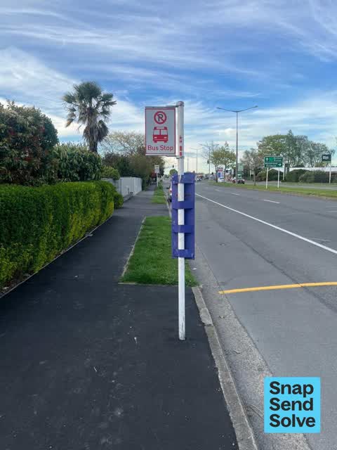
Looks like this bus stop pole is too low… normally these signs are higher so people cannot hit their head on them. Can this please be reviewed, if it is ok…

You may need to review this fix before it is asphalted. Have walked past a few times since the fix and the fill looks wet… there may still be a leak?
The median council work order pinned in Redwood took 4 days to resolve, the city-wide median is 3 days, so this ground runs slower than the city as a whole. The slowest tenth waited 3 months or longer. 265 tickets are open here now, the oldest was filed 14 May 2021.
Work orders, not the resident reports above, the council’s MyCouncilTicket stream, and one job can appear in both. A median counts only finished jobs; open ones are named as open, never averaged in. The ticket roll · the whole city’s fix times.
4 sensitive sites stand here, Papanui Primary School, Redwood School, St Bede's College, Te Kura o Matarangi - Northcote School, and the Local Alcohol Policy restricts new off-licences within 200 m of them.
The council’s bylaw zones and the Local Alcohol Policy’s buffer list, read from the Regulatory open-data service. A ban rules drinking in public places; it says nothing about whether a premises may sell, that is the licence register’s job.
Zoned for Casebrook Intermediate · Christchurch Adventist School · Emmanuel Christian School · Marian College · Middleton Grange School · Papanui High School · and 9 more zones, the drawn zone is indicative; the Ministry’s written scheme is the legal boundary.
Decile and EQI describe the community a school draws from, not how well it teaches.
The first eight of 16, Parks and reserves in the council’s open data, a park lands in the suburb its centre falls inside. The whole roll is at /parks.
Libraries, halls, cemeteries and the rest in the council’s open data, a facility lands in the suburb its point or centre falls inside. The whole shelf is at /facilities.
Places of worship in the open map’s record, one lands in the suburb its building stands in. The whole roll is at /worship.
The first eight of 12, Tracks in the council’s open data, a line belongs to every suburb it passes through. The whole network is at /tracks.
The February 2011 survey drew mapped ground failure over 3.4% of this outline, about 15 hectares. A patch is a footprint, not a finding about an address; the count for the whole city is at /liquefaction.
The 2011 grading filed 105.1% of this outline, about 461 hectares, mostly TC2, with TC3 16 ha · TC2 445 ha. A graded area files under the suburb its middle sits in, and a category is a verdict for a patch of ground, not a finding about an address; the grades are drawn at /technical-categories.
The flood record drew water over 20.0% of this outline, about 88 hectares, across 1 named event. A patch is one event’s observation, not a live hazard finding; the whole record is drawn at /floods.
5 parcels inside this outline sit on the hazardous-activities register, mostly chemical manufacture, application and bulk storage, vehicle refuelling, service and repair, mineral extraction, refining and reprocessing, storage and use, 3 still doing the work. A listing records the work, not a soil test; the whole register is drawn at /hazards.
The files record 213 parcels of made or characterised ground inside this outline, about 48 hectares, mostly peat, engineered fill, topsoil, 2 carry fill the file can’t vouch for. A record is the file’s word on what was laid, not a fresh survey; the whole layer is drawn at /fill.
The 2019 liquefaction study put 54% of this outline in the possible class. A class is the model’s verdict on a patch of ground, not a finding about an address; the whole study is drawn at /vulnerability.
The council’s structure register stands 15 assets on this ground, 6 boardwalks, 4 bridges, 2 ramps, 2 viewing platforms, sited at Styx River Conservation Reserv, Murchison Park, Owen Mitchell Park, Redwood Park. The register’s site names are its own labels for the ground an asset stands in; the layer is drawn at the map.
The recreation register keeps 14 records inside this outline, bookable surfaces for 6 tennis, 6 football, 2 cricket. Seasons and surfaces are the register’s record, not this week’s draw; the layer is drawn at the map.
The register counts 2,688 living trees inside this outline, 7 veterans among them, 57 carrying a protection, mostly Ribbonwood, Silver Birch, Sweet Gum. The file remembers 1,200 trees felled here. A tree record is the register’s word on what stands or stood; the whole canopy is drawn at /trees.
The plan files 46% of this outline under Residential Suburban, 67% residential, the rest mostly Transport 18%, Residential New Neighbourhood 17%. A zone is a permission, not a description, the mix is read from a sampled join of the plan’s polygons; the whole district is drawn at /zones.
The plan reserves about 81 hectares of this outline, 19%, under 10 designations, mostly movement, learning. A designation is a claim on the ground, not a build date, the mix is read from a sampled join; the whole register is drawn at /designations.
The plan’s schedule of sites significant to Ngāi Tahu covers 1% of this outline, ngā wai. Shares read from a sampled join; a recognition overlay, not a catalogue. The whole schedule is drawn at /cultural.
The plan’s ecological schedules cover 2% of this outline, about 7 hectares across 1 scheduled site, all protected under Schedule A. Shares read from a sampled join; a recognition overlay, not a survey. The whole ledger is drawn at /ecology.
The plan’s landscape schedules cover 1% of this outline across 1 scheduled area. Shares read from a sampled join; a protection overlay, not a ranking of views. The kept view is drawn at /landscape.
No high-hazard flood area covers this outline. The broader flood-management watch covers 31% of it, Lower Styx River, Avon River. 1 ponding spot is mapped here, where the models expect water to sit. Shares read from a sampled join; a model’s map, not a promise. The waiting water is drawn at /flood-hazard.
The plan’s noise overlays cover all of this outline, about 438 hectares across 1 mapped overlay, and inside the airport’s bird-strike buffer. Shares read from a sampled join; a planning line, not a meter’s reading. The quiet lines are drawn at /noise.
The plan’s water-margin layers cross this outline, 53 classified reaches, the plan calling Prestons Creek and Horners Drain by name, 3% of it inside the setback strips, the widest holding 20 m off the bank, and an esplanade line holds a public edge here. The margin is the plan’s drawing, not a survey of the bank; the reaches, strips and held edges are mapped at /water-margin.
The plan’s allowed shape holds this outline, 3% of it inside the residential overlays, the densest standing New Neighbourhood. The shape is the plan’s permission, not a survey of what stands; the allowed shape is drawn at /density.
The rebuild’s cameras filed 1,355 photographs on this ground, 2010–2014, wastewater work mostly. Each frame is a receipt the dig left behind, a work log, not a survey of what stands now; the whole record is drawn at /rebuild.
The pedal network threads this ground, 15.9 km of cycleway crosses the outline, 1.1 km of it separated from the traffic, Northern Line. A segment counts under every suburb its path enters; the whole network is drawn at /cycleways.
The remembered names stand on this ground, 2 inscribed plaques, Murchison Park, Owen Mitchell Park among the grounds. The plaque is the register’s pin, not a surveyed spot; the whole roll is kept at /plaques.
The rulebook binds this ground, 7 drawn instruments, 7 bottle-store buffers; the outline sits inside the takiwā of Te Ngai Tuahuriri Runanga. The bylaw is the instrument, this the map of it, the whole rulebook is drawn at /rules.
GeoNet’s catalogue puts 1 magnitude-3+ epicentre inside this outline since the sequence opened, the biggest a M3.3 in 2010. An epicentre is where the instruments placed the break, not a measure of the shaking here; the whole catalogue is counted at /sequence, the live record is /quakes, and the story in plain language is the earthquakes explainer.
The named waterways, bays, headlands, monuments, summits and old sites OpenStreetMap puts inside this outline, a pin is the mapper’s own; a waterway belongs to every suburb it crosses. Every roll, counted: /geography.
271 crashes that hurt somebody on record inside Redwood's outline, 5 people killed, 51 seriously hurt.
The corner that keeps appearing: Cranford Street at Fraser Street, 16 injury crashes, 2 fatal.
1,415 victimisations on the Police record inside Redwood’s outline, September 2022–August 2026, mostly theft, about 44 a year per 1,000 residents. Up 18% on the year before. Reported is not all, how much never reaches the record depends on the offence.
34 Metro stops inside Redwood's outline, in ECan’s stop record, served by route 125, route 1, route 95, route 107, route 27, the Orbiter (anticlockwise), the Orbiter (clockwise).
80 premises in Redwood across 34 kinds, from OpenStreetMap, the council’s licensed-premises register and its 2024 Find Christchurch directory. Each kind below opens at this suburb’s shelf.
Among them, the ones the record says most about:
What the archive’s sources say about Redwood, titled for it, turned up by a search for one of its places, or carrying its name in the text. These are leads and citations: the originals live at the provider, linked from each row.
…ast nelson races and was the favourite for the victualler purse of three miles against mr redwood celebrated horse glaucus and mr newcome horse joe miller but he broke down in the race from an injury…Lyttelton Times · Papers Past · National Library of New Zealand · · text held
…mber verandah at the front. John also built stables on his land, which he leased to Henry Redwood from around 1868. In 1874 Redwood bought the entire property and named it Chokebore Lodge after a type…The New Zealand Heritage List/Rārangi Kōrero · Heritage New Zealand Pouhere Taonga · 1856
…ariel brigantine 139 eves for sydney passengersmrs eves mr melville mr and mrs whiting mr redwood captain pattle and 9 in the steerage imports palmyra from london via otagol276 rails 850 iron sleepers…Colonist · Papers Past · National Library of New Zealand · · text held
…and mrs e moorhouse mrs robinson the misses brathwaite and palmer messrs reynolds leckie redwood raymond a j smith pharuzyn watson mcdonald white somerville dogherty turnbull jones brown whitaker bow…Lyttelton Times · Papers Past · National Library of New Zealand · · text held
…ay the maiden stakes of 100 added to a sweepstakes of 6 each 13 subscribers was won by mr redwood nelson mare waimea beating five others the distance was if miles and the time 2 mm 54 sees the lottery…Lyttelton Times · Papers Past · National Library of New Zealand · · text held
…le the following thoroughbred colts and fillies particulars of which may be obtained of h redwood esq otago ichitchat eh g by towton out of chatty 1 year old chatty by operator vide new zealand stud b…Otago Daily Times · Papers Past · National Library of New Zealand · · text held
…e cloud which is a difficult horse to ride on the third day golden cloud was amiss and mr redwood declared to win with ratan which he did although it was at hard matter to keep lady bird back the latt…Otago Witness · Papers Past · National Library of New Zealand · · text held
…and st lawrence mr lance ladybird and regnura 5 mr elliott ratan skybird and coronaria mr redwood gertrude mr farmer garotter mr morse chrysalis mr c redwood otto and azalia and mr malcolm whynot of t…Otago Witness · Papers Past · National Library of New Zealand · · text held
…irst day of the meeting the trial sukes were won by mr newcorue filly corona beating mr t redwood cloth of gold the turf club plate was won by lady bird beating golden cloud and voltigeur the waimea s…Otago Witness · Papers Past · National Library of New Zealand · · text held
…be equally successful wellington independent we marlborough news understand that mr henry redwood intends running a steamboat from the province of marlborough to wellington nelson and the west coast h…Daily Southern Cross · Papers Past · National Library of New Zealand · · text held
The rest are a search away, the whole shelf, for the name →
Compare Redwood with Casebrook · Northcote · PAPANUI · Northwood · Bishopdale · Mairehau, same record, side by side.
Redwood is a northern suburb of Christchurch, New Zealand, which includes the sub-division of Redwood Springs. The public record holds 4,969 council reports for it, the first filed in June 2015.
8,400 people at the 2023 Census, 1,917 per square kilometre across 4.4 km².
About 8,079 people and 3,075 occupied private households (combined SA2s): grouped from Stats NZ SA1 areas through this site’s suburb join. Indicative, not a LIM.
4,969 reports on record, most often graffiti & vandalism (1,127), trees & parks (1,120), roads & footpaths (1,055). 858 of them in the year to 12 October 2026.
271 injury crashes on the police record inside the suburb’s outline, 5 people killed, 51 seriously hurt. The suburb’s crashes, mapped →
GeoNet’s catalogue puts 1 magnitude-3+ epicentre inside the suburb’s mapped outline since the September 2010 mainshock, the biggest a M3.3 in 2010. An epicentre is where the instruments placed the break, not a measure of the shaking felt here. The whole sequence, counted → · The story, in plain language →
Every suburb in Christchurch → · Its decade, charted → · the whole A–Z →
Work orders, not the resident reports above, the council’s MyCouncilTicket stream, and one job can appear in both. A median counts only finished jobs; open ones are named as open, never averaged in. The ticket roll · the whole city’s fix times.
The council’s bylaw zones and the Local Alcohol Policy’s buffer list, read from the Regulatory open-data service. A ban rules drinking in public places; it says nothing about whether a premises may sell, that is the licence register’s job.
Ministry of Education directory, the final decile and the current Equity Index describe the community a school draws from, not how well it teaches. Zones are indicative; the written enrolment scheme rules.
Parks and reserves in the council’s open data, the park lands in the suburb its centre falls inside; one that straddles the line keeps its own address.
Libraries, halls, cemeteries and the rest in the council’s open data, a facility lands in the suburb its point or centre falls inside.
Places of worship in the open map’s record, one lands in the suburb its building stands in. The whole roll is at /worship.
Marae in the region’s roll, a marae stands where it stands; the join names the suburb the roll files it under. The whole roll is at /maraes.
Walking, biking, horse and off-road tracks in the council’s open data, a line belongs to every suburb it passes through.
OpenStreetMap’s own record, inside this outline, a pin is the mapper’s; a waterway belongs to every suburb it crosses. Every roll, counted: /geography.
Heritage places the council’s district plan or Heritage New Zealand list inside this suburb, each with what is known about it and the document it is known from.
The register’s era records for places in this suburb, what stood on the ground, and when.
Each of these is a decade of reports, the heritage places on the register, what is known about them, and the documents behind it, everything the archive holds about the part of the city it names.