141 Richmond Hill Road
6 council reports since February 2024, 6 carrying a photograph. The street’s heaviest record is 61 Richmond Hill Road, 12 reports on file.
From the air, then
Sourced from Canterbury Maps and partners. RNZAF, CC BY 3.0 NZ. Each frame is cut from Environment Canterbury’s historic imagery MapServer for that decade, only where the Footprints layer names a CC BY survey (NZAM-covered spots stay out). RetroLens holds more Crown aerials →
The green nearby
- Greenwood Park, 71 m to the edge · Regional · 279 ha
- Sanscrit Reserve, 82 m to the edge · playground, 8 pieces
- Wakefield Reserve No. 2, 296 m to the edge · 1 ha
- Wakefield Reserve No. 1, 434 m to the edge
- Brownlee Reserve, 494 m to the edge · 3 ha · playground, 24 pieces
Parks within half a kilometre, measured to the boundary, the council’s open data. The whole roll is at /parks.
The bus nearby
- Wakefield Ave near Duncan St, 399 m away · route 3
- Duncan St near Truro St, 430 m away · route 3
The closest Metro stops, within four hundred and fifty metres.
The tracks through here
- Walk and bike track through Richmond Hill, 360 m to the line · walk · bike
Tracks whose line passes within half a kilometre, the council’s open data.
The named ground
Named places within 1.5 km of this address; the council’s own structure register, bridges, boardwalks and steps standing nearby, the open map’s record.
What gets reported here
Photographed here 6 on record




What’s on record
 Poles and Signage - General, 17 Apr 2026
sign not on property for sale in council berm garden
 Roads - General, 24 Feb 2026
Inappropriate road seal. I get you’re trying to save money, but this is a busy steep hill. Doing chip seal is going to need replacement very
 Trees - General, 25 Aug 2025
Trees need cutting back sightline issues for vehicles turning
 Street Gutters / Storm Water, 4 Mar 2025
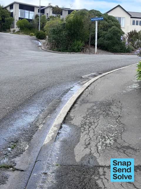
This leak has been going for well over a month so time I flagged it. It bubbles up through a crack between kerb and asphalt.
 Water Leak, 15 May 2024
Water coming out of the footpath and often the gutter drain is full to the top with water when there has been no rain
 Overgrown Vegetation, 20 Feb 2024
Cut back off road sight line issues
Elsewhere on Richmond Hill Road
- 61 Richmond Hill Road, 12 reports
- 127 Richmond Hill Road, 8 reports
- 177 Richmond Hill Road, 7 reports
- 89 Richmond Hill Road, 6 reports
- 66 Richmond Hill Road, 6 reports
- 3 Richmond Hill Road, 6 reports
- 70 Richmond Hill Road, 5 reports
- 54 Richmond Hill Road, 5 reports
The street’s crash record
NZTA’s record names Richmond Hill Road in 1 crash that hurt somebody since 2006, 0 seriously hurt, nobody killed.
The civic layer
This ground votes in Heathcote ward, the Spreydon-Cashmere-Heathcote community board is its local layer. Ward lines don’t always follow suburb lines; this one is measured at the pin, not the suburb’s centre. The whole roll is at /wards.
Richmond Hill Road, the whole record → · Everything about Richmond Hill → · What stood on this ground → · On the map → · From the air, RetroLens holds the Crown’s aerials back to 1936; search the address there →
Questions, answered briefly
6 council reports on record since February 2024, most often water leak (1), trees - general (1), street gutters / storm water (1).
Richmond Hill, Christchurch, on Richmond Hill Road.
Nothing on the heritage register at this exact spot, the record around this ground →
Greenwood Park, 71 m to its edge, 279 ha.