50 London Street, Richmond
17 reports on record since June 2022 · 15 with photographs. The street’s heaviest record is 78 London Street — 35 reports on file. Indicative rating valuation and school zones, hazards, bin day and what stood here before.
What gets reported here
Photographed here 15 on record


Reported here
 Street Cleaning —
Road in a bad state of repair, lots of loose shingle , needs a really good sweep.
 Pothole —
Outside 50 & 52 London Street Richmond, another lot !!
 General Request —
Is there any chance that you could paint some yellow no parking strips on both sides of the road on this bend , when traffic parks on both s
 Graffiti on a fence, building or structure —
 Graffiti on a fence, building or structure —
 Graffiti on a fence, building or structure —
 Road Signage —
Hi , could we PLEASE PLEASE have some 30 k signs put up on London Street Richmond. This is a street that needs some urgent attention to help
 Fallen Tree —
Cabbage tree outside 52 London Street Richmond, a lot of dead branches falling off , HAZARD ON TGE FOOTPATH
 Trees - General —
This old cabbage tree needs a big trim as old dead branches are breaking off and falling into the foot path , very dangerous, especially wit
 Pavement - General —
The gutter is full of flax leaves , has not been cleaned for a long time
- Pothole —
- Trees - General —
 Graffiti —
 Vandalism - General —
On wall 56 London street Richmond
 Vandalism - General —
Outside 50a London street Richmond
 Vandalism - General —
52 London street Richmond
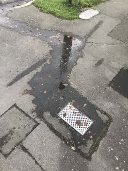 Water Leak —
Outside 50London St Richmond
Also reported on London Street
- 78 London Street — 35 reports
- 26 London Street — 25 reports
- 68 London Street — 24 reports
- 74 London Street — 17 reports
- 35 London Street — 15 reports
- 33 London Street — 14 reports
- 52 London Street — 12 reports
- 44 London Street — 12 reports
The street’s crash record
NZTA’s record names London Street in 14 crashes that hurt somebody since 2006 — 1 seriously hurt, nobody killed.
The green nearby
- Richmond Playground — 117 m to the edge
- Alexandra Park — 215 m to the edge
- Barbadoes Cemetery — 435 m to the edge · Botanic · 3 ha
- Avon Riverbank Central City — 451 m to the edge · 6 ha
- Avebury Park — 484 m to the edge · Botanic
Parks within half a kilometre, measured to the boundary — the council’s open data.
On the doorstep
- Richmond Neighbourhood Cottage — 139 m away · Venues & events
- Richmond Workingmen's Club — 170 m away · Clubs
- The Borough, Sections Cafe And The Junction Function Centre — 170 m away · Venues & events
- Sun Ning Takeaways — 190 m away · Fast food
Businesses within four hundred metres, measured at the pin — OpenStreetMap and the council directories.
The bus nearby
- Stanmore Rd near London St — 204 m away · route 60, the Orbiter (anticlockwise)
- Stanmore Rd near Warwick St — 215 m away · route 60, the Orbiter (clockwise)
The closest Metro stops, within four hundred and fifty metres.
The tracks through here
- Walk and bike track through Richmond — 198 m to the line · walk · bike
- Walk and bike track through Richmond — 275 m to the line · walk · bike
- Walk and bike track through Richmond — 332 m to the line · walk · bike
- Walk and bike track through Richmond — 395 m to the line · walk · bike
- Walk and bike track through Richmond — 415 m to the line · walk · bike
Tracks whose line passes within half a kilometre, measured to the line itself — the council’s open data.
The named ground
Named water within 500 m of this address, measured to the line or the edge — the open map’s record.
The remembered names nearby
- In Commemoration of the Centenary of Women’S Suffrage — 184 m away ·
In Commemoration of the Centenary of Women’s Suffrage Hagley Ferrymead Community Board Nov
· 2009
Inscribed plaques within two hundred and fifty metres — the register’s pins, not surveyed spots. The whole roll is at /plaques.
Renting nearby
new bonds in Richmond ran about $499 a week — $51 below the city median of $550 — the suburb page keeps the rent record →.
The civic layer
This ground votes in Central ward — the Papanui-Innes-Central community board. Ward lines don’t always follow suburb lines; this one is measured at the pin, not the suburb’s centre.
What stood on this ground → · On the map → · From the air — the Crown’s aerials back to 1936; search the address on RetroLens →
Questions, answered briefly
17 council reports on record since June 2022 — most often vandalism - general (3), graffiti on a fence, building or structure (3), trees - general (2).
Richmond, Christchurch — on London Street.
Nothing on the heritage register at this exact spot — the record around this ground →
Richmond Playground — 117 m to its edge.