67 Briggs Road, Shirley
14 reports on record since August 2021 · 9 with photographs. The most-reported address on Briggs Road. Indicative rating valuation and school zones, hazards, bin day and what stood here before.
What gets reported here
Photographed here 9 on record


Reported here
 Graffiti somewhere else —
  Graffiti somewhere else —
 Bollards
 Graffiti on a fence, building or structure —
  Accessibility —
 No cut downs or defined crossing location. It’s a busy crossing
 Accessibility —
 There are no cut down facilities for pedestrians to cross Briggs road on the west side of akaroa street
- Fallen Tree —
- Graffiti —
- Water Leak —
Water main been leaking for some time.. just north of the corner of Briggs and Akaroa st shirley
- Water Leak —
On the intersection of Briggs road in the road there is a water main leaking out on the road. Really need to be looked at soon before it get
 Water Leak —
 Water valve leaking
 Water Leak —
 Burst water main. Been like this for about 1 week
 Water Leak —
 Leaking sluice valve flowing a fair amount
- Water Leak —
Water is leaking out of the middle of the road, it is making the whole corner wet. In a frost this will be lethal for cars as they come off
 Roading/Streets —
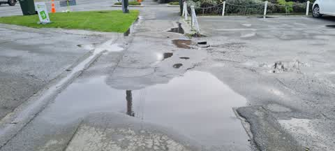
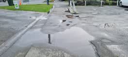
 Footpath needs repair. Please note the area floods in rain events which needs to addressed too.
Also reported on Briggs Road
- 73C Briggs Road — 12 reports
- 77C Briggs Road — 11 reports
- 73B Briggs Road — 11 reports
- 77 Briggs Road — 10 reports
- 73A Briggs Road — 8 reports
- 73 Briggs Road — 8 reports
- 77A Briggs Road — 7 reports
- 75 Briggs Road — 7 reports
The street’s crash record
NZTA’s record names Briggs Road in 36 crashes that hurt somebody since 2006 — 10 seriously hurt, nobody killed.
The green nearby
- Macfarlane Park — 160 m to the edge · Sports ground · 8 ha
- Havana Gardens Reserve — 202 m to the edge · 1 ha
- Sanctuary Gardens Reserve — 386 m to the edge · 1 ha
Parks within half a kilometre, measured to the boundary — the council’s open data.
On the doorstep
- Sushi Ball House — 47 m away · Restaurants
- Wicked Fish & Chip Shop — 73 m away · Fast food
- Briggston Fish Supply — 86 m away · Fast food
- Briggston Chinese Takeaway & Fish'n Chips — 98 m away · Fast food
Businesses within four hundred metres, measured at the pin — OpenStreetMap and the council directories.
The bus nearby
The closest Metro stops, within four hundred and fifty metres.
The tracks through here
- Walk and bike track through Shirley — 208 m to the line · walk · bike
- Walk and bike track through Shirley — 275 m to the line · walk · bike
- Walk and bike track through Shirley — 297 m to the line · walk · bike
- Walk and bike track through Shirley — 376 m to the line · walk · bike
- Walk and bike track through Shirley — 465 m to the line · walk · bike
Tracks whose line passes within half a kilometre, measured to the line itself — the council’s open data.
The named ground
Named water within 500 m of this address, measured to the line or the edge — the open map’s record.
Renting nearby
new bonds in Shirley ran about $575 a week — $25 above the city median of $550 — the suburb page keeps the rent record →.
The civic layer
This ground votes in Innes ward — the Papanui-Innes-Central community board. Ward lines don’t always follow suburb lines; this one is measured at the pin, not the suburb’s centre.
What stood on this ground → · On the map → · From the air — the Crown’s aerials back to 1936; search the address on RetroLens →
Questions, answered briefly
14 council reports on record since August 2021 — most often water leak (6), graffiti somewhere else (2), accessibility (2).
Shirley, Christchurch — on Briggs Road.
Nothing on the heritage register at this exact spot — the record around this ground →
Macfarlane Park — 160 m to its edge, 8 ha.