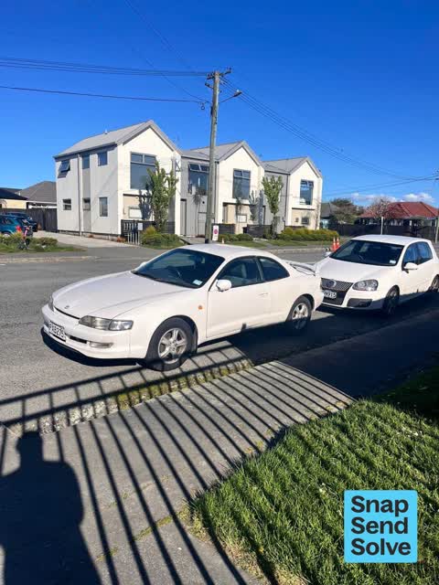
Hazard, vehicle35 Sabina St
Car is encroaching on my driveway. Have reported this vehicle multiple times for expired rego. Now making it difficult to access my driveway with current…
4,688 council reports since June 2015, the 31st busiest suburb in the city. 3,646 photographs on record. 7,140 people at the 2023 Census, 2,593 to the square kilometre across 2.8 km².
The record also holds about $575 a week to rent· 2023 Census snapshot· 3,646 photographs· 35 old photographs· 2 schools· 10 parks· 2 civic facilities· 3 places of worship· 9 tracks· 1 name on the map· 45.5% of the outline mapped liquefied· the record drew water over 2% of the outline· ecological sites over 1% of the outline· setback strips over 2% of the outline· 35% of the outline inside the plan’s density overlays· 1,794 SCIRT photographs filed on this ground· 12.9 km of cycleway crosses the outline· 7 drawn rules bind this ground· 2 parcels on the dangerous-work register· 184 parcels of made ground· the 2019 model grades this ground mostly medium· 2 council structures on the register· 3 recreation register records· 1,047 trees on the register· the plan’s word on this ground· 4% of the outline reserved· the plan’s exceptions touch 15% of the outline· 2 epicentres inside the outline· 248 injury crashes· 5,231 recorded victimisations· 38 bus stops· 178 businesses· the council’s fix times· 40 documents· 5 mentions on the wire
Link-outs to the source’s own live pages, chch.live does not copy their live values or source text.
New bonds here ran at about $575 a week in the April–June 2026 quarter, the middle half of them between $537 and $618, across 24 bonds lodged, up 5% on a year ago. That’s about $25 a week above the city’s own quarter median of $550. Tenancy Services counts these under the Shirley West and Shirley East areas combined, approximately this suburb.
Median and quartiles of weekly rents on new private bonds, by quarter; suburb figures are a bond-weighted blend of the areas. New bonds are fresh lodgements, not the whole rental stock; under five bonds the rent is withheld, and counts are randomly rounded. Source: Tenancy Services rental bond data: provisional while the bond system migrates.
The ground: the February 2011 survey drew liquefaction over 46% of it; the flood record drew water over 2% of it, the rest of the watch is drawn further down.
Day to day it holds 2 schools, 10 parks, 2 civic facilities, 3 places of worship, 9 tracks and 38 bus stops, each is counted further down.
Lately the record’s mostly graffiti & vandalism, 660 reports in the year to 12 October 2026, the newest 11 October 2026.
One for the quiz, Its busiest day on record was 4 January 2022, 36 reports in a single day.
About 6,876 people and 2,565 occupied private households in the “Shirley East” and “Shirley West” areas, grouped from 46 SA1 areas. Several statistical areas are combined here, so this is a grouped proxy rather than a count for one suburb boundary.
Ethnicity is a multiple-response measure, so those percentages are not meant to add to 100%.
Stats NZ’s 2023 Census uses fixed random rounding to base 3. Unavailable or confidential cells are left out, not treated as zero. individuals · households · geography · CC BY 4.0.
Shirley, sometimes referred to as Windsor, is a suburb of Christchurch, New Zealand, about 5 kilometres (3.1 mi) north-east of the city centre. The area was used for farming from the 1850s, and subdivision started in the early 20th century, with most of the houses being built between 1950 and 1980.
Placed by the record’s locality join or the name in its own title, a lead, not a claim each frame stood here.
Car is encroaching on my driveway. Have reported this vehicle multiple times for expired rego. Now making it difficult to access my driveway with current…

omg how filthy are some people ?? This creek is continuously been used as a dump
Contractors vehicles blocking view of road when coming out of Palm Drive onto Briggs Rd. I have to pull out too far to see if any traffic is coming down the…


over growth needs cut back down all way. I understand the over growth is on private property but I believe the council can still send a letter to the property…

Log in stream causing water rise downstream. Noticed higher water levels for about a week.

When bus hits this repair line in the road travelling east to west it causes houses to shake on lake tce rd.
From approx 0:00hrs until approx 04:00hrs regularly during week mornings there is significant construction works noise, affecting sleep. Other neighbours are…


horseshoe Lake reserve toilets . the ccc laminated sign saying out of order is attracting written responses, so it's not just me caught short. fixing would be…
The median council work order pinned in Shirley took 3 days to resolve, the city-wide median is 3 days, so this ground runs faster than the city as a whole. The slowest tenth waited 3 months or longer. 130 tickets are open here now, the oldest was filed 26 October 2018.
Work orders, not the resident reports above, the council’s MyCouncilTicket stream, and one job can appear in both. A median counts only finished jobs; open ones are named as open, never averaged in. The ticket roll · the whole city’s fix times.
One sensitive site stands here, Te Oraka Shirley Intermediate School, and the Local Alcohol Policy restricts new off-licences within 200 m of it.
The council’s bylaw zones and the Local Alcohol Policy’s buffer list, read from the Regulatory open-data service. A ban rules drinking in public places; it says nothing about whether a premises may sell, that is the licence register’s job.
Zoned for Christchurch Adventist School · Emmanuel Christian School · Mairehau High School · Marian College · Middleton Grange School · St Bede's College · and 8 more zones, the drawn zone is indicative; the Ministry’s written scheme is the legal boundary.
Decile and EQI describe the community a school draws from, not how well it teaches.
The first eight of 10, Parks and reserves in the council’s open data, a park lands in the suburb its centre falls inside. The whole roll is at /parks.
Libraries, halls, cemeteries and the rest in the council’s open data, a facility lands in the suburb its point or centre falls inside. The whole shelf is at /facilities.
Places of worship in the open map’s record, one lands in the suburb its building stands in. The whole roll is at /worship.
The first eight of 9, Tracks in the council’s open data, a line belongs to every suburb it passes through. The whole network is at /tracks.
The February 2011 survey drew mapped ground failure over 45.5% of this outline, about 125 hectares. A patch is a footprint, not a finding about an address; the count for the whole city is at /liquefaction.
The flood record drew water over 2.0% of this outline, about 6 hectares, across 1 named event. A patch is one event’s observation, not a live hazard finding; the whole record is drawn at /floods.
2 parcels inside this outline sit on the hazardous-activities register, mostly chemical manufacture, application and bulk storage, vehicle refuelling, service and repair, 2 still doing the work. A listing records the work, not a soil test; the whole register is drawn at /hazards.
The files record 184 parcels of made or characterised ground inside this outline, about 47 hectares, mostly sand, engineered fill, topsoil, 1 carry fill the file can’t vouch for. A record is the file’s word on what was laid, not a fresh survey; the whole layer is drawn at /fill.
The 2019 liquefaction study put 82% of this outline in the medium class, and 3 assessed areas here carry the free-face flag for possible lateral spreading. A class is the model’s verdict on a patch of ground, not a finding about an address; the whole study is drawn at /vulnerability.
The council’s structure register stands 2 assets on this ground, 1 viewing platform, 1 jetty, sited at Sanctuary Gardens Reserve. The register’s site names are its own labels for the ground an asset stands in; the layer is drawn at the map.
The recreation register keeps 3 records inside this outline, bookable surfaces for 2 basketball, 1 cricket. Seasons and surfaces are the register’s record, not this week’s draw; the layer is drawn at the map.
The register counts 1,047 living trees inside this outline, 3 veterans among them, 28 carrying a protection, mostly Scarlet Oak, Ribbonwood, Golden Elm. The file remembers 692 trees felled here. A tree record is the register’s word on what stands or stood; the whole canopy is drawn at /trees.
The plan files 19% of this outline under Open Space Metropolitan Facilities, 51% residential, the rest mostly High density residential zone 18%, Medium density residential zone 17%. A zone is a permission, not a description, the mix is read from a sampled join of the plan’s polygons; the whole district is drawn at /zones.
The plan reserves about 10 hectares of this outline, 4%, under 3 designations, mostly learning. A designation is a claim on the ground, not a build date, the mix is read from a sampled join; the whole register is drawn at /designations.
The plan’s exceptions touch 15% of this outline, 1 qualifying matter, mostly infrastructure. A matter narrows how the density rule applies, it does not forbid; the mix is read from a sampled join, and the cultural-significance areas are the plan’s own unnamed ones. The whole register is drawn at /matters.
The plan’s ecological schedules cover 1% of this outline across 1 scheduled site, all protected under Schedule A. Shares read from a sampled join; a recognition overlay, not a survey. The whole ledger is drawn at /ecology.
No high-hazard flood area covers this outline. The broader flood-management watch covers 27% of it, Dudley Creek, Avon River. Shares read from a sampled join; a model’s map, not a promise. The waiting water is drawn at /flood-hazard.
The plan’s water-margin layers cross this outline, 29 classified reaches, the plan calling Shirley Stream and No 1 Drain by name, 2% of it inside the setback strips, the widest holding 10 m off the bank. The margin is the plan’s drawing, not a survey of the bank; the reaches, strips and held edges are mapped at /water-margin.
The plan’s allowed shape holds this outline, 35% of it inside the residential overlays, the densest standing Medium Density. The shape is the plan’s permission, not a survey of what stands; the allowed shape is drawn at /density.
The rebuild’s cameras filed 1,794 photographs on this ground, 2010–2016, stormwater work mostly. Each frame is a receipt the dig left behind, a work log, not a survey of what stands now; the whole record is drawn at /rebuild.
The pedal network threads this ground, 12.9 km of cycleway crosses the outline. A segment counts under every suburb its path enters; the whole network is drawn at /cycleways.
The rulebook binds this ground, 7 drawn instruments, 2 of them dog rules, 5 bottle-store buffers; the outline sits inside the takiwā of Te Ngai Tuahuriri Runanga. The bylaw is the instrument, this the map of it, the whole rulebook is drawn at /rules.
GeoNet’s catalogue puts 2 magnitude-3+ epicentres inside this outline since the sequence opened, the biggest a M3.2 in 2011. An epicentre is where the instruments placed the break, not a measure of the shaking here; the whole catalogue is counted at /sequence, the live record is /quakes, and the story in plain language is the earthquakes explainer.
The named waterways, bays, headlands, monuments, summits and old sites OpenStreetMap puts inside this outline, a pin is the mapper’s own; a waterway belongs to every suburb it crosses. Every roll, counted: /geography.
248 crashes that hurt somebody on record inside Shirley's outline, 1 person killed, 50 seriously hurt.
The corner that keeps appearing: Shirley Road at Marshland Road, 15 injury crashes.
5,231 victimisations on the Police record inside Shirley’s outline, September 2022–August 2026, mostly theft, about 190 a year per 1,000 residents. Down 14% on the year before. Reported is not all, how much never reaches the record depends on the offence.
38 Metro stops inside Shirley's outline, in ECan’s stop record, served by route 44, route 60, route 135, route 7, route 100, route 110, the Orbiter (anticlockwise), the Orbiter (clockwise).
178 premises in Shirley across 57 kinds, from OpenStreetMap, the council’s licensed-premises register and its 2024 Find Christchurch directory. Each kind below opens at this suburb’s shelf.
Among them, the ones the record says most about:
What the archive’s sources say about Shirley, titled for it, turned up by a search for one of its places, or carrying its name in the text. These are leads and citations: the originals live at the provider, linked from each row.
…rd blackstone walsall sott s wareham drax s warriiigton blackburne warwick south mordaunt shirley warwick douglas collins warwickshire north dugdale uilmot wells blakemore haytcr s wenlock forrester g…New Zealand Gazette and Wellington Spectator · Papers Past · National Library of New Zealand · · text held
…eet christchurch mason t button benjamin cashel street christchurch painter buxton joseph shirley market place christchurch saddler il cain john nearjthe race-course farmer cameron donald saltwater cr…Lyttelton Times · Papers Past · National Library of New Zealand · · text held
…l section no 2320 buss william rangiora leasehold land part of section 2777 buxton joseph shirley chmtchurch freehold 200 acres land on mount grey downs beswiek william cockerill kaiapoi freehold 2 ac…Lyttelton Times · Papers Past · National Library of New Zealand · · text held
…issuing land broker licenses w s moorhouse 3303 registrar-general of land wesleyan church shirley the third anniversary tea meeting in connection with the above place of worship will be held there on…Star · Papers Past · National Library of New Zealand · · text held
…ght under the house out of sight the spade was found near the porch in the morning edward shirley i live on matheson road near complainants on the ferry road side cronin lives next door to me nearer t…Star · Papers Past · National Library of New Zealand · · text held
…go seotion 2159 linooln district samuel lindsay farm weedonsj joseph maraden sootion 1107 shirley m milburn sootion 20645 hciuhoote john rountreo farm sandhills j j p ooallaghan seotion 108 fendalltow…Star · Papers Past · National Library of New Zealand · · text held
…ednesday 16th february sale op a nice v freehold and bakery at featherston at 2 oclock at shirley hotel p eorge thomas will sell by auction on jt wednesday the half acre part of section 553 on which i…Evening Post · Papers Past · National Library of New Zealand · · text held
…n harewood road f peiper section 8103 heathcote the application of j e ingle section 1107 shirley was objected to sergeant colman stated that a great stenoh arose through defendant throwing out pig of…Star · Papers Past · National Library of New Zealand · · text held
…tone springaton messrs howard and dartnoll mr major southbridge mr h paddy mr james lewis shirley mr mumford stunner mrs terry sef ton messrs vaughan and cordner sheffield messrs j barr and co southbr…Timaru Herald · Papers Past · National Library of New Zealand · · text held
…ms 34 triangle colombo street christchurch t market gardener chas collins market gardener shirley and victoria street chrislohurch wholesale and export 1 orders to be ad dressed victoria street 633 ma…Star · Papers Past · National Library of New Zealand · · text held
The rest are a search away, the whole shelf, for the name →
Compare Shirley with Mairehau · Dallington · Edgeware · Richmond · Burwood · Avonside, same record, side by side.
Shirley, sometimes referred to as Windsor, is a suburb of Christchurch, New Zealand, about 5 kilometres (3.1 mi) north-east of the city centre. The public record holds 4,688 council reports for it, the first filed in June 2015.
7,140 people at the 2023 Census, 2,593 per square kilometre across 2.8 km².
About 6,876 people and 2,565 occupied private households (combined SA2s): grouped from Stats NZ SA1 areas through this site’s suburb join. Indicative, not a LIM.
4,688 reports on record, most often graffiti & vandalism (1,731), rubbish & dumping (755), water & drains (746). 660 of them in the year to 12 October 2026.
248 injury crashes on the police record inside the suburb’s outline, 1 person killed, 50 seriously hurt. The suburb’s crashes, mapped →
GeoNet’s catalogue puts 2 magnitude-3+ epicentres inside the suburb’s mapped outline since the September 2010 mainshock, the biggest a M3.2 in 2011. An epicentre is where the instruments placed the break, not a measure of the shaking felt here. The whole sequence, counted → · The story, in plain language →
Every suburb in Christchurch → · Its decade, charted → · the whole A–Z →
Work orders, not the resident reports above, the council’s MyCouncilTicket stream, and one job can appear in both. A median counts only finished jobs; open ones are named as open, never averaged in. The ticket roll · the whole city’s fix times.
The council’s bylaw zones and the Local Alcohol Policy’s buffer list, read from the Regulatory open-data service. A ban rules drinking in public places; it says nothing about whether a premises may sell, that is the licence register’s job.
Ministry of Education directory, the final decile and the current Equity Index describe the community a school draws from, not how well it teaches. Zones are indicative; the written enrolment scheme rules.
Parks and reserves in the council’s open data, the park lands in the suburb its centre falls inside; one that straddles the line keeps its own address.
Libraries, halls, cemeteries and the rest in the council’s open data, a facility lands in the suburb its point or centre falls inside.
Places of worship in the open map’s record, one lands in the suburb its building stands in. The whole roll is at /worship.
Marae in the region’s roll, a marae stands where it stands; the join names the suburb the roll files it under. The whole roll is at /maraes.
Walking, biking, horse and off-road tracks in the council’s open data, a line belongs to every suburb it passes through.
OpenStreetMap’s own record, inside this outline, a pin is the mapper’s; a waterway belongs to every suburb it crosses. Every roll, counted: /geography.
Heritage places the council’s district plan or Heritage New Zealand list inside this suburb, each with what is known about it and the document it is known from.
The register’s era records for places in this suburb, what stood on the ground, and when.
Each of these is a decade of reports, the heritage places on the register, what is known about them, and the documents behind it, everything the archive holds about the part of the city it names.