Billys Track
14 reports at 1 address in Mount Pleasant, the first in 2022, the latest 2026. 14 separate days somebody filed something about it.
Where it runs
Each report dot is the average of the spots reports were filed from, where reporters stood on Billys Track, not the street’s surveyed line. The strong outline is Mount Pleasant.
From the air, then
Sourced from Canterbury Maps and partners. RNZAF, CC BY 3.0 NZ. Each frame is cut from Environment Canterbury’s historic imagery MapServer for that decade, only where the Footprints layer names a CC BY survey (NZAM-covered spots stay out). RetroLens holds more Crown aerials →
The addresses on it
- 132 Billys Track, 14 reports
What got reported
- Roads & footpaths, 7 reports
- Water & drains, 5 reports
- Rubbish & dumping, 1 report
- Everything else, 1 report
Year by year
- 2022, 2 reports
- 2023, 2 reports
- 2024, 4 reports
- 2025, 4 reports
The crash record on it
NZTA’s record names Billys Track in 3 crashes that hurt somebody since 2006, 1 seriously hurt, nobody killed.
Its file in the papers
Papers Past records that surfaced when the archive searched for the street’s name, they answered the search; whether they are about this street is a reader’s call, at the link.
- A FLYING TRIP THROUGH NEW ZEALAND (Otago Daily Times, 28 May 1886) · Otago Daily Times,
- A FLYING TRIP THROUGH NEW ZEALAND. (Otago Witness, 28 May 1886) · Otago Witness,
- SPORTING. (Otago Daily Times, 04 January 1889) · Otago Daily Times,
- A WALK TO AKAROA. (Star, 12 May 1894) · Star,
- MANAPOURI AND TE ANAU TO MILFORD SOUND. (Otago Daily Times, 30 January 1897) · Otago Daily Times,
- MANAPOURI AND TE ANAU TO MILFORD SOUND. (Otago Witness, 11 February 1897) · Otago Witness,
- FROM LAKE MANAPOURI TO DOUBTFUL SOUND. (Otago Witness, 24 February 1904) · Otago Witness,
- SPORTING (Taranaki Daily News 21-4-1919) · Taranaki Daily News,
- METROPOLITAN TROTS. (Hawera & Normanby Star, 11 August 1919) · Hawera & Normanby Star,
- METROPOLITAN T.C. MEETING (Wanganui Chronicle, 11 August 1919) · Wanganui Chronicle,
- SPORTING (Evening Post, 12 August 1919) · Evening Post,
- SPORTING (Taranaki Daily News 11-8-1919) · Taranaki Daily News,
- SPORTING (Taranaki Daily News 12-11-1919) · Taranaki Daily News,
- RACING NEWS (Grey River Argus, 01 May 1920) · Grey River Argus,
- SPORTING (Grey River Argus, 10 August 1920) · Grey River Argus,
- SPORTING. (Taranaki Daily News 17-8-1920) · Taranaki Daily News,
- SPORTING. (Taranaki Daily News 10-8-1920) · Taranaki Daily News,
- CHRISTCHURCH TROTS-SECOND DAY. (Hawera & Normanby Star, 12 November 1920) · Hawera & Normanby Star,
- TROTTING (NZ Truth, 15 April 1922) · NZ Truth,
- LURE OF THE WILD (Evening Post, 07 January 1936) · Evening Post,
As it was reported
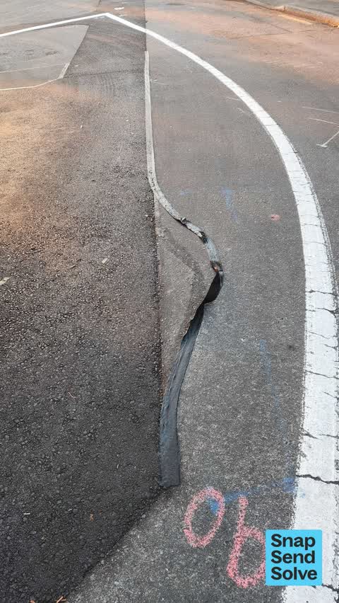


The latest on it
- Damaged Road, 132 Billys Track,
- Road Signage, 132 Billys Track,
- Street Gutters / Storm Water, 132 Billys Track,
- Damaged Road, 132 Billys Track,
- Accessibility, 132 Billys Track,
- Damaged Road, 132 Billys Track,
- Water Leak, 132 Billys Track,
- Dumped Rubbish, 132 Billys Track,
- Street Gutters / Storm Water, 132 Billys Track,
- Roads - General, 132 Billys Track,
- Street Gutters / Storm Water, 132 Billys Track,
- Pavement - Damaged, 132 Billys Track,
- Street Gutters / Storm Water, 132 Billys Track,
- General Request, 132 Billys Track,
Questions, answered briefly
In Mount Pleasant, Christchurch, New Zealand.
14 reports at 1 address, most often roads & footpaths (7), water & drains (5), rubbish & dumping (1).
2022, the record covers 14 separate days somebody filed something about it, through 2026.
Every street the archive knows → · Mount Pleasant → · This street as a feed →