Clyde Road
98 reports at 34 addresses in Upper Riccarton, the first in 2017, the latest 2026. 84 separate days somebody filed something about it.
Where it runs
Each report dot is the average of the spots reports were filed from, where reporters stood on Clyde Road, not the street’s surveyed line. The strong outline is Upper Riccarton.
From the air, then
Sourced from Canterbury Maps and partners. LINZ, CC BY 3.0 NZ. Each frame is cut from Environment Canterbury’s historic imagery MapServer for that decade, only where the Footprints layer names a CC BY survey (NZAM-covered spots stay out). RetroLens holds more Crown aerials →
The addresses on it
- 25 Clyde Road, 12 reports
- 6 Clyde Road, 8 reports
- 1 Clyde Road, 8 reports
- 15 Clyde Road, 6 reports
- 2 Clyde Road, 5 reports
- 11 Clyde Road, 4 reports
- 9 Clyde Road, 3 reports
- 7 Clyde Road, 3 reports
- 5 Clyde Road, 3 reports
- 40 Clyde Road, 3 reports
- 36 Clyde Road, 3 reports
- 3 Clyde Road, 3 reports
- 27 Clyde Road, 3 reports
- 23 Clyde Road, 3 reports
- 20 Clyde Road, 3 reports
- 8A Clyde Road, 2 reports
- 8 Clyde Road, 2 reports
- 30 Clyde Road, 2 reports
- 21 Clyde Road, 2 reports
- 19 Clyde Road, 2 reports
- 18 Clyde Road, 2 reports
- 17-25 Clyde Road, 2 reports
- 16 Clyde Road, 2 reports
- 13A Clyde Road, 2 reports
- 42-40 Clyde Road, 1 report
- 4 Clyde Road, 1 report
- 38 Clyde Road, 1 report
- 32 Clyde Road, 1 report
- 28A Clyde Road, 1 report
- 28 Clyde Road, 1 report
- 19A Clyde Road, 1 report
- 15B Clyde Road, 1 report
- 13B Clyde Road, 1 report
- 10 Clyde Road, 1 report
What got reported
- Water & drains, 28 reports
- Graffiti & vandalism, 26 reports
- Roads & footpaths, 19 reports
- Rubbish & dumping, 9 reports
- Trees & parks, 7 reports
- Vehicles & parking, 5 reports
- Everything else, 4 reports
Year by year
- 2017, 1 report
- 2018, 1 report
- 2019, 3 reports
- 2020, 4 reports
- 2021, 8 reports
- 2022, 7 reports
- 2023, 21 reports
- 2024, 23 reports
- 2025, 23 reports
In the written record
Archive documents carrying the street’s name: leads and citations, not verified history. 60 on the shelf; the 10 earliest:
- Untitled (Otago Daily Times, 15 March 1870)
· Papers Past,
…flames a somewhat singalar accident says the cromwell argus happened last iifonday on the clyde road about four miles from cromwell by which a horse belonging to mr g smith carrier was nearly killed i…
- Te Whare Waiutuutu Kate Sheppard House - List No. 9325
· The New Zealand Heritage List/Rārangi Kōrero, 1888
Historic Place Category 1 List entry. Te Whare Waiutuutu Kate Sheppard House at 83 Clyde Road, Christchurch, built around 1888, was the home of pioneering New Zealand suffragist, Kate Sheppard,…
- CRICKET. (Star, 30 October 1896)
· Papers Past,
…nd w j jennings the match will commence at two oclock at the residence of mr w b clarkson clyde road on tuesday next a match was played at hagley park yesterday between the farmers co-operative associ…
- Page 1 Advertisements Column 5 (Otago Daily Times, 08 November 1899)
· Papers Past,
…ed for the pon toons of the mountaineer dredge where they are lying near feltons cromwell clyde road size of each pontoon 70ft long bft gin wide and 4ft 4iii deep tenders for the above will be receive…
- Page 2 Advertisements Column 4 (Daily Telegraph, 13 July 1901)
· Papers Past,
…honors through vie senior and intermediate grades of c examinations in pianoforte playing clyde road next high school mrs j w reid is prepared to teach singing in all its branches terms on application…
- Page 2 Advertisements Column 4 (Daily Telegraph, 15 July 1901)
· Papers Past,
…nors through the senior and intermediate grades of the examinations in pianoforte playing clyde road next high school mrs j w reid is prepared to teach singing in all its branches terms on application…
- Page 2 Advertisements Column 5 (Daily Telegraph, 16 July 1901)
· Papers Past,
…nors through the senior and intermediate grades of the examinations in pianoforte playing clyde road next high school mrs j w reid is prepared to teach singing in all its branches terms on application…
- Page 2 Advertisements Column 5 (Daily Telegraph, 17 July 1901)
· Papers Past,
…nors through the senior and intermediate grades of the examinations in pianoforte playing clyde road next high school mrs j w reid is prepared to teach singing in all its branches terms on application…
- Page 2 Advertisements Column 4 (Daily Telegraph, 19 July 1901)
· Papers Past,
…nors through the senior and intermediate grades of the examinations in pianoforte playing clyde road next high school mrs j w reid is prepared to teach singing in all its branches terms on application…
- Page 3 Advertisements Column 2 (Otago Daily Times 12-7-1902)
· Papers Past,
…Prize, Mrs M. Smith, 116 Adelaide y' w/f// /fS fill J 2nd Prize, Miss Nellie Sangster, 10 Clyde road, Wollington / f/ft f Avenue, Dunedin, £3 5s 11th Prize, M» M. Swart, Barewood, 2s 6d II })■ E ISf /…
The rest are a search away, the whole shelf, for the name →
The businesses on it, 2
Premises whose address in the directory is Clyde Road, the commercial record alongside the civic one.
The named ground
Named water within 150 m of a reported pin, measured to the line or the edge, the open map’s record.
The crash record on it
NZTA’s record names Clyde Road in 17 crashes that hurt somebody since 2006, 1 seriously hurt, nobody killed.
The corner the record returns to: Clyde Road & Riccarton Road, 58 crashes pinned to the pairing.
Its file in the papers
Papers Past records that surfaced when the archive searched for the street’s name, they answered the search; whether they are about this street is a reader’s call, at the link.
- Page 4 Advertisements Column 1 (Timaru Herald, 12 October 1874) · Timaru Herald,
- Page 19 Advertisements Column 1 (New Zealand Tablet, 30 April 1880) · New Zealand Tablet,
- Page 1 Advertisements Column 1 (Ellesmere Guardian, 09 September 1899) · Ellesmere Guardian,
- Page 1 Advertisements Column 4 (Akaroa Mail and Banks Peninsula Advertiser, 12 September 1899) · Akaroa Mail and Banks Peninsula Advertiser,
- Page 1 Advertisements Column 4 (Akaroa Mail and Banks Peninsula Advertiser, 15 September 1899) · Akaroa Mail and Banks Peninsula Advertiser,
- Page 1 Advertisements Column 4 (Akaroa Mail and Banks Peninsula Advertiser, 19 September 1899) · Akaroa Mail and Banks Peninsula Advertiser,
- Page 1 Advertisements Column 4 (Akaroa Mail and Banks Peninsula Advertiser, 22 September 1899) · Akaroa Mail and Banks Peninsula Advertiser,
- Page 1 Advertisements Column 4 (Akaroa Mail and Banks Peninsula Advertiser, 03 October 1899) · Akaroa Mail and Banks Peninsula Advertiser,
- Page 1 Advertisements Column 4 (Akaroa Mail and Banks Peninsula Advertiser, 17 October 1899) · Akaroa Mail and Banks Peninsula Advertiser,
- Page 1 Advertisements Column 4 (Akaroa Mail and Banks Peninsula Advertiser, 21 October 1899) · Akaroa Mail and Banks Peninsula Advertiser,
- Page 1 Advertisements Column 4 (Akaroa Mail and Banks Peninsula Advertiser, 24 October 1899) · Akaroa Mail and Banks Peninsula Advertiser,
- Page 1 Advertisements Column 4 (Akaroa Mail and Banks Peninsula Advertiser, 27 October 1899) · Akaroa Mail and Banks Peninsula Advertiser,
- Page 1 Advertisements Column 4 (Akaroa Mail and Banks Peninsula Advertiser, 31 October 1899) · Akaroa Mail and Banks Peninsula Advertiser,
- Page 1 Advertisements Column 4 (Akaroa Mail and Banks Peninsula Advertiser, 03 November 1899) · Akaroa Mail and Banks Peninsula Advertiser,
- Page 1 Advertisements Column 4 (Akaroa Mail and Banks Peninsula Advertiser, 10 November 1899) · Akaroa Mail and Banks Peninsula Advertiser,
- Page 1 Advertisements Column 4 (Akaroa Mail and Banks Peninsula Advertiser, 17 November 1899) · Akaroa Mail and Banks Peninsula Advertiser,
- Page 1 Advertisements Column 4 (Akaroa Mail and Banks Peninsula Advertiser, 24 November 1899) · Akaroa Mail and Banks Peninsula Advertiser,
- Page 1 Advertisements Column 4 (Akaroa Mail and Banks Peninsula Advertiser, 12 December 1899) · Akaroa Mail and Banks Peninsula Advertiser,
- Page 1 Advertisements Column 4 (Akaroa Mail and Banks Peninsula Advertiser, 20 December 1899) · Akaroa Mail and Banks Peninsula Advertiser,
- Page 1 Advertisements Column 4 (Akaroa Mail and Banks Peninsula Advertiser, 22 December 1899) · Akaroa Mail and Banks Peninsula Advertiser,
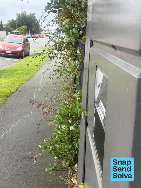
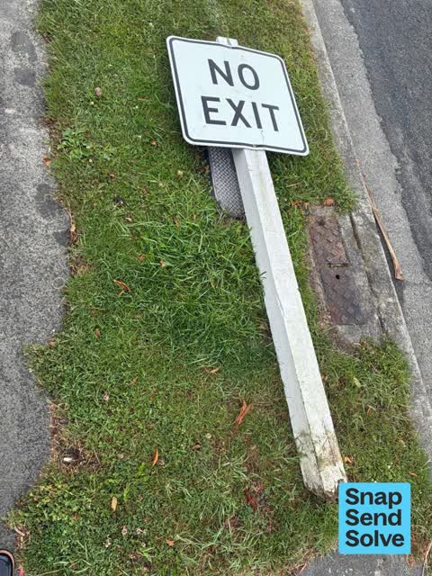
As it was reported




The latest on it
- Water Leak, 6 Clyde Road,
- Water Leak, 15 Clyde Rd,
- Graffiti on a fence, building or structure, 1 Clyde Rd,
- Overgrown Vegetation, 25 Clyde Rd,
- Overgrown Vegetation, 11 Clyde Rd,
- Overgrown Vegetation, 21 Clyde Rd,
- Damaged Road, 7 Clyde Rd,
- Water Leak, 15B Clyde Rd,
- Overgrown Vegetation, 25 Clyde Rd,
- Water Leak, 9 Clyde Rd,
- Water Leak, 7 Clyde Rd,
- Hazard, vehicle, 11 Clyde Rd,
- General Request, 15 Clyde Rd,
- Graffiti on a traffic light pole or cabinet, or wa, 1 Clyde Rd,
- Overgrown Vegetation, 25 Clyde Rd,
Questions, answered briefly
In Upper Riccarton, Christchurch, New Zealand.
98 reports at 34 addresses, most often water & drains (28), graffiti & vandalism (26), roads & footpaths (19).
2017, the record covers 84 separate days somebody filed something about it, through 2026.
Clyde Road and Riccarton Road, 58 police-reported crashes at the pairing.
Every street the archive knows → · Upper Riccarton → · This street as a feed →