43 Nayland Street, Sumner
11 reports on record since March 2022 · 7 with photographs. The street’s heaviest record is 26 Nayland Street — 23 reports on file. Indicative rating valuation and school zones, hazards, bin day and what stood here before.
What gets reported here
- Rubbish and Bins - General — 2
- Pavement - Damaged — 2
- Water Leak — 1
- Water General — 1
- Sewer General — 1
- Road Signage — 1
Photographed here 7 on record


Reported here
 Water Leak —
 Leaking water meter outside Sumner Laundromat
 Hazard — vehicle —
 No yellow lines on road so cars parked at bus stop and bus cannot pull in
 Graffiti on a road, footpath or bridge —
 On the pavement outside Sumner pharmacy
- Pavement - Damaged —
Hole in pavement by lampost
 Rubbish and Bins - General —
 This wine barrel has been dumped here for some time needs removing
- Pavement - Damaged —
- Rubbish and Bins - General —
- Road Signage —
 Sewer General —
 This is in front of Bohemian Bakery on the footpath to the Supervalue supermarket. Drain cover is damaged and will not seat safely. Some has
 Water General —
 Supply valve cover is broken in the car park by bohemian bakery in Sumner. Trip hazard.
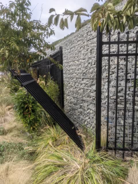
 Parks —
 Broken fence
Also reported on Nayland Street
- 26 Nayland Street — 23 reports
- 24 Nayland Street — 11 reports
- 2B Nayland Street — 9 reports
- 67 Nayland Street — 8 reports
- 56 Nayland Street — 8 reports
- 27 Nayland Street — 7 reports
- 140 Nayland Street — 7 reports
- 87 Nayland Street — 6 reports
The street’s crash record
NZTA’s record names Nayland Street in 10 crashes that hurt somebody since 2006 — 1 person killed, 3 seriously hurt.
The green nearby
- Greenwood Park — 60 m to the edge · Regional · 279 ha
- Sumner Croquet Reserve — 157 m to the edge
- Scarborough Beach — 188 m to the edge · Regional · 5 ha
- Sumner Beach — 282 m to the edge · Regional · 8 ha
- Cave Rock Reserve — 327 m to the edge · Regional
Parks within half a kilometre, measured to the boundary — the council’s open data.
The civic shelf nearby
- Matuku Takotako/sumner Library — 56 m away · Library · Nayland Street, Sumner
Libraries, halls and the rest within half a kilometre — the council’s open data.
On the doorstep
- 4Shore Sumner — 7 m away · Bars & pubs
- Almeidas Tapas Bar — 8 m away · Restaurants
- The Village Grape Bar — 8 m away · Bars & pubs
- 4 Shore Sumner — 10 m away · Bars & pubs
Businesses within four hundred metres, measured at the pin — OpenStreetMap and the council directories.
The bus nearby
- Wakefield Ave near Nayland St — 58 m away · route 3
- Marriner St near Wakefield Ave — 111 m away · route 3
The closest Metro stops, within four hundred and fifty metres.
The tracks through here
- Walk and bike track through Sumner — 224 m to the line · walk · bike
- Walk and bike track through Sumner — 393 m to the line · walk · bike
Tracks whose line passes within half a kilometre, measured to the line itself — the council’s open data.
The named ground
Named places within 1.5 km of this address; the council’s own structure register — bridges, boardwalks and steps standing nearby — the open map’s record.
The remembered names nearby
- In Memory of Mary Jackson — 194 m away ·
IN MEMORY OF MARY JACKSON
· 2000 - Scarborough Beach Developed plaque — 194 m away ·
(illegible – bench plaque too distant)
· 2013 - Harold Sinclair 1989 — 217 m away ·
HAROLD SINCLAIR 1989
· 2000
Inscribed plaques within two hundred and fifty metres — the register’s pins, not surveyed spots. The whole roll is at /plaques.
Renting nearby
new bonds in Sumner ran about $620 a week — $70 above the city median of $550 — the suburb page keeps the rent record →.
What was here — Dwelling and Setting
231 m away · 62 Nayland Street · located to ±13 m · the place’s own record →
On the register. Nothing researched here yet.
The civic layer
This ground votes in Heathcote ward — the Spreydon-Cashmere-Heathcote community board. Ward lines don’t always follow suburb lines; this one is measured at the pin, not the suburb’s centre.
What stood on this ground → · On the map → · From the air — the Crown’s aerials back to 1936; search the address on RetroLens →
Questions, answered briefly
11 council reports on record since March 2022 — most often rubbish and bins - general (2), pavement - damaged (2), water leak (1).
Sumner, Christchurch — on Nayland Street.
The heritage register names a place at or beside it — Dwelling and Setting.
Greenwood Park — 60 m to its edge, 279 ha.