279 Colombo Street, Sydenham
23 reports on record since May 2022 · 20 with photographs. The street’s heaviest record is 468 Colombo Street — 71 reports on file. Indicative rating valuation and school zones, hazards, bin day and what stood here before.
What gets reported here
Photographed here 20 on record


Reported here
- Dumped Rubbish —
corrugated iron sheet
 Road Signage —
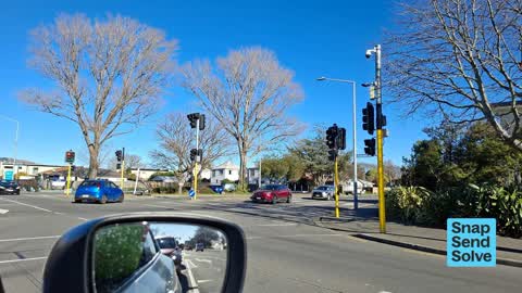
 There is no visible Mikton St street sign at this corner. As I drove further south on Colombo i found a sign about 15m further on ... which
 Hazard — vehicle —
 282 Colombo st sign facing wrong way.
 Damaged Road —
 Road has sunk, ( end of previous patch up) Colombo Street Sydenham mid road, out from Mobil Station. Near corner Huxley Street. Thanks.
 Graffiti on a fence, building or structure —
  Graffiti on a sign, mural or public art —
  Graffiti on a cabinet, pole or railway asset —
 EKOE black paint tags on traffic controller by 279 Colombo Street.
 Graffiti on a sign, mural or public art —
 EKOE gray paint tag on Sushi Cafe sign by 279 Colombo Street. If not in scope please ask Sushi Cafe to clean it up.
 Graffiti on a fence, building or structure —
 Graffiti on ccc box
 Graffiti somewhere else —
  Graffiti somewhere else —
  Graffiti somewhere else —
  Graffiti somewhere else —
  Graffiti somewhere else —
 X3
 Graffiti on a cabinet, pole or railway asset —
 Black paint tag on electrical asset at 279 Colombo Street.
 Poles and Signage - General —
 This east-facing road Milton Street) at the Colombo St corner hadc traffic kudos l lights alerted after the EQ. I know this becoz it was my
 Graffiti somewhere else —
  Road Signage —
 red right hand turning arrow shade is bent. ( turning into Colombo st )
- Graffiti —
- Graffiti —
 Dumped Rubbish —
  Graffiti —
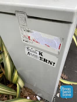
 Anti democratic sticky tags need complete removal from this GEC asset adjacent to the Eclipse traffic controller by 289 Colombo Street.
 Rubbish/Recycling —
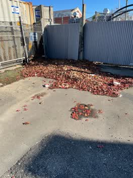
 The drains on thus Street are all blocked up with leaves and large piles of leaves at street end. In addition drain cover by Pizza Hut is mi
Also reported on Colombo Street
- 468 Colombo Street — 71 reports
- 300 Colombo Street — 66 reports
- 303 Colombo Street — 64 reports
- 504 Colombo Street — 56 reports
- 340 Colombo Street — 52 reports
- 406 Colombo Street — 37 reports
- 500 Colombo Street — 36 reports
- 420 Colombo Street — 36 reports
The street’s crash record
NZTA’s record names Colombo Street in 200 crashes that hurt somebody since 2006 — 2 people killed, 35 seriously hurt.
The green nearby
- Sydenham Park — 112 m to the edge · Sports ground · 5 ha
- Cadogan Reserve — 278 m to the edge
- Bradford Park — 281 m to the edge · Sports ground · 3 ha
- Jacksons Creek — 296 m to the edge
Parks within half a kilometre, measured to the boundary — the council’s open data.
On the doorstep
- Rayz Cutz — 42 m away · Hairdressers
- S. N. Market — 45 m away · Supermarkets
- Pizza Hut — 47 m away · Restaurants
- St Pierre's Sushi — 47 m away · Restaurants
Businesses within four hundred metres, measured at the pin — OpenStreetMap and the council directories.
The bus nearby
- Colombo St near Walton St — 104 m away · route 1, route 44
- Milton St near Drummond St — 108 m away · route 44
The closest Metro stops, within four hundred and fifty metres.
The tracks through here
- Walk and bike track through Sydenham — 11 m to the line · walk · bike
- Walk and bike track through Sydenham — 24 m to the line · walk · bike
- Walk and bike track through Sydenham — 144 m to the line · walk · bike
- Walk and bike track through Sydenham — 495 m to the line · walk · bike
Tracks whose line passes within half a kilometre, measured to the line itself — the council’s open data.
The named ground
Named water within 500 m of this address, measured to the line or the edge; the council’s own structure register — bridges, boardwalks and steps standing nearby — the open map’s record.
The remembered names nearby
- Sydenham Park plaque — 137 m away
Inscribed plaques within two hundred and fifty metres — the register’s pins, not surveyed spots. The whole roll is at /plaques.
Renting nearby
new bonds in Sydenham ran about $518 a week — $32 below the city median of $550 — the suburb page keeps the rent record →.
What was here — Former MED Substation and Setting
97 m away · 259 Milton Street · located to ±15 m · the place’s own record →
On the register. Nothing researched here yet.
What was here — Dwelling and Setting
137 m away · 12 Drummond Street · located to ±7 m · the place’s own record →
On the register. Nothing researched here yet.
The civic layer
This ground votes in Heathcote ward — the Spreydon-Cashmere-Heathcote community board. Ward lines don’t always follow suburb lines; this one is measured at the pin, not the suburb’s centre.
What stood on this ground → · On the map → · From the air — the Crown’s aerials back to 1936; search the address on RetroLens →
Questions, answered briefly
23 council reports on record since May 2022 — most often graffiti somewhere else (6), graffiti (3), road signage (2).
Sydenham, Christchurch — on Colombo Street.
The heritage register names 2 places at or beside it — Former MED Substation and Setting, Dwelling and Setting.
Sydenham Park — 112 m to its edge, 5 ha.