280 Cashmere Road, Westmorland
25 reports on record since April 2018 · 20 with photographs. The street’s heaviest record is 245 Cashmere Road — 50 reports on file. Indicative rating valuation and school zones, hazards, bin day and what stood here before.
What gets reported here
- Flooding — 5
- Dumped Rubbish — 4
- Overgrown Vegetation — 3
- Roading/Streets — 2
- Fallen Tree — 2
- Accessibility — 2
Photographed here 20 on record


Reported here
 Road Signage —
 scooter and signage thrown over bridge on Cashmere Road just after intersection with Hendersons Road. one sign in stream.
 Dumped Rubbish —
 Someone dumped this 2 nights ago in front of the house
- Dumped Rubbish —
 Flooding —
 Flooding from road works completed by CCC which unearthed a spring- the trench has soo much sediment and over grown grass it no longer drain
 Pothole —
 Broken road surface
 Overgrown Vegetation —
 Ccc area this is a fire risk and has been for 9 weeks we have reported to fire and emergency
 Overgrown Vegetation —
 Plant material left by Higgins contracted doing ccc reading work making it extremely dangerous for those walking between Westmorland and the
 Flooding —
 Roading has caused the problem but apparently it’s a 3 waters fix now 5 weeks of flooding on our property with no follow up. We are disguste
 Dumped Rubbish —
 This has been left behind by ccc contractor after they killed plants and left them to die, add wind and now blowing onto road this is the fo
 Flooding —
 Fat fingers didn’t mean to close previous job I was looking for an update. 2 days ago a lovely man from the council visited us and agreed it
- Accessibility —
The redeveloped road/bend underway needs to also provide mobility access and pedestrian access to the wetlands beyond the road expansion. Th
 General Request —
 Concerns for the safety of our community 1. Lack of safe walking cycling space between Westmorland and the wetlands. 2. The height of the r
 Accessibility —
 New built up path/road over 1.5m and. It retained! Huge risk of children falling also trees cut and left sticking out of grown! Work not com
 Overgrown Vegetation —
 Fire risk! Large amounts of vegetation has been uplifted and left to dry which is a huge fire risk! This needs to be removed
 Flooding —
 We found the spring that the ccc work has disrupted and is not poring water onto our property! We need this redirected please call 027707086
 Flooding —
 Spring causing flooding. Since the ccc has worked on the Henderson corner multiple springs have popped up causing flooding on our property.
 Poles and Signage - General —
 Safety mirror down
 Fallen Tree —
 Hi there. This fallen tree has been crashed into and up rooted. Can this please be passed onto the most appropriate team to get it removed .
 Fallen Tree —
 A few weeks ago, it looks like a vehicle has crashed into the tree on the corner of Cashmere and Hendersons Roads. There are pieces of damag
- Abandoned Vehicle —
- Street Gutters / Storm Water —
- Dumped Rubbish —
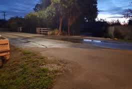 Water Leak —
 water has been across the road here for a few days, unclear where the leak is coming from
Roading/Streets —
road signs damaged or covered by trees. need reinstating for safety
Roading/Streets —
Slump on approach to bridge
Also reported on Cashmere Road
- 245 Cashmere Road — 50 reports
- 520 Cashmere Road — 13 reports
- 568 Cashmere Road — 10 reports
- 404 Cashmere Road — 9 reports
- 282 Cashmere Road — 6 reports
- 564 Cashmere Road — 5 reports
- 486 Cashmere Road — 5 reports
- 410 Cashmere Road — 5 reports
The street’s crash record
NZTA’s record names Cashmere Road in 15 crashes that hurt somebody since 2006 — 5 seriously hurt, nobody killed.
The green nearby
- Willowdell Reserve — 162 m to the edge
- Brookford Reserve — 213 m to the edge
- Francis Reserve — 375 m to the edge · 1 ha
- Highcrest Reserve — 437 m to the edge
Parks within half a kilometre, measured to the boundary — the council’s open data.
On the doorstep
- Christchurch Motorhome Site — 137 m away · Hostels
Businesses within four hundred metres, measured at the pin — OpenStreetMap and the council directories.
The bus nearby
- Penruddock Rse near Hamish Pl — 369 m away · route 44
- Penruddock Rse near Croftfield Pl — 394 m away · route 44
The closest Metro stops, within four hundred and fifty metres.
The tracks through here
- Walk and bike track through Westmorland — 43 m to the line · walk · bike
- Walk and bike track through Westmorland — 383 m to the line · walk · bike
Tracks whose line passes within half a kilometre, measured to the line itself — the council’s open data.
The named ground
Named water within 500 m of this address, measured to the line or the edge; the council’s own structure register — bridges, boardwalks and steps standing nearby — the open map’s record.
Renting nearby
new bonds in Westmorland ran about $700 a week — $150 above the city median of $550 — the suburb page keeps the rent record →.
The civic layer
This ground votes in Halswell ward — the Halswell-Hornby-Riccarton community board. Ward lines don’t always follow suburb lines; this one is measured at the pin, not the suburb’s centre.
What stood on this ground → · On the map → · From the air — the Crown’s aerials back to 1936; search the address on RetroLens →
Questions, answered briefly
25 council reports on record since April 2018 — most often flooding (5), dumped rubbish (4), overgrown vegetation (3).
Westmorland, Christchurch — on Cashmere Road.
Nothing on the heritage register at this exact spot — the record around this ground →
Willowdell Reserve — 162 m to its edge.